ബിഗ് ബെന്റ് ദേശീയോദ്യാനം
| Big Bend ബിഗ് ബെന്റ് | |
| National Park | |
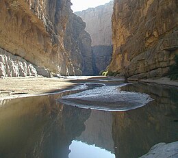
The Rio Grande, separating Mexico and the United States, within the walls of Santa Elena Canyon.
| |
| രാജ്യം | United States |
|---|---|
| സംസ്ഥാനം | Texas |
| Region | ചിഹ്വാഹുവാൻ മരുഭൂമി |
| പട്ടണം | ആല്പൈൻ |
| River | ഗ്രാന്റെ നദി |
| Location | ബ്ര്യൂസ്റ്റർ കൗണ്ടി, ടെക്സസ് |
| - coordinates | 29°15′0″N 103°15′0″W / 29.25000°N 103.25000°W |
| Highest point | |
| - location | എമോറി കൊടുമുടി, ചിസോസ് മലനിരകൾ |
| - ഉയരം | 7,832 അടി (2,387 മീ) |
| Lowest point | |
| - location | റിയോ ഗ്രാൻഡെ |
| - ഉയരം | 1,800 അടി (549 മീ) |
| Area | 801,163 ഏക്കർ (324,219 ഹെ) [1] |
| Founded | ജൂൺ 12, 1944 |
| Management | നാഷണൽ പാർക് സർവീസ് |
| Visitation | 388,290 (2016) [2] |
| IUCN category | II - National Park |
| Website: Big Bend National Park | |
അമേരിക്കയിലെ ടെക്സസിൽ മെക്സിക്കൊ അതിർത്തിയോട് ചേർന്ന് സ്ഥിതിചെയ്യുന്ന ഒരു ദേശീയോദ്യാനമാണ് ബിഗ് ബെന്റ് ദേശീയോദ്യാനം (ഇംഗ്ലീഷ്: Big Bend National Park). 1,200-ൽ അധികം ഇനം സസ്യങ്ങൾ, 450ലധികം ഇനം പക്ഷികൾ, 56 സ്പീഷീസ് ഉരഗങ്ങൾ, 75 സ്പീഷിസ് സസ്തനികൾ എന്നിവയെ ഇവിടെ കണ്ടുവരുന്നു.[3]
801,163 ഏക്കർ (324,219 ഹെ) ആണ് ഈ ദേശീയോദ്യാനത്തിന്റെ വിസ്തൃതി.[1] ക്രിറ്റേഷ്യസ്, സീനോസോയിക് കാലഘട്ടങ്ങളിലെ ഫോസിലുകൾ ഇവിടെനിന്നും കണ്ടെത്തിയിട്ടുണ്ട്.
ഭൂമിശാസ്ത്രം
[തിരുത്തുക]സസ്യജന്തുജാലം
[തിരുത്തുക]
ദേശീയോദ്യാനത്തിന്റെ ഭൂരിഭാഗവും മരുഭൂമിയാണെങ്കിലും, നിരവധി സസ്യവർഗ്ഗങ്ങൾ ഇവിടെ കാണപ്പെടുന്നുണ്ട്. ഇവിടെ കാണപ്പെടുന്ന 1,200 സസ്യ സ്പീഷീസുകളിൽ 60 എണ്ണം കള്ളിച്ചെടി ഇനങ്ങളാണ്, over 600 ലധികം ഇനം കശേരുകികളും, ഏകദേശം 3,600 ഷഡ്പദ ഇനങ്ങളും ഇവിടെ അധിവസിക്കുന്നു. വൈവിധ്യമാർന്ന ഭൂപ്രകൃതിയാണ് ഇവിടത്തെ ഈ ജൈവവൈവിധ്യത്തിനും കാരണം. ഉഷ്ണ മരുഭൂമികൾ, ഹിമം മൂടികിടക്കുന്ന പർവ്വതങ്ങൾ, ഫലഭൂയിഷ്ടമായ നദീതടങ്ങൾ എന്നിവ വിവിധ ജീവിവർഗ്ഗങ്ങൾക്ക് വാസസ്ഥാനമാകുന്നു.
മരുപ്രദേശത്ത് വസിക്കുന്ന മൃഗങ്ങളിൽ മിക്കവയേയും പകൽ സമയത്ത് കാണാൻ സാധിക്കാറില്ല. രാത്രികാലങ്ങളിലാണ് ഇവ ഭക്ഷണത്തിനും മറ്റുമായി പുറത്തിറങ്ങുന്നത്. പ്യൂമകളെയും (Puma concolor) ഈ ദേശീയോദ്യനത്തിൽ കണ്ടെത്തിയിട്ടുണ്ട്. എന്നിരിക്കിലും, കണക്കുകൾ പ്രകാരം ഇവിടെ വെറും രണ്ട് ഡസനോളം പ്യൂമകൾ മാത്രമേ വസിക്കുന്നുള്ളു.[4]
ചിത്രശാല
[തിരുത്തുക]-
Balanced Rock in Big Bend
-
Santa Elena Canyon
-
Pink lupine mingling with bluebonnets
-
Emory Peak's summit, the highest point in Big Bend National Park
-
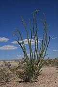
Ocotillo
-
Looking at the sunset behind the hills from Boquillas Canyon
-
Casa Grande (Spanish for "big house"), an iconic rock formation
-
Canyon walls viewed from The Window hiking trail
-
Lizard blending in with a rock formation
-
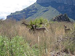
White-tailed deer near a hiking trail
-
Boquillas canyon trail during an incoming lightning storm.
അവലംബം
[തിരുത്തുക]- ↑ 1.0 1.1 "Listing of acreage as of December 31, 2011". Land Resource Division, National Park Service. Retrieved 2012-03-05.
- ↑ "Five Year Annual Recreation Visits Report". Public Use Statistic Office, National Park Service. Retrieved 2017-02-09.
- ↑ Gray, J.E.; Page, W.R., eds. (October 2008). Geological, geochemical, and geophysical studies by the U.S. Geological Survey in Big Bend National Park, Texas. Circular 1327. U.S. Geological Survey. ISBN 978-1-4113-2280-6.
- ↑ Uhler, John William. "Big Bend National Park Hiking Guide". Hillclimb Media. Archived from the original on 16 June 2008. Retrieved 2008-07-22.
പുറത്തേക്കുള്ള കണ്ണികൾ
[തിരുത്തുക]- Big Bend National Park website
- Big Bend National Park map (568 KB PDF file)
- Extensive travel information at American Southwest
- 10 Less-Traveled National Parks( Archived 2009-10-28 at the Wayback Machine. 2009-10-31)
- South and West Texas, a National Park Service Discover Our Shared Heritage Travel Itinerary
- Hike Journal of a trip into the Chisos Mountains includes pictures
- Castolon: A Meeting Place of Two Cultures,a National Park Service Teaching with Historic Places (TwHP) lesson plan Archived 2008-06-01 at the Wayback Machine.
- Big Bend collection guide, Walter Geology Library, The University of Texas at Austin
- Big Bend Overflight 1
- Big Bend Overflight 2
- "Big Bend National Park" 1940s promotional film for the park, possibly produced by the National Park Service
- BigBendChat Online forum for Big Bend discussion


