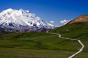
ഡെനാലി ദേശീയോദ്യാനം
| ഡെനാലി ദേശീയോദ്യാനം | |
|---|---|
ഐ.യു.സി.എൻ. ഗണം VI (Managed Resource Protected Area) | |
 ഡെനാലി പർവ്വതം | |
| Location | ഡെനാലി ബോറോ, മാറ്റനുസ്ക-സുസിറ്റ്ന ബോറോ, അലാസ്ക |
| Nearest city | ഹെലെയ് |
| Coordinates | 63°20′N 150°30′W / 63.333°N 150.500°W |
| Area | 4,740,911 acres (19,185.79 km2) (park) and 1,304,242 acres (5,278.08 km2) (preserve)[1] |
| Established | February 26, 1917 |
| Visitors | 587,412 (in 2016)[2] |
| Governing body | നാഷണൽ പാർക്ക് സർവീസ് |
| Website | ഡെനാലി നാഷണൽ പാർക് ആൻഡ് പ്രിസർവ് |
അമേരിക്കൻ ഐക്യനാടുകളിലെ മദ്ധ്യ-അലാസ്കയിൽ സ്ഥിതിചെയ്യുന്ന ഒരു ദേശീയോദ്യാനമാണ് ഡെനാലി ദേശീയോദ്യാനവും സംരക്ഷിത മേഖലയും (ഇംഗ്ലീഷ്: Denali National Park and Preserve). വടക്കേ അമേരിക്കയിലെ ഏറ്റവും വലിയ കൊടുമുടിയായ ഡെനാലിയെ കേന്ദ്രീകരിച്ചാണ് ഈ ഉദ്യാനം സ്ഥിതിചെയ്യുന്നത്.
അവലംബം[തിരുത്തുക]
- ↑ Error: No report available for the year 2012 when using {{NPS area}}
- ↑ "Five Year Annual Recreation Visits Report". Public Use Statistic Office, National Park Service. Retrieved 2017-02-09.


