
മഹാത്മാഗാന്ധി മറൈൻ ദേശീയോദ്യാനം
| Mahatma Gandhi Marine National Park (M.G.M.N.P) | |
|---|---|
ഐ.യു.സി.എൻ. ഗണം II (ദേശീയോദ്യാനം) | |
| Location | ആൻഡമാൻ ദ്വീപുകൾ, ഇന്ത്യ |
| Nearest city | Wandur |
| Area | 281.5 km2 (108.7 sq mi) |
| Established | 1983 |
| Nickname: North Mahatma Gandhi Islands | |
|---|---|
 Labyrinth Islands Location of Labyrinth Islands | |
| Geography | |
| Location | ബംഗാൾ ഉൾക്കടൽ |
| Coordinates | 11°32′N 92°36′E / 11.53°N 92.60°E |
| Archipelago | ആൻഡമാൻ ദ്വീപുകൾ |
| Adjacent bodies of water | ഇന്ത്യൻ മഹാസമുദ്രം |
| Administration | |
| Demographics | |
| Population | 0 |
| Additional information | |
| Time zone | |
| PIN | 744103[1] |
| Telephone code | 031927 [2] |
| Official website | www |
മഹാത്മാഗാന്ധി മറൈൻ ദേശീയോദ്യാനം ഇന്ത്യയിലെ ആൻഡമാൻ നിക്കോബാർ ദ്വീപ്സമൂഹത്തിൽ സിൻക്വു ദ്വീപുകളുടെ ഒരു ഭാഗത്തായി സ്ഥിതി ചെയ്യുന്ന ദേശീയോദ്യാനമാണിത്. വണ്ടൂർ മറൈൻ ദേശീയോദ്യാനം എന്നും ഇതിനെ അറിയപ്പെടുന്നു.[4]
ചിത്രങ്ങൾ[തിരുത്തുക]
-
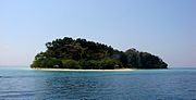 ദേശീയോദ്യാനത്തിലെ ഇരുപതു ദ്വീപുകളിൽ ഒന്നായ ജോളി ബുവോയ് ദ്വീപ്.
 -
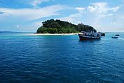 ആൻഡമാൻ ദ്വീപ്സമൂഹത്തിലെ പോർട്ട് ബ്ലയറിന് സമീപത്തെ മഹാത്മാഗാന്ധി മറൈൻ ദേശീയോദ്യാനം
 -
 സൂര്യാസ്തമയ സമയത്ത് മഹാത്മാഗാന്ധി മറൈൻ ദേശീയോദ്യാനം .


അവലംബം[തിരുത്തുക]
- ↑ "A&N Islands - Pincodes". 22 September 2016. Archived from the original on 23 March 2014. Retrieved 22 September 2016.
{{cite web}}: Unknown parameter|deadurl=ignored (|url-status=suggested) (help) - ↑ "STD Codes of Andaman and Nicobar". allcodesindia.in. Archived from the original on 2019-10-17. Retrieved 2016-09-23.
- ↑ "Sailing Directions (enroute) | India and the Bay of Bengal" (PDF) (173). National Geospatial-intelligence Agency, United States Government. 2014. Archived from the original (PDF) on 2015-04-02. Retrieved 2016-09-23.
{{cite journal}}: Cite journal requires|journal=(help) - ↑ https://www.tourmyindia.com/states/andaman/cinque-island.html