ജിബ്രാൾട്ടർ
ദൃശ്യരൂപം
ജിബ്രാൾട്ടർ | |
|---|---|
 Location of Gibraltar (dark green) – on the European continent (green & dark grey) | |
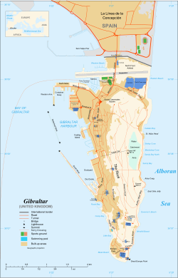
 Map of Gibraltar | |
| സ്ഥിതി | British Overseas Territory |
| തലസ്ഥാനം | Gibraltar |
| വലിയ district (by population) | Westside |
| ഔദ്യോഗിക ഭാഷകൾ | English |
| Spoken languages | |
| വംശീയ വിഭാഗങ്ങൾ |
|
| നിവാസികളുടെ പേര് | Gibraltarian Llanito (colloquial) |
| ഭരണസമ്പ്രദായം | Representative democratic parliamentary dependency under constitutional monarchy |
• Monarch | Elizabeth II |
• Governor | Sir James Dutton |
| Fabian Picardo | |
| നിയമനിർമ്മാണസഭ | Parliament |
| Formation | |
• Captured | 4 August 1704[3] |
• Ceded | 11 April 1713[4] |
| 10 September | |
• ആകെ വിസ്തീർണ്ണം | 6.8 km2 (2.6 sq mi) (241st) |
• ജലം (%) | 0 |
• 2012 estimate | 30,001 (222nd) |
• ജനസാന്ദ്രത | 4,328/km2 (11,209.5/sq mi) (5th) |
| ജി.ഡി.പി. (PPP) | 2014 estimate |
• ആകെ | £2 billion |
• പ്രതിശീർഷം | £70,400 (n/a) |
| എച്ച്.ഡി.ഐ. (2008) | 0.961[5] very high · 20th |
| നാണയവ്യവസ്ഥ | Gibraltar pound (£)c (GIP) |
| സമയമേഖല | UTC+1 (CET) |
• Summer (DST) | UTC+2 (CEST) |
| തീയതി ഘടന | dd/mm/yyyy |
| ഡ്രൈവിങ് രീതി | rightd |
| കോളിംഗ് കോഡ് | +350e |
| ISO കോഡ് | GI |
| ഇൻ്റർനെറ്റ് ഡൊമൈൻ | .gif |
| |
യുണൈറ്റഡ് കിങ്ഡത്തിന്റെ, സ്വയം ഭരണാവകാശമുള്ള ഒരു വിദേശ പ്രദേശമാണ് ജിബ്രാൾട്ടർ /dʒ[invalid input: 'ɨ']ˈbrɔːltər/ ഐബീരിയൻ ഉപദ്വീപിന്റെ തെക്കേ അറ്റത്തായി മെഡിറ്ററേനിയൻ സമുദ്രത്തിന്റെ കവാടത്തിലായി സ്ഥിതിചെയ്യുന്നു.[7][8] 6.7 km2 (2.6 sq mi) വിസ്തീർണ്ണമുള്ള ഈ പ്രദേശത്തിന്റെ വടക്കേ അതിർത്തി സ്പെയിനിലെ ആൻഡലൂഷ്യൻ പ്രോവിൻസായ കാഡിസ്(Cádiz) ആണ് . ഇവിടത്തെ ഒരു പ്രധാന അതിരടയാളമാണ് ജിബ്രാൾട്ടർ പാറ - ഇതിന് സമീപസ്ഥമായ നഗരപ്രദേശത്തിൽ 30,000 പേർ നിവസിക്കുന്നു.[9]
- ↑ "National Symbols". Gibraltar.gov.gi. Archived from the original on 2014-11-13. Retrieved 21 June 2013.
- ↑ "Gibraltar: National anthem". CIA World Factbook. Central Intelligence Agency. Archived from the original on 2020-04-23. Retrieved 25 September 2011.
National anthem: name: "Gibraltar Anthem" . . . note:adopted 1994; serves as a local anthem; as a territory of the United Kingdom, "God Save the Queen" remains official (see United Kingdom)
- ↑ Gibraltar was captured on 24 July 1704 Old Style or 4 August 1704 New Style.
- ↑ The treaty was signed on 31 March 1713 Old Style or 11 April 1713 New Style (Peace and Friendship Treaty of Utrecht between France and Great Britain).
- ↑ Filling Gaps in the Human Development Index Archived 2011-10-05 at the Wayback Machine., United Nations ESCAP, February 2009
- ↑ "Universal Postal Union document on Gibraltar" (PDF). Archived from the original (PDF) on 2016-04-13. Retrieved 2015-09-04.
- ↑ Dictionary Reference: Gibraltar
- ↑ The Free Dictionary: Gibraltar
- ↑ Statistics Office (2009). "Abstract of Statistics 2009" (PDF). Statistics Office of the Government of Gibraltar. p. 2. Archived from the original (PDF) on 2014-12-22. Retrieved 2015-09-04. The civilian population includes Gibraltarian residents, other British residents (including the wives and families of UK-based servicemen, but not the servicemen themselves) and non-British residents. Visitors and transients are not included.
In 2009, this broke down into 23,907 native-born citizens, 3,129 UK British citizens and 2,395 others, making a total population of 29,431. On census night, there were 31,623 people present in Gibraltar.


