സ്ലോവാക്യ
Slovak Republic Slovenská republika (Slovak) | |
|---|---|
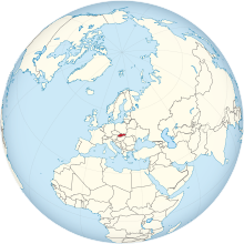
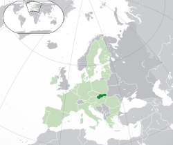
Location of സ്ലോവാക്യ (dark green) – on the European continent (green & dark grey) | |
| തലസ്ഥാനം and largest city | ബ്രാട്ടിസ്ലാവ 48°09′N 17°07′E / 48.150°N 17.117°E |
| ഔദ്യോഗിക ഭാഷകൾ | Slovak |
| വംശീയ വിഭാഗങ്ങൾ (2011[1]) |
|
| മതം (2011)[2] |
|
| നിവാസികളുടെ പേര് | Slovak |
| ഭരണസമ്പ്രദായം | Unitary parliamentary republic |
| സൂസന്ന ചപുടോവ | |
| Eduard Heger | |
| Boris Kollár | |
| നിയമനിർമ്മാണസഭ | National Council |
| Establishment history | |
• Independence from Austro-Hungarian Monarchy (First Czechoslovak Republic) | 30 October 1918 |
| 30 September 1938 | |
• Autonomous Land of Slovakia (within Second Czechoslovak Republic) | 23 November 1938 |
| 14 March 1939 | |
| 24 October 1945 | |
| 1948 | |
| 11 July 1960 | |
• Slovak Socialist Republic (within Czechoslovak Socialist Republic) | 1 January 1969 |
• Slovak Republic (change of name within established Czech and Slovak Federative Republic) | 1 March 1990 |
| 1 January 1993a | |
• Joined the European Union | 1 May 2004 |
• ആകെ വിസ്തീർണ്ണം | 49,035 km2 (18,933 sq mi) (127th) |
• ജലം (%) | 0.72 (as of 2015)[3] |
• 2020 estimate | |
• 2011 census | 5,397,036 |
• ജനസാന്ദ്രത | 111/km2 (287.5/sq mi) (88th) |
| ജി.ഡി.പി. (PPP) | 2021 estimate |
• ആകെ | |
• പ്രതിശീർഷം | |
| ജി.ഡി.പി. (നോമിനൽ) | 2021 estimate |
• ആകെ | |
• Per capita | |
| ജിനി (2018) | low · 8th |
| എച്ച്.ഡി.ഐ. (2019) | very high · 39th |
| നാണയവ്യവസ്ഥ | Euro (€) (EUR) |
| സമയമേഖല | UTC+1 (CET) |
• Summer (DST) | UTC+2 (CEST) |
| തീയതി ഘടന | dd/mm/yyyy |
| ഡ്രൈവിങ് രീതി | right |
| കോളിംഗ് കോഡ് | +421b |
| ISO കോഡ് | SK |
| ഇൻ്റർനെറ്റ് ഡൊമൈൻ | .sk and .eu |
| |
സ്ലോവാക്യ (ശരിയായ പേര് : സ്ലോവാക് റിപ്പബ്ലിക്ക്; Slovak: ⓘ, long form ⓘ) നാലു ഭാഗവും കരയാൽ ചുറ്റപ്പെട്ട ഒരു മദ്ധ്യ യൂറോപ്യൻ രാജ്യമാണ്. ഇവിടത്തെ ഏകദേശ ജനസംഖ്യ ഏതാണ്ട് 20 ലക്ഷവും വിസ്തീർണ്ണം 49,000 ചതുരശ്ര കിലോമീറ്ററുമാണ്. ഈ രാജ്യത്തിന്റെ പടിഞ്ഞാറ് ഭാഗത്ത് ചെക്ക് റിപ്പബ്ലിക്കും ,ഓസ്ട്രിയയും വടക്ക് വശത്ത് പോളണ്ടും , ഉക്രെയിൻ കിഴക്ക് വശത്തും ,തെക്ക് വശത്ത് ഹംഗറിയുമാണ്. സ്ലോവാക്യയുടെ തലസ്ഥാനം ബ്രാട്ടിസ്ലാവയാണ്. യൂറോപ്യൻ യൂനിയൻ,എൻ.എ.ടി.ഒ.(NATO),ഒ.ഇ.സി.ഡി.(OECD),ഡബ്ല്യൂ.ടി.ഒ.(WTO) എന്നീ അന്താരാഷ്ട്ര സംഘടനകളിൽ ഈ രാജ്യം അംഗമാണ്.
ഈ രാജ്യം 2004 മുതൽ യൂറോപ്യൻ യൂനിയനിലും 2009 ജനുവരി 1 മുതൽ യൂറോസോണിലും അംഗമാണ്.
സ്ലോവാക്യ 1993 ജനുവരി 1 വരെ ചെക്കോസ്ലോവാക്യയുടെ ഭാഗമായിരുന്നു, ചെക്കോസ്ലോവാക്യ വിഭജിക്കപ്പെട്ട് ചെക്ക് റിപ്പബ്ലിക്ക്, സ്ലോവാക്യ എന്നീ രാജ്യങ്ങളായിത്തീർന്നു.[8]
അവലംബം[തിരുത്തുക]
- ↑ "Tab. 10 Obyvateľstvo SR podľa národnosti – sčítanie 2011, 2001, 1991" (PDF). Portal.statistics.sk. Archived from the original (PDF) on 5 March 2016. Retrieved 21 February 2016.
- ↑ "Table 14 Population by religion" (PDF). Statistical Office of the SR. 2011. Archived from the original (PDF) on 2012-11-14. Retrieved 8 June 2012.
- ↑ "Surface water and surface water change". Organisation for Economic Co-operation and Development (OECD). Retrieved 11 October 2020.
- ↑ "Stock of population in the SR on 30th September 2020". slovak.statistics.sk. 1 June 2020.
- ↑ 5.0 5.1 5.2 5.3 "World Economic Outlook Database, October 2019". IMF.org. International Monetary Fund. Retrieved 15 January 2020.
- ↑ "Gini coefficient of equivalised disposable income - EU-SILC survey". ec.europa.eu. Eurostat. Retrieved 8 January 2020.
- ↑ Human Development Report 2020 The Next Frontier: Human Development and the Anthropocene (PDF). United Nations Development Programme. 15 December 2020. pp. 343–346. ISBN 978-92-1-126442-5. Retrieved 16 December 2020.
- ↑ http://query.nytimes.com/gst/fullpage.html?res=9E0CEED71431F93AA35753C1A964958260
അൽബേനിയ • അൻഡോറ • അർമേനിയ2 • ഓസ്ട്രിയ • അസർബെയ്ജാൻ1 • ബെലാറസ് • ബെൽജിയം • ബോസ്നിയയും ഹെർസെഗോവിനയും • ബൾഗേറിയ • ക്രൊയേഷ്യ • സൈപ്രസ്2 • ചെക്ക് റിപ്പബ്ലിക്ക് • ഡെന്മാർക്ക് • എസ്തോണിയ • ഫിൻലാന്റ് • ഫ്രാൻസ് • ജോർജ്ജിയ1 • ജെർമനി • ഗ്രീസ് • ഹങ്കറി • ഐസ്ലാന്റ് • അയർലണ്ട് • ഇറ്റലി • ഖസാക്കിസ്ഥാൻ1 • ലാത്വിയ • ലീചെൻസ്റ്റീൻ • ലിത്വാനിയ • ലക്സംബർഗ്ഗ് • മാസിഡോണിയ • മാൾട്ട • മൊൾഡോവ • മൊണാക്കോ • മോണ്ടെനെഗ്രൊ • നെതെർലാന്റ് • നോർവെ • പോളണ്ട് • പോർച്ചുഗൽ • റൊമേനിയ • റഷ്യ1 • സാൻ മരീനോ • സെർബിയ • സ്ലൊവാക്യ • സ്ലൊവേനിയ • സ്പെയിൻ • സ്വീഡൻ • സ്വിറ്റ്സർലാന്റ് • തുർക്കി1 • യുക്രെയിൻ • യുണൈറ്റഡ് കിങ്ഡം • വത്തിക്കാൻ
അംഗീകരിക്കപ്പെടാത്ത രാഷ്ട്രങ്ങൾ: അബ്ഖാസിയ • നഗോർണോ-കരബാഖ്2 • സൗത്ത് ഒസ്സെഷ്യ • ട്രാൻസ്നിസ്ട്രിയ • നോർതേൺ സൈപ്രസ്2 3
ഭൂമിശാസ്ത്ര കുറിപ്പുകൾ: (1) ഭാഗികമായി ഏഷ്യയിൽ; (2) ഏഷ്യയിൽ സ്ഥിതിചെയ്യുന്നെങ്കിലും യൂറോപ്പുമായി സാമൂഹിക-രാഷ്ട്രീയ സാമ്യങ്ങൾ ഉണ്ട്; (3) ടർക്കി മാത്രമേ വടക്കേ സൈപ്രസിനെ അംഗീകരിച്ചിട്ടുള്ളൂ.


