
ഗാബറോൺ
(ഗാബ്രോൺ എന്ന താളിൽ നിന്നും തിരിച്ചുവിട്ടതു പ്രകാരം)
Gaborone | |
|---|---|
City | |
| From top to bottom: skyline view of Gaborone, statue of Seretse Khama, the city centre of Gaborone, bird's-eye view of Gaborone From top to bottom: skyline view of Gaborone, statue of Seretse Khama, the city centre of Gaborone, bird's-eye view of Gaborone | |
| Nickname(s): Gabs, GC, Gabz, G-City, Magheba, Moshate | |
 Satellite image of Gaborone | |
 Gaborone Location of Gaborone in Botswana | |
| Coordinates: 24°39′29″S 25°54′44″E / 24.65806°S 25.91222°E | |
| Country | |
| District | Gaborone |
| Sub-district | Gaborone |
| Founded | 1964[1] |
| നാമഹേതു | Kgosi Gaborone |
| • ഭരണസമിതി | Gaborone City Council |
| • Mayor | Kagiso Thutlwe (BMD)[2] |
| • Deputy Mayor | Florence Shagwa (BCP)[2] |
| • City | [[1 E+8_m²|169 ച.കി.മീ.]] (65 ച മൈ) |
| ഉയരം | 1,014 മീ(3,327 അടി) |
(2011)[5] | |
| • City | 2,31,626 |
| • ജനസാന്ദ്രത | 1,400/ച.കി.മീ.(3,500/ച മൈ) |
| • മെട്രോപ്രദേശം | 4,21,907 |
| സമയമേഖല | UTC+2 (Central Africa Time) |
| • Summer (DST) | UTC+2 (not observed) |
| Geographical area code[6][7] | 3XX |
| ISO കോഡ് | BW-SE |
| വെബ്സൈറ്റ് | Gaborone City Council Website |
ഗാബറോൺ (English /ˌɡæbəˈroʊniː/ GAB-ə-ROH-nee) ബോട്സ്വാനയുടെ തലസ്ഥാന നഗരമാണ്. 2011 ലെ കാനേഷുമാരി പ്രകാരം 231,626 ജനസംഖ്യയുള്ള ഈ നഗരം ബോട്സ്വാനയിലെ ഏറ്റവും വലിയ നഗരമാണ് ഗബോറോൺ[5] ഇത് ബോട്സ്വാനയിലെ ആകെ ജനസംഖ്യയുടെ 10% ആണ്.[8]
കഗെയ്ൽ, ഊഡി മലകൾക്കു മദ്ധ്യത്തിൽ നൊട്ട്വൈൻ, സെഗോഡിറ്റ്ഷെയ്ൻ നദികളുടെ സംഗമസ്ഥാനത്തിനു സമീപത്തായി ബോട്സ്വാനയുടെ തെക്കു-കിഴക്കൻ മൂലയിൽ സ്ഥിതിചെയ്യുന്ന ഗാബറോൺ നഗരം, തെക്കേ ആഫ്രിക്കൻ അതിർത്തിയിൽ നിന്ന് 15 കിലോമീറ്റർ (9.3 മൈൽ) ദൂരത്തായാണ് സ്ഥിതിചെയ്യുന്നത്. സർ സെറെറ്റ്സെ ഖാമ അന്താരാഷ്ട്ര വിമാനത്താവളം ഈ നഗരത്തിന്റെ പരിധിയിലാണുള്ളത്. സ്വയം ഭരണാധികാരമുള്ള ഭരണജില്ലയായ ഇത് ചുറ്റുപാടുമായി സ്ഥിതിചെയ്യുന്ന തെക്കുകിഴക്കൻ ജില്ലയുടെ തലസ്ഥാനവുംകൂടിയാണ്. പ്രദേശവാസികൾ ഈ നഗരത്തെ "ഗാബ്സ്" എന്നു വിളിക്കുന്നു.
ചിത്രശാല[തിരുത്തുക]
-
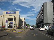 പ്രധാന മാളിന് സമീപമുള്ള തെരുവ് കാഴ്ച
 -
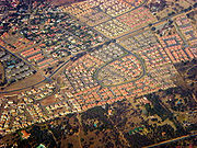 നഗരത്തിന്റെ മറ്റൊരു ആകാശക്കാഴ്ച
 -
 ദേശീയ മ്യൂസിയത്തിലെ റൊഡേഷ്യ റെയിൽവേ കാർ
 -
 കിഴക്കോട്ട് തിരഞ്ഞുള്ള നഗരത്തിന്റെ ആകാശ കാഴ്ച—നഗരകേന്ദ്രം ചിത്രത്തിന്റെ വലത് മധ്യത്തിലായും റിസർവോയർ തൊട്ടപ്പുറത്തായും കാണിച്ചിരിക്കുന്നു.
 -
ബോട്സ്വാന പാർലമെന്റ് കെട്ടിടത്തിന് പുറത്ത് സ്ഥാപിച്ചിരിക്കുന്ന ഖാമയുടെ പ്രതിമ.
-
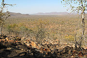 ബോട്സ്വാനയിലെ ഗാബോറോണിന് തൊട്ടപ്പുറത്തുള്ള മൊക്കോലോഡി നേച്ചർ റിസർവിന്റെ ഉയർന്ന സ്ഥാനത്തുനിന്നുള്ള കാഴ്ച,
 -
 ബോട്സ്വാന സർവ്വകലാശാലയുടെ അഡ്മിനിസ്ട്രേഷൻ കെട്ടിടം
 -
 ബോട്സ്വാന സർവകലാശാലയുടെ ഡോർമിറ്ററികൾ
 -
 ബോട്സ്വാന സർവകലാശാലാ കെട്ടിടങ്ങളും മുറ്റവും.
 -
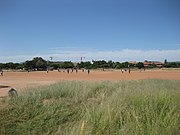 ബോട്സ്വാന യൂണിവേഴ്സിറ്റിയുടെ വിദ്യാലയപഠനത്തിലുൾപ്പെട്ട ഫുട്ബോൾ ഗെയിം.
 -
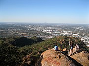 ക്ഗാലെ കുന്നിൽ നിന്ന് കാഴ്ച (ചക്രവാളത്തിൽ ഊഡി മല)
 -
 ഗാബറോൺ അണക്കെട്ട്.
 -
 ഗാബറോൺ അണക്കെട്ട്.


അവലംബം[തിരുത്തുക]
- ↑ Parsons, Neil (19 August 1999). "Botswana History Page 7: Geography". Botswana History Pages. Gaborone, Botswana: University of Botswana History Department. Retrieved 4 August 2009.
- ↑ 2.0 2.1 Keoreng, Ephraim (5 October 2011). "New Gaborone Mayor seeks power to hire and fire". 28 (148). Gaborone, Botswana: Mmegi Online. Retrieved 9 October 2011.
{{cite journal}}: Cite journal requires|journal=(help) - ↑ "BOTSWANA STATISTICAL YEAR BOOK 2010" (PDF). Statistics Botswana. Gaborone: Central Statistics Office. ഡിസംബർ 2011. Archived from the original (PDF) on 26 February 2012. Retrieved 25 February 2012.
- ↑ "Gaborone, Botswana Page". Falling Rain Genomics, Inc.
- ↑ 5.0 5.1 "The Population of Towns, Villages and Associated Localities" (PDF). 2011 Population and Housing Census. Gaborone: Statistics Botswana. ജൂൺ 2012. Archived from the original (PDF) on 2012-06-14. Retrieved 14 June 2012.
- ↑ timeanddate.com
- ↑ Botswana Telecommunications Authority (11 September 2009). Botswana (country code +267) (DOC). International Telecommunication Union. Archived from the original on 2009-12-27. Retrieved 27 December 2009.
{{cite book}}:|work=ignored (help) - ↑ Central Statistics Office (January 2009). "BOTSWANA DEMOGRAPHIC SURVEY 2006" (PDF). Gaborone, Botswana. Archived from the original (PDF) on 2016-09-23. Retrieved 3 July 2010.