
"ജമ്മു-കശ്മീർ" എന്ന താളിന്റെ പതിപ്പുകൾ തമ്മിലുള്ള വ്യത്യാസം
(ചെ.) Reverted 1 edit by 2405:204:D002:70EB:76A7:7229:A17A:A54 (talk) to last revision by Jomyalexander10. (TW) റ്റാഗ്: തിരസ്ക്കരിക്കൽ |
No edit summary |
||
| വരി 3: | വരി 3: | ||
{{prettyurl|Jammu and Kashmir}} |
{{prettyurl|Jammu and Kashmir}} |
||
{{Infobox settlement |
{{Infobox settlement |
||
| name = Jammu and Kashmir |
|||
<!-- See Template:Infobox settlement for additional fields and descriptions -->| name = ജമ്മു-കശ്മീർ |
|||
| settlement_type = [[States and union territories of India|Union Territory]] |
|||
| native_name = जोम त कशीर<br><small>جوم تِ کشیر<small> |
|||
| image_skyline = |
|||
| type = [[States of India|State of India]] |
|||
{{Photomontage |
|||
| nick name = ഇന്ത്യയുടെ പൂന്തോട്ടം |
|||
| photo1a = Rangdum village grazing fields.jpg |
|||
| image_skyline = |
|||
| photo2a = Likir Monastery. 2010.jpg |
|||
| image_alt = |
|||
| photo2b = Karakoram-West Tibetan Plateau alpine steppe.jpg |
|||
| image_caption = |
|||
| photo3a = Leisure Leh Ladakh.jpg |
|||
| image_flag = |
|||
| color = transparent |
|||
| image_seal = Seal of Jammu and Kashmir color.png |
|||
| |
| border = 0 |
||
| |
| size = 300 |
||
}} |
|||
| map_alt = |
|||
| image_alt = |
|||
| map_caption = [[ഇന്ത്യ]]യിൽ ജമ്മു-കശ്മീരിന്റെ സ്ഥാനം |
|||
| image_caption = ''Clockwise from top'': [[Rangdum|Rangdum village]]; [[Tso Moriri]]; [[Leh|Leh city]] and [[Likir Monastery]] |
|||
| image_map1 = Kashmir map.svg |
|||
| image_flag = Jammu-Kashmir-flag.svg |
|||
| map_caption1 = ജമ്മു-കശ്മീരിന്റെ ഭൂപടം |
|||
| image_seal = Seal of Jammu and Kashmir color.png |
|||
| latd = 33.45 |
|||
| seal_alt = Seal |
|||
| longd = 76.24 |
|||
| image_map = IN-JK.svg |
|||
| coor_pinpoint = ശ്രീനഗർ |
|||
| map_alt = Jammu and Kashmir |
|||
| coordinates_type = region:IN-JK_type:adm1st |
|||
| map_caption = Location of Jammu and Kashmir in India |
|||
| coordinates_display = inline,title |
|||
| image_map1 = Kashmir_region_2004.jpg |
|||
| coordinates_footnotes = |
|||
| map_caption1 = Map of Jammu and Kashmir |
|||
| coordinates_region = IN-JK |
|||
| coordinates = {{coord|33.45|76.24|region:IN-JK_type:adm1st|display=inline,title}} |
|||
| subdivision_type = Country |
|||
| coor_pinpoint = Srinagar |
|||
| subdivision_name = {{IND}} |
|||
| coordinates_footnotes = |
|||
| established_title = Established |
|||
| subdivision_type = Country |
|||
| established_date = 26 October 1947 |
|||
| subdivision_name = {{flag|India}} |
|||
| parts_type = [[List of Indian districts|Districts]] |
|||
| established_title = Admission to Union |
|||
| parts_style = para |
|||
| established_date = 26 October 1947 |
|||
| p1 = 22 |
|||
| seat_type = Capital |
| seat_type = Capital |
||
| seat = [[Srinagar]] (May–October)<br/> [[Jammu]] (Nov-April)<ref name="Darbar Move">{{Cite news |url=https://www.thehindu.com/news/national/other-states/what-is-the-darbar-move-in-j-k-all-about/article18409452.ece |title=What is the Darbar Move in J&K all about? |last=Desk |first=The Hindu Net |date=2017-05-08 |newspaper=The Hindu |language=en-IN |access-date=2019-02-23 |archive-url=https://web.archive.org/web/20171110135648/http://www.thehindu.com/news/national/other-states/what-is-the-darbar-move-in-j-k-all-about/article18409452.ece |archive-date=10 November 2017 |dead-url=no |df=dmy-all }}</ref> |
|||
| seat = * [[ജമ്മു]] (മഞ്ഞുകാലം) |
|||
| parts_type = [[List of districts in Jammu and Kashmir|Districts]] |
|||
* [[ശ്രീനഗർ]] (വേനൽക്കാലം) |
|||
| parts_style = para |
|||
| seat1_type = Largest city |
|||
| p1 = [[List of districts in Jammu and Kashmir|22]] |
|||
| seat1 = ശ്രീനഗർ |
|||
| government_footnotes = {{ref|leg|[*]}} |
| government_footnotes = {{ref|leg|[*]}} |
||
| governing_body = |
|||
| leader_title = [[Governors of Jammu and Kashmir|Governor]] |
|||
| leader_title = [[Governors of Jammu and Kashmir|Governor]] |
|||
| leader_name = [[നരീന്ദർ നാഥ് വോറ]] |
|||
| leader_name = [[Satya Pal Malik]]<ref>{{cite news |title=Satya Pal Malik sworn in as Jammu and Kashmir governor |url=https://economictimes.indiatimes.com/news/politics-and-nation/satya-pal-malik-sworn-in-as-jammu-and-kashmir-governor/articleshow/65512757.cms |work=The Economic Times |agency=Press Trust of India |date=23 August 2018 |access-date=31 August 2018 |archive-url=https://web.archive.org/web/20180823110106/https://economictimes.indiatimes.com/news/politics-and-nation/satya-pal-malik-sworn-in-as-jammu-and-kashmir-governor/articleshow/65512757.cms |archive-date=23 August 2018 |dead-url=no |df=dmy-all }}</ref> |
|||
| leader_title1 = [[List of Prime and Chief Ministers of Jammu and Kashmir|Chief Minister]] |
|||
| leader_title1 = [[Chief Ministers of Jammu and Kashmir|Chief Minister]] |
|||
| leader_name1 = [[മെഹബൂബ മുഫ്തി]]<small>(നിർദ്ദേശിക്കപ്പെട്ടിരിക്കുന്നു)</small>, ([[പീപ്പിൾസ് ഡെമോക്രാറ്റിക് പാർട്ടി (ജമ്മു കശ്മീർ)|പി.ഡി.പി]]) |
|||
| leader_name1 = [[Governor's rule|''Vacant'']]<ref>{{cite web|url=https://www.firstpost.com/politics/bjp-pdp-alliance-ends-in-jammu-and-kashmir-live-updates-modi-govt-did-everything-to-normalise-situation-says-ram-madhav-4542011.html|title=BJP-PDP alliance ends in Jammu and Kashmir LIVE updates: Mehbooba Mufti resigns as chief minister; Governor's Rule in state|work=[[Firstpost]]|accessdate=19 June 2018|date=19 June 2018}}</ref> |
|||
| leader_title2 = [[Jammu and Kashmir Legislature|Legislature]] |
|||
| unit_pref = Metric |
|||
| leader_name2 = [[Bicameralism|Bicameral]] (89 + 36 seats) |
|||
| area_footnotes = |
|||
| unit_pref = Metric |
|||
| area_total_km2 = 222236 |
|||
| area_footnotes = |
|||
| area_rank = [[List of states and territories of India by area|5th]]<ref name="short100sqkm" group="note">Jammu and Kashmir is a [[disputed territory]] between [[India]], [[Pakistan]] and [[China]]. The areas of [[Azad Kashmir]] and [[Gilgit-Baltistan]] administered by Pakistan and [[Aksai Chin]] region administered by [[China]] are included in the total area.</ref> |
|||
| area_total_km2 = 222236 |
|||
| elevation_max_footnotes =<ref>{{Cite web|url=http://publications.americanalpineclub.org/articles/12197506500/Saser-Kangri|title=Saser Kangri - AAC Publications - Search The American Alpine Journal and Accidents|website=publications.americanalpineclub.org|access-date=2019-02-14|archive-url=https://web.archive.org/web/20190214115923/http://publications.americanalpineclub.org/articles/12197506500/Saser-Kangri|archive-date=14 February 2019|dead-url=no|df=dmy-all}}</ref> |
|||
| area_note = |
|||
| elevation_max_m = 7,672 |
|||
| area_rank = [[List of states and territories of India by area|6th]] |
|||
| elevation_max_ft = |
|||
| elevation_footnotes = |
|||
| elevation_max_point = <!-- for denoting the measurement point --> |
|||
| elevation_m = 327 |
|||
| elevation_max_rank = |
|||
| population_footnotes = |
|||
| elevation_min_footnotes =<ref name="Lowest elevation">{{Cite web |url=http://www.koausa.org/Geography/ch1.6.html |title=Climate Patterns and Climatic Divisions |last=Raina |first=A.N |access-date=5 June 2018 |archive-url=https://web.archive.org/web/20180616224706/http://www.koausa.org/Geography/ch1.6.html |archive-date=16 June 2018 |dead-url=no |df=dmy-all }}</ref> |
|||
| population_total = 12548926 |
|||
| elevation_min_m = 300 |
|||
| population_as_of = 2011 |
|||
| elevation_min_ft = |
|||
| population_rank = [[List of states and union territories of India by population|18th]] |
|||
| elevation_min_point = <!-- for denoting the measurement point --> |
|||
| population_density_km2 = 56 |
|||
| elevation_min_rank = |
|||
| population_note = |
|||
| population_total = 12541302 |
|||
| timezone1 = [[Indian Standard Time|IST]] |
|||
| population_as_of = 2011 |
|||
| utc_offset1 = +05:30 |
|||
| population_footnotes = |
|||
| iso_code = [[ISO 3166-2:IN|IN-JK]] |
|||
| population_density_km2 = 56 |
|||
| unemployment_rate = |
|||
| population_rank = [[List of states and union territories of India by population|19th]] |
|||
| blank_name_sec1 = [[Human Development Index|HDI]] |
|||
| population_note = |
|||
| blank_info_sec1 = {{increase}} 0.601 (<span style="color:#fc0">medium</span>) |
|||
| timezone1 = [[Indian Standard Time|IST]] |
|||
| blank1_name_sec1 = HDI rank |
|||
| utc_offset1 = +05:30 |
|||
| blank1_info_sec1 = 17th (2005) |
|||
| iso_code = [[ISO 3166-2:IN|IN-JK]] |
|||
| blank_name_sec2 = [[Literacy in India|Literacy]] |
|||
| unemployment_rate = |
|||
| blank_info_sec2 = 66.7% (21st) |
|||
| blank_name_sec1 = [[List of Indian states and territories by Human Development Index|HDI]] |
|||
| blank1_name_sec2 = Official language |
|||
| blank_info_sec1 = {{increase}} 0.684<ref name="snhdi-gdl">{{cite web |title=Sub-national HDI – Area Database |url=https://hdi.globaldatalab.org/areadata/shdi/ |website=Global Data Lab |publisher=Institute for Management Research, Radboud University |accessdate=25 September 2018 |language=en |archive-url=https://web.archive.org/web/20180923120638/https://hdi.globaldatalab.org/areadata/shdi/ |archive-date=23 September 2018 |dead-url=no |df=dmy-all }}</ref> (<span style="color:#FFA500">medium</span>) |
|||
| blank1_info_sec2 = [[കശ്മീരി ഭാഷ|കശ്മീരി]], [[ഉർദു]] |
|||
| blank1_name_sec1 = HDI rank |
|||
| blank2_name_sec2 = Other languages |
|||
| blank1_info_sec1 = [[List of Indian states and territories by Human Development Index|17th]] (2017) |
|||
| blank2_info_sec2 = [[Dogri language|ദോഗ്രി]], [[ഹിന്ദി]], [[Indian English|ഇംഗ്ലീഷ്]], [[Ladakhi language|ലഡാക്കി]] |
|||
| blank_name_sec2 = [[Literacy in India|Literacy]] |
|||
| website = {{URL|www.jammukashmir.nic.in}} |
|||
| blank_info_sec2 = 68.74 (30th) |
|||
| footnotes = |
|||
| blank1_name_sec2 = {{nowrap|[[Official languages]]}} |
|||
| blank1_info_sec2 = [[Urdu]]<ref name=langoff50>{{cite web|url=http://nclm.nic.in/shared/linkimages/NCLM50thReport.pdf |title=Report of the Commissioner for linguistic minorities: 50th report (July 2012 to June 2013) |publisher=Commissioner for Linguistic Minorities, Ministry of Minority Affairs, Government of India |page=49 |accessdate=14 January 2015 |deadurl=yes |archiveurl=https://web.archive.org/web/20160708012438/http://nclm.nic.in/shared/linkimages/NCLM50thReport.pdf |archivedate= 8 July 2016 |df= }}</ref> |
|||
| website = {{URL|jk.gov.in/}} |
|||
| footnotes = |
|||
| seat1_type = |
|||
| seat1 = |
|||
| leader_title2 = [[Jammu and Kashmir Legislature|Legislature]] |
|||
| leader_name2 = [[Bicameralism|Bicameral]] (87 seats in the [[Jammu and Kashmir Legislative Assembly|Assembly]] + 36 seats in the [[Jammu and Kashmir Legislative Council|Council]]), (Currently Assembly is Dissolved by the [[Governor of Jammu and Kashmir|Governor of J&K]]) |
|||
| leader_title3 = [[15th Lok Sabha|Parliamentary constituency]] |
|||
| leader_name3 = [[Rajya Sabha]] (4) <br /> [[Lok Sabha]] (6) |
|||
| leader_title4 = [[High Courts of India|High Court]] |
|||
| leader_name4 = [[Jammu and Kashmir High Court]] |
|||
| blank2_name_sec2 = Other spoken |
|||
| blank2_info_sec2 = [[Kashmiri language|Kashmiri]], [[Hindi]], [[Dogri language|Dogri]], [[Punjabi language|Punjabi]], [[Pahari language (JK)|Pahari]], [[Gujari language|Gojri]], [[Balti language|Balti]], Dadri, [[Ladakhi language|Ladakhi]]<ref name=langoff50/><ref name="Languages">{{Cite book |url=https://books.google.co.in/books?id=RRbIAAAAQBAJ&lpg=PP1&pg=PA184#v=onepage&q&f=false |title=The Parchment of Kashmir: History, Society, and Polity |last=Khan |first=N. |date=2012-08-06 |publisher=Springer |isbn=9781137029584 |page=184 |language=en |access-date=23 February 2019 |archive-url=https://web.archive.org/web/20190223184947/https://books.google.co.in/books?id=RRbIAAAAQBAJ&lpg=PP1&pg=PA184#v=onepage&q&f=false |archive-date=23 February 2019 |dead-url=no |df=dmy-all }}</ref><ref name="Dadri">{{Cite book |url=https://books.google.co.in/books?id=XNqOjvaAb9cC&lpg=PP1&pg=PA6#v=onepage&q&f=false |title=Modern History of Jammu and Kashmir: Ancient times to Shimla Agreement |last=Aggarwal |first=J. C. |last2=Agrawal |first2=S. P. |date=1995 |publisher=Concept Publishing Company |isbn=9788170225577 |language=en |access-date=23 February 2019 |archive-url=https://web.archive.org/web/20190224001711/https://books.google.co.in/books?id=XNqOjvaAb9cC&lpg=PP1&pg=PA6#v=onepage&q&f=false |archive-date=24 February 2019 |dead-url=no |df=dmy-all }}</ref> [[Zangskari]],<ref>{{Cite encyclopedia |title=Zangskari |url=http://www.ethnologue.com/language/zau |language=en}}</ref> [[Bhadarwahi]],<ref>{{Cite encyclopedia |title=Bhadrawahi |url=http://www.ethnologue.com/language/bhd |language=en}}</ref> [[Purgi language|Purgi]],<ref>{{Cite encyclopedia |title=Purik |url=http://www.ethnologue.com/language/prx |language=en}}</ref> [[Standard Tibetan|Tibetan]],<ref>{{Cite encyclopedia |title=Tibetan (Bhoti)—An Endangered Script in Trans-Himalaya |encyclopedia=The Tibet Journal |last=Shakspo |first=Nawang Tsering |date=2005 |volume=30 |issue=1 |pages=61–64 |issn=0970-5368|jstor=43301113 |publisher=Library of Tibetan Works and Archives }}</ref> [[Bateri language|Bateri]],<ref>{{Cite encyclopedia |title=Bateri |url=http://www.ethnologue.com/language/btv |language=en}}</ref> [[Shina language|Shina]],<ref name="Crane1956">{{cite book|last=Crane|first=Robert I.|title=Area Handbook on Jammu and Kashmir State|year=1956|publisher=University of Chicago for the Human Relations Area Files|language=English|page=179|quote=Shina is the most eastern of these languages and in some of its dialects such as the Brokpa of Dah and Hanu and the dialect of Dras, it impinges upon the area of the Sino-Tibetan language family and has been affected by Tibetan with an overlay of words and idioms.}}</ref> [[Burushaski]],<ref>{{Cite encyclopedia |title=Pakistan's "Burushaski" Language Finds New Relatives |url=https://www.npr.org/2012/06/20/155454736/pakistans-burushaski-language-finds-new-relatives |language=en}}</ref> [[Brokskat]]<ref>{{Cite encyclopedia |title=Brokskat |url=http://www.ethnologue.com/language/bkk |language=en}}</ref> and [[Khowar language|Khowar]]<ref name="SimonsFenning2017">{{cite book|last1=Simons|first1= Gary F. |last2=Fennig|first2=Charles D. |title=Ethnologue: Languages of the World, Twentieth Edition|year=2017|publisher=[[SIL International]]|location= Dallas|language=English}}</ref> |
|||
| demographics_type1 = GDP |
|||
| demographics1_footnotes = <ref name="GDP 2018-19">{{Cite web |url=https://www.prsindia.org/parliamenttrack/budgets/jammu-and-kashmir-budget-analysis-2018-19 |title=Jammu and Kashmir Budget Analysis 2018-19 |date=2018-01-19 |website=PRSIndia |language=en |access-date=2019-02-24 |archive-url=https://web.archive.org/web/20190224173809/https://www.prsindia.org/parliamenttrack/budgets/jammu-and-kashmir-budget-analysis-2018-19 |archive-date=24 February 2019 |dead-url=no |df=dmy-all }}</ref> |
|||
| demographics1_title1 = [[List of Indian states and union territories by GDP|Total]] {{nobold|(2018–19)}} |
|||
| demographics1_info1 = {{INRConvert|1.16|lc}} |
|||
}} |
|||
{{Infobox region symbols |
|||
| state = Jammu and Kashmir |
|||
| country = India |
|||
| bird = [[File:Grus nigricollis -Bronx Zoo-8-3c.jpg|50px|left]] [[Black-necked crane]] |
|||
| animal = [[File:Cervus cashmeerianus Smit.jpg|50px|left]] [[Kashmir stag]] |
|||
| flower = [[File:Sacred_lotus_Nelumbo_nucifera.jpg|50px|left]] [[Lotus flower|Lotus]] |
|||
| tree = [[File:Platanus orientalis tree.JPG|50px|left]] [[Chinar tree]] |
|||
}} |
}} |
||
10:21, 5 ഓഗസ്റ്റ് 2019-നു നിലവിലുണ്ടായിരുന്ന രൂപം
Jammu and Kashmir | ||||||
|---|---|---|---|---|---|---|
| ||||||
| ||||||
.svg) Location of Jammu and Kashmir in India | ||||||
 Map of Jammu and Kashmir | ||||||
| Coordinates (Srinagar): 33°27′N 76°14′E / 33.45°N 76.24°E | ||||||
| Country | ||||||
| Admission to Union | 26 October 1947 | |||||
| Capital | Srinagar (May–October) Jammu (Nov-April)[1] | |||||
| Districts | 22 | |||||
| • Governor | Satya Pal Malik[2] | |||||
| • Chief Minister | Vacant[3] | |||||
| • Legislature | Bicameral (87 seats in the Assembly + 36 seats in the Council), (Currently Assembly is Dissolved by the Governor of J&K) | |||||
| • Parliamentary constituency | Rajya Sabha (4) Lok Sabha (6) | |||||
| • High Court | Jammu and Kashmir High Court | |||||
| • ആകെ | 2,22,236 ച.കി.മീ.(85,806 ച മൈ) | |||||
| •റാങ്ക് | 5th[note 1] | |||||
| ഉയരത്തിലുള്ള സ്ഥലം | 7,672 മീ(25,171 അടി) | |||||
| താഴ്ന്ന സ്ഥലം | 300 മീ(1,000 അടി) | |||||
(2011) | ||||||
| • ആകെ | 1,25,41,302 | |||||
| • റാങ്ക് | 19th | |||||
| • ജനസാന്ദ്രത | 56/ച.കി.മീ.(150/ച മൈ) | |||||
| • Total (2018–19) | ₹1.16 ലക്ഷം കോടി (US$18 billion) | |||||
| സമയമേഖല | UTC+05:30 (IST) | |||||
| ISO കോഡ് | IN-JK | |||||
| HDI | ||||||
| HDI rank | 17th (2017) | |||||
| Literacy | 68.74 (30th) | |||||
| Official languages | Urdu[8] | |||||
| Other spoken | Kashmiri, Hindi, Dogri, Punjabi, Pahari, Gojri, Balti, Dadri, Ladakhi[8][9][10] Zangskari,[11] Bhadarwahi,[12] Purgi,[13] Tibetan,[14] Bateri,[15] Shina,[16] Burushaski,[17] Brokskat[18] and Khowar[19] | |||||
| വെബ്സൈറ്റ് | jk | |||||


.svg)

| Animal |  |
|---|---|
| Bird |  |
| Flower |  |
| Tree |  |
ജമ്മു-കശ്മീർ (ദോഗ്രി: जम्मू और कश्मीर; ഉറുദു: مقبوضہ کشمیر) ) ഇന്ത്യയുടെ വടക്കേ അതിർത്തി സംസ്ഥാനമാണ്. ഹിമാലയൻ പർവതനിരകളിലും താഴ്വാരങ്ങളിലുമായി വ്യാപിച്ചുകിടക്കുന്ന സംസ്ഥാനമാണിത്. തെക്ക് ഹിമാചൽ പ്രദേശ്, പടിഞ്ഞാറ് പാകിസ്താൻ, വടക്കും കിഴക്കും ചൈന എന്നിവയാണ് ജമ്മു-കാശ്മീരിന്റെ അതിർത്തികൾ. ജമ്മു, കശ്മീർ, ലഡാക് എന്നിങ്ങനെ മൂന്നു പ്രദേശങ്ങളുടെ സഞ്ചയമാണീ സംസ്ഥാനം. വേനൽക്കാലത്ത് ശ്രീനഗറും മഞ്ഞുകാലത്ത് ജമ്മുവുമാണ് തലസ്ഥാനം. മനോഹരങ്ങളായ തടാകങ്ങളും മഞ്ഞു മലകളും പച്ചതാഴ്വാരങ്ങളും നിറഞ്ഞ ഈ പ്രദേശം ഇന്ത്യയിലെ ഏറ്റവും പ്രകൃതിരമണീയമായ സംസ്ഥാനങ്ങളിലൊന്നാണ്[20].
ഇന്ത്യ സ്വതന്ത്രമായതിനുശേഷം ഏറ്റവുമേറെ വിവാദങ്ങളുണ്ടാക്കിയ ഭൂപ്രദേശമാണിത്. ഇന്ത്യ, പാകിസ്താൻ, ചൈന എന്നീ മൂന്നു രാജ്യങ്ങളുൾപ്പെടുന്ന തർക്കപ്രദേശമെന്ന നിലയിലും ഇതിന്റെ ഫലമായുള്ള സംഘർഷങ്ങളുടെ പേരിലും രാജ്യാന്തര ശ്രദ്ധയാകർഷിക്കുന്നു. ജമ്മു-കാശ്മീരിനെ ഇന്ത്യ അതിന്റെ അവിഭാജ്യ ഘടകമായി കരുതുന്നു. എന്നാൽ ഈ ഭൂപ്രദേശത്തിന്റെ പകുതിയോളമേ ഇന്ത്യയുടെ നേരിട്ടുള്ള നിയന്ത്രണത്തിലുള്ളൂ. ഭരണഘടനയുടെ 370ആം അനുച്ഛേദപ്രകാരം ഇന്ത്യയിൽ പ്രത്യേക പരിഗണനകളുള്ള സംസ്ഥാനമാണിത്. എന്നാൽ ജമ്മു-കാശ്മീരിന്റെ മേലുള്ള ഇന്ത്യയുടെ അവകാശവാദത്തെ അയൽ രാജ്യങ്ങളായ പാകിസ്താനും ചൈനയും വർഷങ്ങളായി എതിർക്കുന്നു. വടക്കു പടിഞ്ഞാറുള്ള പ്രദേശങ്ങൾ പാകിസ്താന്റെ നിയന്ത്രണത്തിലുമാണ്. ഇന്ത്യ ഈ പ്രദേശത്തെ പാക്ക് അധിനിവേശ കശ്മീർ എന്നു വിശേഷിപ്പിക്കുന്നു. കിഴക്കുഭാഗത്തുള്ള അക്സായി ചിൻ പ്രദേശം ചൈനയുടെ നിയന്ത്രണത്തിലുമാണ്. ഇവയ്ക്കൊക്കെ പുറമേ സ്വതന്ത്ര കാശ്മീരിനായി പോരാടുന്ന തീവ്രവാദ സംഘങ്ങളും ഇവിടെ സജീവമാണ്. ചുരുക്കത്തിൽ അതിർത്തി തർക്കങ്ങളും വിഘടനവാദ പ്രവർത്തനങ്ങളും സൈനിക കടന്ന് കയറ്റങ്ങളും മൂലം ഇന്ത്യയിലെ ഏറ്റവും അരക്ഷിതമായ പ്രദേശമായി മാറിയിട്ടുണ്ട് ഈ സംസ്ഥാനം.
ചരിത്രം
ഇന്ത്യ-പാകിസ്താൻ വിഭജനകാലത്ത് സ്വതന്ത്രമായി നിന്ന പ്രദേശം ആണ് കാശ്മീർ. പിന്നാലെ പാകിസ്താൻ അവരുടെ കൂടെ ചേർക്കുന്നതിന് കാശ്മീരിൽ സൈനിക മുന്നേറ്റം നടത്തി മൂന്നിലൊന്ന് പ്രദേശം കൈവശപ്പെടുത്തി. അപ്പോൾ കശ്മീർ മഹാരാജാവ് ഇന്ത്യയുടെ സഹായം തേടുകയും ഇന്ത്യയിൽ ലയിക്കാൻ സമ്മതിക്കുകയും ചെയ്തു. അപ്പോൾ മാത്രം ആണ് ഇന്തൃൻ സൈനൃം കാശ്മീരിൽ പ്രവേശിച്ച് പാകിസ്താനുമായി യുദ്ധം ചെയ്തതും. പക്ഷെ പാകിസ്താൻ പിടിച്ചെടുത്ത പ്രദേശം തിരിച്ചു പിടിക്കാൻ ഇന്ത്യക്ക് പറ്റിയില്ല . ഇത് പാക് അധിനിവേശ കാശ്മീർ എന്നറിയപ്പെട്ടു. പാകിസ്താൻ ഗവൺമെന്റ് ഇതിന്റെ സ്വയംഭരണാവകാശം ഉണ്ട് എന്ന് പ്രഖ്യപിച്ചു കൊണ്ട് ഇന്ത്യയുമായി 1947,1965 യുദ്ധം ചെയ്യുകയുണ്ടായി. രണ്ടു യുദ്ധത്തിലും പാകിസ്താൻ പരാജിതരായി. (പക്ഷെ പോയത് പോയി). ഇതിനെ തുടർന്ന് പാകിസ്താനിനെ തീവ്രവാദികൾ ഭൂരിഭാഗ ജനവിഭാഗമായ കാശ്മീരിലെ മുസ്ലീം ജനതയെ മതവികാരത്തിന്റെ പേരിൽ ഇളക്കിവിടുകയും തീവ്രവാദി സംഘടകൾ ഉണ്ടാക്കുകയും, കാശ്മീരിലെ ജനജീവിതം ദുസ്സഹകമാക്കുകയും കുട്ടകൊലകൾ നടത്തുകയും ചെയ്തു. 1985 സിയാച്ചിനിൽ നുഴഞ്ഞുകയറ്റം നടത്തിയ പാകിസ്താൻ സേനക്കെതിരെ ഇന്ത്യ ശക്തമായി പ്രതിരോധിക്കുകയും ഒരു യൂദ്ധത്തിന്റെ വക്കിൽ എത്തുകയും ചെയ്തു. അതിനുശേഷം 1999ൽ പാകിസ്താൻ സൈന്യം വീണ്ടും കാർഗിലിൽ നുഴഞ്ഞു കയറുകയും ഇന്ത്യയുമായി യുദ്ധത്തിൽ എത്തുകയും ചെയ്റ്റു. യുദ്ധാവസാനം പാകിസ്താൻ സേനയെ തുരത്തി ഓടിക്കുകയും കാർഗിൽ കീഴടക്കുകയും ചെയ്തു
-
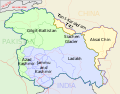 ജമ്മു-കശ്മീർ - ഭൂപടം
 -
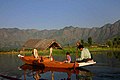 ശ്രീനഗറിലെ ദാൽ തടാകം


പ്രത്യേക പദവി
2019 ഓഗസ്റ്റ് അഞ്ചു വരെ ഇന്ത്യൻ യൂണിയനിൽ പ്രത്യേക പദവിയുള്ള സംസ്ഥാനമായിരുന്നു ജമ്മു കശ്മീർ. ജമ്മു കശ്മീരിനു പ്രത്യേക പദവി നൽകുന്ന ഭരണഘടനയുടെ 370ാം അനുച്ഛേദം റദ്ദാക്കി രാഷ്ട്രപതി റാംനാഥ് കോവിന്ദാണ് ഉത്തരവിറക്കിയത്. ബിജെപിയുടെ തിരഞ്ഞെടുപ്പ് വാഗ്ദാനമായിരുന്നു സംസ്ഥാനത്തിൻറെ പ്രത്യേക പദവി ഒഴിവാക്കും എന്നത്. ആഭ്യന്തരമന്ത്രി അമിത് ഷായുടെ പാർലമെൻറിലെ പ്രഖ്യാപനത്തിനെതിരെ കോൺഗ്രസ് അടക്കമുള്ള വിവിധ രാഷ്ട്രീയ പാർട്ടികൾ പ്രതിഷേധവുമായി രംഗത്തെത്തിയിരുന്നു.
ഇന്ത്യൻ ഭരണഘടനയുടെ 370-ആം വകുപ്പനുസരിച്ച് പ്രതിരോധം, വാർത്താവിനിമയം, വിദേശകാര്യം എന്നീ മേഖലകളിലൊഴികെ ഇന്ത്യൻ പാർലമെന്റ് പാസ്സാക്കുന്ന നിയമങ്ങൾ ജമ്മു-കശ്മീരിന് ബാധകമാകണമെങ്കിൽ സംസ്ഥാന സർക്കാരിന്റെ അംഗീകാരം ആവശ്യമായിരുന്നു
അവലംബം
- ↑ Desk, The Hindu Net (8 മേയ് 2017). "What is the Darbar Move in J&K all about?". The Hindu (in Indian English). Archived from the original on 10 നവംബർ 2017. Retrieved 23 ഫെബ്രുവരി 2019.
{{cite news}}: Unknown parameter|dead-url=ignored (|url-status=suggested) (help) - ↑ "Satya Pal Malik sworn in as Jammu and Kashmir governor". The Economic Times. Press Trust of India. 23 ഓഗസ്റ്റ് 2018. Archived from the original on 23 ഓഗസ്റ്റ് 2018. Retrieved 31 ഓഗസ്റ്റ് 2018.
{{cite news}}: Unknown parameter|dead-url=ignored (|url-status=suggested) (help) - ↑ "BJP-PDP alliance ends in Jammu and Kashmir LIVE updates: Mehbooba Mufti resigns as chief minister; Governor's Rule in state". Firstpost. 19 June 2018. Retrieved 19 June 2018.
- ↑ "Saser Kangri - AAC Publications - Search The American Alpine Journal and Accidents". publications.americanalpineclub.org. Archived from the original on 14 ഫെബ്രുവരി 2019. Retrieved 14 ഫെബ്രുവരി 2019.
{{cite web}}: Unknown parameter|dead-url=ignored (|url-status=suggested) (help) - ↑ Raina, A.N. "Climate Patterns and Climatic Divisions". Archived from the original on 16 ജൂൺ 2018. Retrieved 5 ജൂൺ 2018.
{{cite web}}: Unknown parameter|dead-url=ignored (|url-status=suggested) (help) - ↑ "Jammu and Kashmir Budget Analysis 2018-19". PRSIndia (in ഇംഗ്ലീഷ്). 19 ജനുവരി 2018. Archived from the original on 24 ഫെബ്രുവരി 2019. Retrieved 24 ഫെബ്രുവരി 2019.
{{cite web}}: Unknown parameter|dead-url=ignored (|url-status=suggested) (help) - ↑ "Sub-national HDI – Area Database". Global Data Lab (in ഇംഗ്ലീഷ്). Institute for Management Research, Radboud University. Archived from the original on 23 സെപ്റ്റംബർ 2018. Retrieved 25 സെപ്റ്റംബർ 2018.
{{cite web}}: Unknown parameter|dead-url=ignored (|url-status=suggested) (help) - ↑ 8.0 8.1 "Report of the Commissioner for linguistic minorities: 50th report (July 2012 to June 2013)" (PDF). Commissioner for Linguistic Minorities, Ministry of Minority Affairs, Government of India. p. 49. Archived from the original (PDF) on 8 July 2016. Retrieved 14 January 2015.
{{cite web}}: Unknown parameter|deadurl=ignored (|url-status=suggested) (help) - ↑ Khan, N. (6 ഓഗസ്റ്റ് 2012). The Parchment of Kashmir: History, Society, and Polity (in ഇംഗ്ലീഷ്). Springer. p. 184. ISBN 9781137029584. Archived from the original on 23 ഫെബ്രുവരി 2019. Retrieved 23 ഫെബ്രുവരി 2019.
{{cite book}}: Unknown parameter|dead-url=ignored (|url-status=suggested) (help) - ↑ Aggarwal, J. C.; Agrawal, S. P. (1995). Modern History of Jammu and Kashmir: Ancient times to Shimla Agreement (in ഇംഗ്ലീഷ്). Concept Publishing Company. ISBN 9788170225577. Archived from the original on 24 ഫെബ്രുവരി 2019. Retrieved 23 ഫെബ്രുവരി 2019.
{{cite book}}: Unknown parameter|dead-url=ignored (|url-status=suggested) (help) - ↑ Zangskari (in ഇംഗ്ലീഷ്).
- ↑ Bhadrawahi (in ഇംഗ്ലീഷ്).
- ↑ Purik (in ഇംഗ്ലീഷ്).
- ↑ Shakspo, Nawang Tsering (2005). "Tibetan (Bhoti)—An Endangered Script in Trans-Himalaya". The Tibet Journal. Vol. 30. Library of Tibetan Works and Archives. pp. 61–64. ISSN 0970-5368. JSTOR 43301113.
- ↑ Bateri (in ഇംഗ്ലീഷ്).
- ↑ Crane, Robert I. (1956). Area Handbook on Jammu and Kashmir State (in English). University of Chicago for the Human Relations Area Files. p. 179.
Shina is the most eastern of these languages and in some of its dialects such as the Brokpa of Dah and Hanu and the dialect of Dras, it impinges upon the area of the Sino-Tibetan language family and has been affected by Tibetan with an overlay of words and idioms.
{{cite book}}: CS1 maint: unrecognized language (link) - ↑ Pakistan's "Burushaski" Language Finds New Relatives (in ഇംഗ്ലീഷ്).
- ↑ Brokskat (in ഇംഗ്ലീഷ്).
- ↑ Simons, Gary F.; Fennig, Charles D. (2017). Ethnologue: Languages of the World, Twentieth Edition (in English). Dallas: SIL International.
{{cite book}}: CS1 maint: unrecognized language (link) - ↑ "സോനാമാർഗിലെ പ്രഭാതം" (PDF). മലയാളം വാരിക. 2012 ഒക്റ്റോബർ 12. Retrieved 2013 ഫെബ്രുവരി 11.
{{cite news}}: Check date values in:|accessdate=and|date=(help)

|
| |||
ഇതും കാണുക
|
ജമ്മു-കശ്മീരിന്റെ ഭൂമിശാസ്ത്രവുമായി ബന്ധപ്പെട്ട ഈ ലേഖനം അപൂർണ്ണമാണ്. ഇതു വികസിപ്പിക്കുവാൻ സഹായിക്കുക. |
ഉദ്ധരിച്ചതിൽ പിഴവ്: <ref> റ്റാഗുകൾ "note" സംഘത്തിൽ ഉണ്ട്, പക്ഷേ ബന്ധപ്പെട്ട <references group="note"/> റ്റാഗ് കണ്ടെത്താനായില്ല