ഹണ്ട് കൗണ്ടി (ടെക്സസ്)
ദൃശ്യരൂപം
| Hunt County, Texas | |
|---|---|
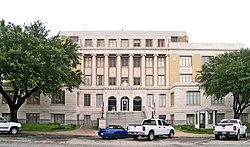
 ഗീൻവില്ലിലെ ഹണ്ട് കൗണ്ടി കോർട്ട്ഹൗസ് | |
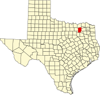
 Location in the U.S. state of Texas | |
 Texas's location in the U.S. | |
| സ്ഥാപിതം | 1846 |
| Named for | മെമുക്കൻ ഹണ്ട് ജൂണിയർ |
| സീറ്റ് | ഗ്രീൻവിൽ |
| വലിയ പട്ടണം | ഗ്രീൻവിൽ |
| വിസ്തീർണ്ണം | |
| • ആകെ. | 882 ച മൈ (2,284 കി.m2) |
| • ഭൂതലം | 840 ച മൈ (2,176 കി.m2) |
| • ജലം | 42 ച മൈ (109 കി.m2), 4.7% |
| ജനസംഖ്യ | |
| • (2010) | 86,129 |
| • ജനസാന്ദ്രത | 102/sq mi (39/km²) |
| Congressional district | 4ആം |
| സമയമേഖല | സെൻട്രൽ |
| Website | www |
അമേരിക്കൻ ഐക്യനാടുകളിലെ ടെക്സസ് സംസ്ഥാനത്തെ ഒരു കൗണ്ടിയാണ് ഹണ്ട് കൗണ്ടി. 2010ലെ സെൻസസ് പ്രകാരം ഇവിടുത്തെ ജനസംഖ്യ 86,129[1] ആണ്. ഡാളസ്-ഫോർട്ട്വർത്ത് മെട്രോപ്ലക്സിന്റെ ഭാഗമായ കൗണ്ടിയുടെ ആസ്ഥാനം ഗ്രീൻവിൽ ആണ്.[2]
ഭൂമിശാസ്ത്രം
[തിരുത്തുക]യുണൈറ്റഡ് സ്റ്റേറ്റ്സ് സെൻസസ് ബ്യൂറോയുടെ കണക്കുപ്രകാരം കൗണ്ടിയുടെ മൊത്തം വിസ്തീർണ്ണം 882 ചതുരശ്ര മൈൽ ([convert: unknown unit]) ആണ്. ഇതിൽ 840 ചതുരശ്ര മൈൽ ([convert: unknown unit]) കരപ്രദേശവും 42 ചതുരശ്ര മൈൽ ([convert: unknown unit]) (4.7%) ജലവുമാണ്.[3]
അവലംബം
[തിരുത്തുക]- ↑ "State & County QuickFacts". United States Census Bureau. Archived from the original on July 11, 2011. Retrieved December 17, 2013.
- ↑ "Find a County". National Association of Counties. Archived from the original on May 31, 2011. Retrieved 2011-06-07.
- ↑ "2010 Census Gazetteer Files". United States Census Bureau. August 22, 2012. Retrieved April 30, 2015.
പുറത്തേയ്ക്കുള്ള കണ്ണികൾ
[തിരുത്തുക]- ഹണ്ട് കൗണ്ടി ഔദ്യോഗിക വെബ്സൈറ്റ്
- Hunt County in Handbook of Texas Online

|
ഫാനിൻ കൗണ്ടി | ഡെൽറ്റ കൗണ്ടി | 
| |
| കോളിൻ കൗണ്ടി | ഹോപ്കിൻസ് കൗണ്ടി | |||
| റോക്വോൾ കൗണ്ടി | കോഫ്മൻ, വാൻ സാൻഡ് കൗണ്ടികൾ | റെയിൻസ് കൗണ്ടി |

