
അരരാത്ത് പർവ്വതം
| അരരാത്ത് പർവ്വതം | |
|---|---|
| ഉയരം കൂടിയ പർവതം | |
| Elevation | 5,137 മീ (16,854 അടി) See Elevation section |
| Prominence | 3,611 മീ (11,847 അടി) [1] Ranked 48th |
| Isolation | 379.29 കി.മീ (1,244,400 അടി) |
| Listing | Country high point Ultra Volcanic Seven Second Summits |
| Coordinates | 39°42.113′N 44°17.899′E / 39.701883°N 44.298317°E [2] |
| മറ്റ് പേരുകൾ | |
| Native name | Ağrı Dağı (Turkish) Մասիս/Արարատ (Armenian) |
| ഭൂമിശാസ്ത്രപരമായ പ്രത്യേകതകൾ | |
 അരരാത്ത് പർവ്വതം Location in Turkey  അരരാത്ത് പർവ്വതം അരരാത്ത് പർവ്വതം (Armenia) | |
| സ്ഥാനം | Iğdır and Ağrı provinces, Turkey |
| Parent range | Armenian Highlands |
| ഭൂവിജ്ഞാനീയം | |
| Mountain type | Stratovolcano |
| Last eruption | July 2, 1840 |
| Climbing | |
| First ascent | 9 October [O.S. 27 September] 1829 Friedrich Parrot, Khachatur Abovian, two Russian soldiers, two Armenian villagers |
.jpg)
| Designations | |
|---|---|
IUCN Category II (ദേശീയോദ്യാനം) | |
| Official name | Ağrı Dağı Milli Parkı |
| Designated | 1 November 2004[3] |
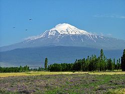
തുർക്കിയുടെ കിഴക്കേയറ്റത്തെ മഞ്ഞണിഞ്ഞതും നിർജ്ജീവവുമായ ഒരു അഗ്നിപർവ്വതമാണ് അരരാത്ത് പർവ്വതം.(/ˈærəræt/ ARR-ə-rat;[4] തുർക്കിഷ്: Ağrı Dağı; Armenian: Մասիս) ഇതിൽ രണ്ട് പ്രധാനപ്പെട്ട അഗ്നിപർവ്വത കോണുകളായ ഗ്രേറ്റർ അരരാത്ത്, ലിറ്റിൽ അരരാത്ത് എന്നിവയും കാണപ്പെടുന്നു. 5,137 മീറ്റർ (16,854 അടി) ഉയരമുള്ള തുർക്കിയിലെ ഏറ്റവും ഉയരമുള്ള കൊടുമുടിയും അർമേനിയൻ മലമ്പ്രദേശവുമാണ് ഗ്രേറ്റർ അരരാത്ത്. ലിറ്റിൽ അരരാത്തിന്റെ ഉയരം 3,896 മീറ്റർ (12,782 അടി) ആണ്.[5] അരരാത്ത് പർവ്വതനിരയ്ക്ക് ഗ്രൗണ്ട് അടിസ്ഥാനമാക്കി 35 കിലോമീറ്റർ (22 മൈൽ) വീതിയുണ്ട്.[6] അരരാത്തിന്റെ കൊടുമുടിയിലെത്താനുള്ള ആദ്യ ശ്രമങ്ങൾ മധ്യകാലഘട്ടത്തിലാണ് നടത്തിയത്. എന്നിരുന്നാലും, 1829-ൽ ഫ്രീഡ്രിക്ക് പാരറ്റും ഖചതൂർ അബോവിയനും മറ്റ് നാലുപേരും ചേർന്ന് നടത്തിയ ആദ്യത്തെ കയറ്റം രേഖപ്പെടുത്തി.
ഉല്പത്തി പുസ്തകത്തിലെ (8: 4) “അരരാത്ത് പർവ്വതനിരകൾ”, പർവ്വതാരോഹണത്തിൽ പ്രത്യേകം പരാമർശിക്കുന്നില്ലെന്ന് പണ്ഡിത സമവായം ഉണ്ടായിരുന്നിട്ടും അരരാത്ത് നോഹയുടെ പെട്ടകത്തിന്റെ വിശ്രമ കേന്ദ്രമായി ക്രിസ്തുമതത്തിൽ അംഗീകരിക്കപ്പെട്ടിട്ടുണ്ട്. അർമേനിയയുടെ പ്രധാന ദേശീയ പ്രതീകമായ ഈ പർവ്വതം അർമേനിയക്കാർ ഒരു പുണ്യപർവ്വതമായി കണക്കാക്കുന്നു. അർമേനിയൻ സാഹിത്യത്തിലും കലയിലും ഈ പർവ്വതം പ്രധാനമായും അവതരിപ്പിക്കപ്പെടുന്നു. അർമേനിയൻ ഇറെഡന്റിസത്തിന്റെ ഒരു പ്രതീകമായും ഈ പർവ്വതം കണക്കാക്കുന്നു. അർമേനിയയുടെ പതാകയിലും നോഹയുടെ പെട്ടകത്തിനൊപ്പം ഈ പർവ്വതം ചിത്രീകരിച്ചിരിക്കുന്നു.
രാഷ്ട്രീയ അതിർത്തികൾ
[തിരുത്തുക]തുർക്കി, അർമേനിയ, അസർബൈജാനിലെ നഖ്ചിവൻ എക്സ്ക്ലേവ്, ഇറാൻ എന്നിവയ്ക്കിടയിലുള്ള ഒരു ക്വാഡ്രിപോയിന്റ് ആണ് അരരാത്ത് പർവ്വതം. ഇറാനിയൻ അതിർത്തിയിൽ നിന്നും 16 കിലോമീറ്റർ (10 മൈൽ) പടിഞ്ഞാറ് ഭാഗത്തും അസർബൈജാനിലെ നഖിവൻ ഭൂപ്രദേശത്തിന്റെ അതിർത്തിയിലും അർമേനിയൻ അതിർത്തിയിൽ നിന്ന് 32 കിലോമീറ്റർ (20 മൈൽ) തെക്കായും അതിന്റെ കൊടുമുടി സ്ഥിതിചെയ്യുന്നു. ഏകദേശം 8 കിലോമീറ്റർ അകലെയുള്ള ടർക്കിഷ്-അർമേനിയൻ-അസർബൈജാനി, ടർക്കിഷ്-ഇറാനിയൻ-അസർബൈജാനി ട്രിപ്പോയിന്റുകൾ 39.6553 ° N 44.8034 at E അക്ഷാംശത്തിൽ നഖിവാനിലേക്ക് പ്രവേശിക്കുന്ന E99 റോഡ് ഉൾക്കൊള്ളുന്ന തുർക്കി പ്രദേശത്തിന്റെ ഒരു ഇടുങ്ങിയ ഭാഗം ഉപയോഗിച്ച് വേർതിരിച്ചിരിക്കുന്നു.
ഈ മേഖല പതിനാറാം നൂറ്റാണ്ട് മുതൽ 1828 വരെ ഓട്ടോമൻ-പേർഷ്യൻ അതിർത്തിയുടെ ഭാഗമായിരുന്നു. ഗ്രേറ്റ് അരരാത്തിന്റെ കൊടുമുടിയും വടക്കൻ ചരിവുകളും ലിറ്റിൽ അരരാത്തിന്റെ കിഴക്കൻ ചരിവുകളും പേർഷ്യ നിയന്ത്രിച്ചിരുന്നു. 1826–28 റുസ്സോ-പേർഷ്യൻ യുദ്ധത്തിനും തുർക്ക്മെൻചായ് ഉടമ്പടിക്കും ശേഷം പേർഷ്യൻ നിയന്ത്രണത്തിലുള്ള പ്രദേശം റഷ്യൻ സാമ്രാജ്യത്തിന് കീഴടങ്ങി. തുർക്കി, പേർഷ്യൻ, റഷ്യൻ സാമ്രാജ്യത്വ അതിർത്തികൾ ഒത്തുചേരുന്ന സ്ഥലമായി ലിറ്റിൽ അരരാത്ത് മാറി.[7] നിലവിലെ അന്താരാഷ്ട്ര അതിർത്തികൾ ഇരുപതാം നൂറ്റാണ്ടിലുടനീളം രൂപപ്പെട്ടതാണ്. 1920 ലെ തുർക്കി-അർമേനിയൻ യുദ്ധത്തിൽ പർവ്വതം തുർക്കിയുടെ നിയന്ത്രണത്തിലായി.[8] 1921 ലെ മോസ്കോ ഉടമ്പടിയും കാർസ് ഉടമ്പടിയും അനുസരിച്ച് ഈ പർവ്വതം തുർക്കിയുടെ ഭാഗമായി.[9] 1920 കളുടെ അവസാനത്തിൽ, തുർക്കി ഇറാനിയൻ അതിർത്തി കടന്ന് കുർദിഷ് അരരാത്ത് കലാപം അവസാനിപ്പിക്കാനുള്ള ശ്രമത്തിന്റെ ഭാഗമായി ലെസ്സർ അരരാത്തിന്റെ കിഴക്കൻ ഭാഗങ്ങൾ കൈവശപ്പെടുത്തി.[10] ഈ സമയത്ത് കുർദിഷ് വിമതർ ഈ പ്രദേശത്തെ തുർക്കി ഭരണകൂടത്തിനെതിരായ സുരക്ഷിത താവളമായി ഉപയോഗിച്ചു.[11] ഒരു പ്രദേശിക കൈമാറ്റത്തിലൂടെ ഈ പ്രദേശം തുർക്കിക്ക് കൈമാറാൻ ഇറാൻ സമ്മതിച്ചു.[10][12] ഇറാൻ-തുർക്കി അതിർത്തിയുടെ അറ്റം അരരാത്ത് പർവ്വതനിരകളുടെ താഴത്തെ കൊടുമുടിയായ ലെസ്സർ അരരാത്തിന് കിഴക്ക് കാണപ്പെടുന്നു.
2004 വരെ "സൈനിക അനുമതിയോടെ" മാത്രമേ മലകയറാൻ സാധിച്ചിരുന്നുള്ളൂ. പ്രത്യേക "അരരാത്ത് വിസ"യ്ക്കായി അനുമതി നേടുന്നതിനുള്ള നടപടിക്രമത്തിൽ ഒരു തുർക്കി എംബസിക്ക് ഔദ്യോഗിക അഭ്യർത്ഥന സമർപ്പിക്കുന്നതും ഇതിൽ ഉൾപ്പെടുന്നു. കൂടാതെ തുർക്കിഷ് ഫെഡറേഷൻ ഫോർ അൽപിനിസത്തിൽ നിന്ന് ഒരു ഔദ്യോഗിക ഗൈഡിനെ നിയമിക്കുന്നത് നിർബന്ധമാണ്. ആവശ്യമായ അനുമതി നേടുന്ന മലകയറ്റക്കാർക്ക് പോലും പ്രവേശനം ഇപ്പോഴും പരിമിതമാണ്. മാത്രമല്ല അംഗീകൃത പാതയിലൂടെ സഞ്ചരിക്കുന്നവരെ മുന്നറിയിപ്പില്ലാതെയും പുറത്താക്കാം.[13]
പേരുകളും പദോൽപ്പത്തിയും
[തിരുത്തുക].jpg)


ബിസി 9 മുതൽ 6 വരെ നൂറ്റാണ്ടുകളിൽ അർമേനിയൻ പീഠഭൂമിയിൽ നിലനിന്നിരുന്ന ഒരു രാജ്യം ആയ യുറാർട്ടു [14]എന്ന പേരിന്റെ എബ്രായ അക്ഷരവിന്യാസത്തിന്റെ (אֲרָרָט;[15] 'RRṬ) ഗ്രീക്ക് പതിപ്പാണ് അരരാത്ത് (ചിലപ്പോൾ അരറാദ്).[16] ജർമ്മൻ ഓറിയന്റലിസ്റ്റും ബൈബിൾ നിരൂപകനുമായ വിൽഹെം ഗെസെനിയസ് "അരരാത്ത്" എന്ന വാക്ക് "പുണ്യഭൂമി" എന്നർത്ഥം വരുന്ന അർജൻവർത്ത എന്ന സംസ്കൃത പദത്തിൽ നിന്നാണ് വന്നതെന്ന് അനുമാനിച്ചു.[17][18] അർമേനിയൻ ചരിത്രകാരന്മാരായ അശോത് മെൽകോണിയൻ, "അരരാത്ത്" എന്ന വാക്കിന്റെ ഉത്ഭവം അർമേനിയൻ ഉൾപ്പെടെയുള്ള അർമേനിയൻ മലമ്പ്രദേശത്തിലെ ("ar–") തദ്ദേശവാസികളുപയോഗിച്ചിരുന്ന പേരുകളുടെ വേരുകളുമായി ബന്ധിപ്പിക്കുന്നു.[19][20] യൂറോപ്യൻ ഭാഷകളിൽ ഈ പർവ്വതത്തെ അരരാത്ത് എന്നാണ് വിളിക്കുന്നത്[21][22]എന്നിരുന്നാലും, തദ്ദേശവാസികളാരും പരമ്പരാഗതമായി പർവ്വതത്തെ ആ പേരിൽ പരാമർശിച്ചിട്ടില്ല.[23]. പുരാതന പ്രാചീനതയിൽ, പ്രത്യേകിച്ച് സ്ട്രാബോയുടെ ജിയോഗ്രാഫിക്കയിൽ, അരരാത്തിന്റെ കൊടുമുടികൾ പുരാതന ഗ്രീക്കിൽ Ἄβος (അബോസ്), Νίβαρος (നിബറോസ്) എന്നറിയപ്പെട്ടിരുന്നു.[a]
പരമ്പരാഗത അർമേനിയൻ നാമം മാസിസ് (Մասիս [maˈsis]) എന്നാകുന്നു.[28][23] എന്നിരുന്നാലും, ഇപ്പോൾ, മാസിസ്, അരരാത്ത് എന്നീ പദങ്ങൾ രണ്ടും വ്യാപകമായി പരസ്പരം അർമേനിയൻ ഭാഷയിൽ ഉപയോഗിക്കുന്നു.[29] മോവ്സെസ് ഖൊറെനാറ്റ്സിയുടെ ഹിസ്റ്ററി ഓഫ് അർമേനിയയിൽ സൂചിപ്പിച്ചിരിക്കുന്ന നാടോടി പദോൽപ്പത്തിയിൽ അർമേനിയൻ ഗോത്രപിതാവ് ഹെയ്ക്കിന്റെ ചെറുമകനായ അമാസ്യ രാജാവിൽ നിന്നാണ് ഈ പേര് ലഭിച്ചത്. അദ്ദേഹത്തിന്റെ കാലശേഷം ഈ പർവതത്തെ മാസിസ് എന്ന പേര് വിളിച്ചതായി പറയപ്പെടുന്നു.[30][31] റഷ്യൻ ഓറിയന്റലിസ്റ്റ് അനറ്റോലി നോവോസെൽറ്റ്സെവിന്റെ അഭിപ്രായത്തിൽ മാസിസ് എന്ന പദം "ഏറ്റവും വലുത്" എന്നർത്ഥമുള്ള മധ്യകാല പേർഷ്യൻ പദമായ മാസിസ്റ്റിൽ നിന്ന് ഉരുത്തിരിഞ്ഞതാണ്."[32] അർമേനിയൻ ചരിത്രകാരനായ സർഗിസ് പെട്രോസ്യന്റെ അഭിപ്രായത്തിൽ മാസിസിന്റെ അർത്ഥം "പർവ്വതം" എന്നാണ്. cf. പ്രോട്ടോ-ഇന്തോ-യൂറോപ്യൻ * mņs-[31] പുരാവസ്തു ഗവേഷകനായ അർമെൻ പെട്രോഷ്യൻ പറയുന്നതനുസരിച്ച്, ഗിൽഗമെഷ് ഇതിഹാസത്തിൽ പരാമർശിച്ചിരിക്കുന്ന മാസു (മാഷു) പർവ്വതത്തിൽ നിന്നാണ് ഉത്ഭവിച്ചത്. ഇത് അസീറിയൻ ഭാഷയിൽ മസു എന്ന ധ്വനി നൽകുന്നു.[33]ഈ സിദ്ധാന്തമനുസരിച്ച്, ഈ പേര് "ഇരട്ട" എന്നാണ് അർത്ഥമാക്കുന്നത്. പർവതത്തിന്റെ ഇരട്ട കൊടുമുടികളെ ഇത് പരാമർശിക്കുന്നു. യുറാർട്ടിയൻ ഗ്രന്ഥങ്ങളിൽ പരാമർശിച്ചിരിക്കുന്നതും അരാറാത്ത് പർവതവുമായി തിരിച്ചറിയപ്പെടുന്നതുമായ ഒരു ദേശമായ എർകുവാഹി ഇതേ പേരിന്റെ തദ്ദേശീയ അർമേനിയൻ-ഭാഷാ രൂപത്തെ പ്രതിഫലിപ്പിക്കുന്നു. (അർമേനിയൻ എർകുവുമായി താരതമ്യം ചെയ്യുക (երկու, "രണ്ട്" എന്നർത്ഥം)[34]
ടർക്കിഷ് നാമം അഗ്രി ദാഗി [aːɾɯ da.ɯ], ഓട്ടോമൻ ടർക്കിഷ്: اغـر طﺎﻍ Ağr Dağ), അതായത് ""മൗണ്ടൻ ഓഫ് അഗ്രി"". അഗ്രി ശബ്ദാർത്ഥത്തിൽ "വേദന" അല്ലെങ്കിൽ "ദുഃഖം" എന്ന് വിവർത്തനം ചെയ്യുന്നു.[21][32][35][36] മധ്യകാലഘട്ടത്തിന്റെ അവസാനം മുതൽ ഈ പേര് അറിയപ്പെടുന്നു.[32] ഗ്രേറ്റർ, ലെസ്സർ അരരാത്ത് യഥാക്രമം ബുയുക്ക് അഗ്രി, കുക്ക് അഗ്രി എന്നിങ്ങനെ അറിയപ്പെടുന്നു. പേർഷ്യൻ പരമ്പരാഗത നാമം کوه نوح, [ˈkuːhe ˈnuːh], Kūh-e Nūḥ,[7] ശബ്ദാർത്ഥത്തിൽ "നോഹയുടെ പർവ്വതം ".[21][28] പർവ്വതത്തിന്റെ കുർദിഷ് പേര് çiyayê Agirî[37][38] [t͡ʃɪjaːˈje aːgɪˈriː], അത് "അഗ്നി പർവ്വതം" എന്ന് വിവർത്തനം ചെയ്യുന്നു.[39]
ഭൂമിശാസ്ത്രം
[തിരുത്തുക]തുർക്കിയുടെ കിഴക്കൻ അനറ്റോലിയ മേഖലയിൽ ഇറാൻ, അർമേനിയ, അസർബൈജാനിലെ നഖിവൻ അതിർത്തിക്കടുത്തുള്ള, അറസ്, മുറാത്ത് നദികൾക്കിടയിൽ അരരാത്ത് പർവ്വതം സ്ഥിതിചെയ്യുന്നു.[40] തുർക്കി-ഇറാൻ അതിർത്തിയിൽ നിന്ന് 16 കിലോമീറ്റർ (10 മൈൽ) പടിഞ്ഞാറും ടർകോ-അർമേനിയൻ അതിർത്തിയിൽ നിന്ന് 32 കിലോമീറ്റർ (20 മൈൽ) തെക്കുമാണ് ഇതിന്റെ കൊടുമുടി സ്ഥിതി ചെയ്യുന്നത്. അരരാത്ത് സമതലം അതിന്റെ വടക്കുപടിഞ്ഞാറ് ഭാഗത്തേക്ക് വ്യാപിച്ചു കിടക്കുന്നു.[41]
ഉയരം
[തിരുത്തുക]
പശ്ചിമേഷ്യയിലെ ഏറ്റവും പ്രധാനപ്പെട്ട മൂന്നാമത്തെ പർവ്വതമാണ് അരരാത്ത്. അരരാത്ത് പർവ്വതത്തിന് 5,165 മീറ്റർ (16,946 അടി) ഉയരമുള്ളതായി ചില വിശ്വവിജ്ഞാനകോശവും പരാമർശ ഗ്രന്ഥങ്ങളായ മെറിയം-വെബ്സ്റ്റേഴ്സ് ജിയോഗ്രാഫിക്കൽ ഡിക്ഷണറി, എൻസൈക്ലോപീഡിയ ഓഫ് വേൾഡ് ജ്യോഗ്രഫി എന്നിവ നൽകുന്നു.[42][43][44][45] എന്നിരുന്നാലും, യുണൈറ്റഡ് സ്റ്റേറ്റ്സ് ജിയോളജിക്കൽ സർവേയും ടോപ്പോഗ്രാഫിക് ഭൂപടങ്ങളും പോലുള്ള നിരവധി ഉറവിടങ്ങളും സൂചിപ്പിക്കുന്നത് 5,137 മീറ്റർ (16,854 അടി) എന്ന കണക്ക് വ്യാപകമായി കൂടുതൽ കൃത്യതയുള്ളതാണെന്നാണ്. [46][47] മൂടൽ മഞ്ഞു കൊണ്ടുള്ള മഞ്ഞുപാളികൾ ഉരുകിയതിനാൽ നിലവിലെ ഉയരം 5,125 മീറ്റർ (16,814 അടി) ആയിരിക്കാം.[48]
കൊടുമുടിയിലെ മഞ്ഞുപാളികൾ
[തിരുത്തുക]അരരാത്ത് പർവ്വത കൊടുമുടിയിലെ ഹിമപാത 1957 മുതൽ ചുരുങ്ങുകയാണ്. 1950 കളുടെ അവസാനത്തിൽ, 10 കി.m2 (3.9 ച മൈ) (3.9 ചതുരശ്ര മൈൽ) വിസ്തൃതിയുള്ള ഒരു കൊടുമുടിയുടെ മഞ്ഞിൽ നിന്ന് പുറത്തേക്കുള്ള 11 മാർഗ്ഗങ്ങളിലൂടെ ഹിമാനികൾ ഉയർന്നുവരുന്നതായി ബ്ലൂമെൻതൽ നിരീക്ഷിച്ചു.[49]അക്കാലത്ത്, അരരാത്ത് കൊടുമുടിയിലെ ഹിമാനികൾ വടക്ക് അഭിമുഖമായുള്ള ചരിവിൽ 3,900 മീറ്റർ (12,800 അടി) ഉയരത്തിലും തെക്ക് 4,200 മീറ്റർ (13,800 അടി) ഉയരത്തിലും ചരിവ് അഭിമുഖീകരിച്ചുകൊണ്ട് വ്യാപിക്കുന്നതായി കണ്ടെത്തി.[49]മുമ്പുണ്ടായിരുന്ന ഉപരിതല ചിത്രീകരണങ്ങളിലൂടെയും വിദൂരസംവേദന വസ്തുതകളും ഉപയോഗിച്ച്, സരകായയും മറ്റുള്ളവരും 1976 നും 2011 നും ഇടയിൽ അരരാത്ത് പർവ്വതത്തിലെ ഹിമപാതത്തിന്റെ വ്യാപ്തി പഠിക്കുകയുണ്ടായി.[37][50] ഈ മഞ്ഞുപാളികൾ 1976-ൽ 8.0 കിലോമീറ്റർ 2 (3.1 ചതുരശ്ര മൈൽ) ആയിരുന്നത് 2011 ആയപ്പോഴേക്കും 5.7 കിലോമീറ്റർ 2 (2.2 ചതുരശ്ര മൈൽ) ആയി ചുരുങ്ങിയതായി അവർ കണ്ടെത്തി. 1976 നും 2011 നും ഇടയിൽ അരരാത്ത് പർവ്വതത്തിന് മുകളിലുള്ള മഞ്ഞുപാളികൾ 29% നഷ്ടപ്പെട്ടുവെന്ന് അവർ കണക്കാക്കി. 35 വർഷത്തിനിടയിൽ ഐസ് നഷ്ടപ്പെടുന്നതിന്റെ മൊത്തം വിസ്തീർണ്ണം പ്രതിവർഷം ശരാശരി 0.07 കിലോമീറ്റർ 2 (0.027 ചതുരശ്ര മൈൽ) ആണെന്നും കണ്ടെത്തി. ഈ നിരക്ക് മറ്റ് ടർക്കിഷ് കൊടുമുടിയിലെ ഹിമാനികളുടെയും മഞ്ഞുപാളികളുടെയും പൊതുവായ നിരക്കുകളുമായി പൊരുത്തപ്പെടുന്നതായി മറ്റ് പഠനങ്ങൾ രേഖപ്പെടുത്തിയിട്ടുണ്ട്.[50]
അവസാന പ്ലീസ്റ്റോസീൻ കാലഘട്ടത്തിൽ ഹിമപ്രാന്തം 3,000 മീറ്റർ (9,800 അടി) ഉയരത്തിലായിരുന്നുവെന്ന് ബ്ലൂമെൻതൽ കണക്കാക്കി.[49] അത്തരമൊരു ഹിമപ്രാന്തം100 കി.m2 (39 ച മൈ) (39 ചതുരശ്ര മൈൽ) വിസ്തീർണ്ണമുള്ള മഞ്ഞുപാളികൾ സൃഷ്ടിക്കുമായിരുന്നു. എന്നിരുന്നാലും, 1958-ലെ ഹിമാനികളുടെ നാവുകൾക്ക് സമീപമുള്ള ചരിത്രാതീത മൊറൈനുകളുടെ വ്യക്തമായ തെളിവുകളുടെ അഭാവം അദ്ദേഹം നിരീക്ഷിച്ചു. ഹിമാനികളെ നിയന്ത്രിക്കാനുള്ള വരമ്പുകളുടെ അഭാവവും മഞ്ഞുപാളികൾ രൂപപ്പെടാൻ ആവശ്യമായ അവശിഷ്ടങ്ങൾ ഹിമപാളികളിൽ ലോഡ് ചെയ്യപ്പെടാത്തതും പിന്നീടുള്ള സ്ഫോടനങ്ങളാൽ അവയെ സംസ്കരിക്കുന്നതും ബ്ലൂമെന്റൽ വിശദീകരിച്ചു. വർഷങ്ങൾക്കുശേഷം, തെക്ക് അഭിമുഖമായുള്ള ചരിവുകളിൽ 1958-ലെ ഹിമപാതത്തിന്റെ അടിത്തട്ടിൽ നിന്ന് 4,200 മീറ്റർ (13,800 അടി) ഉയരത്തിലും കുറഞ്ഞത് 300 മീറ്റർ (980 അടി) ഉയരത്തിലും വ്യാപിക്കാൻ സാധ്യതയുള്ള മൊറെയ്ൻ ബിർമാൻ നിരീക്ഷിച്ചു.[51]പ്ലീസ്റ്റോസീനിലെ മൗണ്ട് അരരാത്ത് താഴ്വരയിലും വിസ്കോൺസിനാൻ യുഗത്തിലെ (അവസാനത്തെ പരമാവധി ഹിമാനികൾ), ബാലക് തടാകത്തിൽ നിന്നുള്ള താഴ്വരയിലും ഹിമാനികൾ സൃഷ്ടിച്ച രണ്ട് മൊറൈനൽ നിക്ഷേപങ്ങളും അദ്ദേഹം കണ്ടെത്തിയിരുന്നു. ഇത് ഉയർന്ന മൊറെയ്ൻ 2,200 മീറ്റർ (7,200 അടി) ഉയരത്തിലും താഴത്തെ മൊറെയ്ൻ 1,800 മീറ്റർ (5,900 അടി) ഉയരത്തിലും സ്ഥിതിചെയ്യുന്നു. ബാലെക് തടാകത്തിൽ നിന്ന് 15 കിലോമീറ്റർ (9.3 മൈൽ) താഴെയാണ് മൊറെയ്ൻ സംഭവിച്ചിരുന്നത്. രണ്ട് മൊറെയ്നുകളും ഏകദേശം 30 മീറ്റർ (98 അടി) ഉയരത്തിലാണ്. ബലൂക് തടാകം ഒരു ഹിമാനിതടമായും സംശയിക്കുന്നു.[51]
ജിയോളജി
[തിരുത്തുക]പോളിജെനിക്, സംയുക്ത സ്ട്രാറ്റോവോൾക്കാനോയാണ് അരരാത്ത് പർവ്വതം. 1,100 കിലോമീറ്റർ 2 (420 ചതുരശ്ര മൈൽ) വിസ്തൃതിയുള്ള ഈ പ്രദേശത്തെ ഏറ്റവും വലിയ അഗ്നിപർവ്വത ഭാഗമാണിത്. വടക്കുപടിഞ്ഞാറൻ-തെക്കുകിഴക്കൻ ഗതിയിലെ നീളമുള്ള അക്ഷത്തിൽ, അരരാത്ത് പർവ്വതം 45 കിലോമീറ്റർ (28 മൈൽ) നീളവും ഹ്രസ്വ അക്ഷത്തിൽ 30 കിലോമീറ്റർ (19 മൈൽ) നീളവും കാണപ്പെടുന്നു. 1,150 കിലോമീറ്റർ 3 (280 ക്യു മൈൽ) ഡാസിറ്റിക്, റിയോലിറ്റിക് പൈറോക്ലാസ്റ്റിക് അവശിഷ്ടങ്ങളും ഡാസിറ്റിക്, റിയോലിറ്റിക്, ബസാൾട്ടിക് ലാവകളും ഇതിൽ അടങ്ങിയിരിക്കുന്നു.[5]
ഗ്രേറ്റർ അരരാത്ത്, ലെസ്സർ അരരാത്ത് (ലിറ്റിൽ അരരാത്ത്) എന്നിങ്ങനെ രണ്ട് വ്യത്യസ്ത അഗ്നിപർവ്വത കോണുകൾ അടങ്ങിയതാണ് അരരാത്ത് പർവ്വതം. പടിഞ്ഞാറൻ അഗ്നിപർവ്വത കോൺ ആയ ഗ്രേറ്റർ അരരാത്ത്, കുത്തനെയുള്ള വശങ്ങളുള്ള അഗ്നിപർവ്വത കോണാണ്. അത് കിഴക്കൻ അഗ്നിപർവ്വത കോണിനേക്കാൾ വലുതും ഉയർന്നതുമാണ്. ഗ്രേറ്റർ അരരാത്തിന്റെ അടിത്തട്ടിൽ 25 കിലോമീറ്റർ (16 മൈൽ) വീതിയും 3 കിലോമീറ്റർ (1.9 മൈൽ) ഉയരത്തിൽ ഇഡ്ഗിർ, ഡോസുബയാസാറ്റ് നദീതടങ്ങളുടെ തൊട്ടടുത്ത തട്ടുകളിൽ നിന്നും ഉയരുന്നു. കിഴക്കൻ അഗ്നിപർവ്വത കോൺ, ലെസ്സർ അരരാത്ത് 3,896 മീറ്റർ (12,782 അടി) ഉയരവും 15 കിലോമീറ്റർ (9.3 മൈൽ) കുറുകെയും കാണപ്പെടുന്നു.13 കിലോമീറ്റർ (8.1 മൈൽ) അകലെയുള്ള ഈ അഗ്നിപർവ്വത കോണുകൾ വിശാലമായ വടക്ക്-തെക്ക്-തിരിയുന്ന വിള്ളലുകളാൽ വേർതിരിക്കപ്പെടുന്നു. വിപുലീകരണ ഫൗൾട്ടിന്റെ ഉപരിതലത്തിലാണ് ഈ വിള്ളൽ. ഈ ഫൗൾട്ടിന്റെ പ്രധാന അഗ്നിപർവ്വത കോണുകളുടെ അരികുകളിലും നിരവധി പാരസിറ്റിക് കോണുകളും ലാവ ഡംമുകളും കൊണ്ട് നിർമ്മിച്ചിരിക്കുന്നു.[5]
അനേക ഭാഗങ്ങളുള്ള തൂക്കായ -ഭാഗിക തടങ്ങളുടെ ഇടംപിരിയായാണ് അരരാത്ത് പർവ്വതം സ്ഥിതിചെയ്യുന്നത്. ആരംഭത്തിൽ അത് ഇടമുറിയാതെയുള്ള ഒറ്റ നിമ്നഭാഗം ആയിരുന്നു. അരാരത്ത് പർവ്വതത്തിന്റെ വളർച്ച ഈ നിമ്നഭാഗത്തെ ഇഡ്ഗിർ, ഡോബുബയാസത്ത് നദീതടങ്ങൾ എന്നീ രണ്ട് ചെറിയ തടങ്ങളായി വിഭജിച്ചു. അനേക ഭാഗങ്ങളുള്ള സ്ട്രൈക്ക്-സ്ലിപ്പ് ഫോൾട്ട് സിസ്റ്റത്തിന്റെ രണ്ട് എൻ-എക്കലോൺ ഫോൾട്ട് സെഗ്മെന്റുകളായ ഡൊബൂബയാസാറ്റ്-ഗർബുലക്, ഇഡ്ഗിർ ഫാൾട്ടുകൾ എന്നിവയ്ക്കൊപ്പം സ്ട്രൈക്ക്-സ്ലിപ്പ് ഫൗൾട്ടിന്റെ ഫലമാണ് ഈ തൂക്കായ-ഭാഗിക തടങ്ങൾ. ഈ ഫാൾട്ടുകൾ തമ്മിലുള്ള വലിവ് തുടക്കത്തിൽ തൂക്കായ-ഭാഗിക തടങ്ങൾ രൂപപ്പെടുത്തുക മാത്രമല്ല, ഒരു ഹോഴ്സ്റ്റെയിൽ സ്പ്ലേ പാറ്റേൺ പ്രദർശിപ്പിക്കുകയും, ഇത് അരാരത്ത് പർവ്വതത്തിലെ പ്രധാന അഗ്നിപർവ്വത സ്ഫോടന കേന്ദ്രങ്ങളുടെയും പാരസിറ്റിക് അഗ്നിപർവ്വത കോണുകളുടെ അനുബന്ധ ലീനിയർ ബെൽറ്റിന്റെയും സ്ഥാനം നിയന്ത്രിക്കുകയും ചെയ്യുന്നു. വടക്ക്-തെക്ക് കൂടിച്ചേരലിന്റെ ഫലമായി അരരാത്ത് പർവ്വതം സ്ഥിതിചെയ്യുന്ന സ്ട്രൈക്ക്-സ്ലിപ്പ് ഫൗൾട്ട് സംവിധാനം അറേബ്യയിലെ ഉയർന്ന സ്ഥലങ്ങളും ലോറേഷ്യയും തമ്മിലുള്ള ടെക്റ്റോണിക് കംപ്രഷൻ, ഫലമായി ഈയോസീൻ കാലഘട്ടത്തിൽ ടെത്തിസ് മഹാസമുദ്രം ബിറ്റ്ലിസ്-സാഗ്രോസ് സൂച്ചറിനോടൊപ്പം തുടർന്ന് അടയുകയും ചെയ്തു.[5][52][53]
ഭൂമിശാസ്ത്ര ചരിത്രം
[തിരുത്തുക]

ആദ്യകാല ഈയോസിനിന്റെയും മയോസീന്റെയും കാലഘട്ടത്തിൽ, ലോറേഷ്യയുമായുള്ള അറേബ്യൻ ഫലകങ്ങളുടെ കൂട്ടിയിടി ഇപ്പോഴത്തെ അനറ്റോലിയയുടെ പ്രദേശത്ത് നിന്ന് ടെത്തിസ് സമുദ്രം മാറ്റപ്പെട്ടു. മധ്യ ഇയോസീൻ കാലഘട്ടത്തിൽ കോണ്ടിനെന്റൽ ക്രസ്റ്റിന്റെ ഈ മുഖ്യഭാഗം അടഞ്ഞതോടെ ഈ സമുദ്രതടം ഇല്ലാതെയായി. കൂട്ടിയിടിക്ക് ശേഷമുള്ള ടെക്റ്റോണിക് ഒത്തുചേരലിന്റെ ഫലമായി കിഴക്കൻ അനറ്റോലിയയിൽ നിന്ന് ആദ്യകാല മയോസീനിന്റെ അവസാനത്തിൽ അവശേഷിക്കുന്ന സമുദ്രങ്ങൾ പൂർണ്ണമായും ഇല്ലാതാകുകയും കൂട്ടിയിടി മേഖലയിലുടനീളം ക്രസ്റ്റൽ ചെറുതാക്കുകയും ഉറപ്പിക്കുകയും കിഴക്കൻ അനറ്റോലിയൻ-ഇറാനിയൻ പീഠഭൂമി ഉയരുന്നതിനും ഇത് കാരണമായി. ഈ ഉയർച്ചയ്ക്കൊപ്പം മടക്കിക്കളയുന്നതും വഴി വിപുലമായ രൂപഭേദം സംഭവിക്കുകയും ഇത് നിരവധി പ്രാദേശിക തടങ്ങൾ സൃഷ്ടിക്കുന്നതിനും കാരണമായി. ഫൗൾട്ടിംഗ്, അഗ്നിപർവ്വതം, ഭൂകമ്പം എന്നിവയ്ക്ക് തെളിവായി വടക്ക്-തെക്ക് ചുരുങ്ങുന്നതിലൂടെ രൂപഭേദം ഇന്നും തുടരുന്നു.[5][52][54]
അനറ്റോലിയയ്ക്കുള്ളിൽ, പ്രാദേശിക അഗ്നിപർവ്വതം ഉടലെടുത്തത് മയോസെൻ കാലഘട്ടത്തിന്റെ മധ്യത്തിലാണ്. മയോസീൻ-പ്ലിയോസീൻ കാലഘട്ടത്തിന്റെ അവസാനത്തിൽ, വ്യാപകമായ അഗ്നിപർവ്വതം മുഴുവൻ കിഴക്കൻ അനറ്റോലിയൻ-ഇറാനിയൻ പീഠഭൂമിയെ കട്ടിയുള്ള അഗ്നിപർവ്വത പാറകൾക്കടിയിൽ പുതപ്പിച്ചു. ഈ അഗ്നിപർവ്വത പ്രവർത്തനം ചരിത്രകാലം വരെ തടസ്സമില്ലാതെ തുടരുന്നു. 6 മുതൽ 3 മാ വരെ ഏറ്റവും പുതിയ മയോസെൻ-പ്ലിയോസീൻ കാലഘട്ടത്ത് ഇതൊരു പാരമ്യത്തിലെത്തി. ക്വട്ടേണറി കാലഘട്ടത്തിൽ അഗ്നിപർവ്വതം അരരാത്ത് പർവ്വതം പോലുള്ള ചില പ്രാദേശിക അഗ്നിപർവ്വതങ്ങളിൽ മാത്രമായി പരിമിതപ്പെട്ടു. ഈ അഗ്നിപർവ്വതങ്ങൾ അനറ്റോലിയയുടെ തുടർച്ചയായി വടക്ക്-തെക്ക് ക്ഷയിക്കുന്നതു മൂലം രൂപം കൊള്ളുന്ന വലിവ് വിള്ളലുകളുമായി ബന്ധപ്പെട്ടിരിക്കുന്നു.[5]
അനറ്റോലിയയിലെ ക്വട്ടേണറി കാലഘട്ടത്തിലെ അഗ്നിപർവ്വതത്തെക്കുറിച്ചുള്ള യിൽമാസും മറ്റുള്ളവരുടെയും വിശദമായ പഠനത്തിലും സംഗ്രഹത്തിലും, ഹിമാനി താഴ്വരകളിൽ തുറന്നുകാണിക്കുന്ന അഗ്നിപർവ്വത പാറകളിൽ നിന്ന് അരരാത്ത് പർവ്വതത്തിന്റെ നിർമ്മാണത്തിന്റെ നാല് ഘട്ടങ്ങൾ തിരിച്ചറിഞ്ഞു.[5]ആദ്യം, പ്ലീനിയൻ-സബ്പ്ലീനിയൻ വിള്ളൽ പൊട്ടിത്തെറിയുടെ ഘട്ടം 700 മീറ്ററിൽ (2,300 അടി) പൈറോക്ലാസ്റ്റിക് പാറകളും കുറച്ച് ബസാൾട്ടിക് ലാവാ പ്രവാഹങ്ങളും നിക്ഷേപിക്കുന്നതായി അവർ തിരിച്ചറിഞ്ഞു. ഈ അഗ്നിപർവ്വത പാറകൾ ഏകദേശം വടക്കുപടിഞ്ഞാറൻ-തെക്ക്, തെക്ക് കിഴക്ക്-ലക്ഷ്യമാക്കുന്ന വിപുലീകരണ ഫൗൾട്ടിൽ നിന്നും അരരാത്ത് പർവ്വതത്തിന്റെ വികാസത്തിന് മുമ്പ് പൊട്ടിത്തെറിച്ചു. രണ്ടാമതായി, ഒരു വിള്ളലിനൊപ്പം ഒരു ഘട്ടത്തിൽ അഗ്നിപർവ്വത പ്രവർത്തനങ്ങൾ പ്രാദേശികവൽക്കരിക്കപ്പെട്ടപ്പോൾ ഒരു കോൺ-നിർമ്മാണ ഘട്ടം ആരംഭിച്ചു. ഈ ഘട്ടത്തിൽ, 150 മീറ്റർ (490 അടി) വരെ കട്ടിയുള്ള ലാവയുടെ ഒഴുക്ക്, ആൻസൈറ്റ്, ഡാസൈറ്റ് കോമ്പോസിഷന്റെ പൈറോക്ലാസ്റ്റിക് പ്രവാഹങ്ങളും പിന്നീട് ബസാൾട്ടിക് ലാവാ പ്രവാഹങ്ങളും പൊട്ടിത്തെറിച്ച് ഗ്രേറ്റർ അരരാത്ത് കോൺ രൂപപ്പെട്ടു. മൂന്നാമത്, ഒരു കാലാവസ്ഥാ ഘട്ടത്തിൽ, ആൻഡെസിറ്റിക്, ബസാൾട്ടിക് ലാവകളുടെ ധാരാളം ഒഴുക്ക് പൊട്ടിപ്പുറപ്പെട്ടു. ഈ ഘട്ടത്തിൽ, ഗ്രേറ്റർ, ലെസ്സർ അരരാത്ത് എന്നിവയുടെ നിലവിലെ കോണുകൾ രൂപവത്കരിച്ചത് അനുബന്ധ വിള്ളലുകളിലും അരികുകളിലുമാണ്. അവസാനമായി, അരരാത്ത് പർവ്വതത്തിലെ അഗ്നിപർവ്വത സ്ഫോടനങ്ങൾ ഒരു ചെറിയ പൊട്ടിത്തെറി ഘട്ടമായി മാറി. ഈ സമയത്ത് വടക്ക്-തെക്ക്-ലക്ഷ്യമാക്കുന്ന ഒരു പ്രധാന ഫൗൾട്ടിനൊപ്പം രണ്ട് കോണുകളും ഒപ്പം വികസിച്ച നിരവധി കോണുകളും അഗ്നിപർവ്വതത്തിന്റെ അരികുകളിലെ വിള്ളലുകളും ഒന്നിച്ചാക്കി. ഈ തകരാറിനൊപ്പം അനുബന്ധ വിള്ളലുകളും ചെറിയ പൊട്ടിത്തെറികളാൽ നിരവധി പാരസിറ്റിക് കോണുകളും ഡംമുകളും നിർമ്മിക്കപ്പെട്ടു. ഒരു സബ്സിഡിയറി കോൺ പൊട്ടിത്തെറിച്ചു വലിയ ബസാൾട്ടും ആൻഡെസൈറ്റ് ലാവാ പ്രവാഹങ്ങളും ഉണ്ടായി. അവ ഡോബുബയാസത്ത് സമതലത്തിലൂടെ തെക്ക് സരിസു നദിയിലൂടെ ഒഴുകുന്നു. കറുത്ത ʻaʻā യും പഹോഹോ ലാവായും ചേർന്ന് ലാവാ പ്രവാഹമുണ്ടാകുകയും അതിൽ നന്നായി സംരക്ഷിക്കപ്പെട്ട ലാവ ട്യൂബുകളും അടങ്ങിയിരിക്കുന്നു. [5]ഈ ലാവാ പ്രവാഹങ്ങളുടെ റേഡിയോമെട്രിക് ഡേറ്റിംഗിൽ 0.4, 0.48, 0.81 Ma എന്നീ റേഡിയോമെട്രിക് പ്രായം കണ്ടെത്തി.[55] മൊത്തത്തിൽ, അരരാത്ത് പർവ്വതം പൊട്ടിത്തെറിച്ച അഗ്നിപർവ്വത പാറകളിൽ നിന്ന് ലഭിച്ച റേഡിയോമെട്രിക് പ്രായം 1.5 മുതൽ 0.02 Ma ആയിരുന്നു.[5]
സമീപകാല അഗ്നിപർവ്വത, ഭൂകമ്പ പ്രവർത്തനം
[തിരുത്തുക]അരരാത്ത് പർവ്വതവുമായി ബന്ധപ്പെട്ട ഹോളോസീൻ അഗ്നിപർവ്വത പ്രവർത്തനങ്ങളുടെ കാലഗണന പുരാവസ്തു ഗവേഷണങ്ങൾ, വാക്കാലുള്ള ചരിത്രം, ചരിത്രരേഖകൾ അല്ലെങ്കിൽ ഈ ഡാറ്റയുടെ സംയോജനം എന്നിവയിലൂടെ രേഖപ്പെടുത്തപ്പെട്ടിരിക്കുന്നു. ഇത് അരരാത്ത് പർവ്വതത്തിൽ അഗ്നിപർവ്വത സ്ഫോടനങ്ങൾ നടന്നതായി തെളിവുകൾ നൽകുന്നു. ബിസി 2500–2400 ബിസി 550, ഒരുപക്ഷേ എ.ഡി 1450 ലും എ ഡി 1783 ലും എ ഡി 1840 ലും നടന്നതായി കണക്കാക്കുന്നു. അരരാത്ത് പർവ്വതത്തിന്റെ വടക്കുപടിഞ്ഞാറൻ ഭാഗത്ത് നിന്ന് സ്ഫോടനാത്മകമായ പൊട്ടിത്തെറികളും പൈറോക്ലാസ്റ്റിക് പ്രവാഹങ്ങളും ഉണ്ടായതായും അതിൽ കുര-അറാക്സ് സംസ്കാര വാസസ്ഥലമെല്ലാം നശിക്കുകയും മൂടുകയും ബിസി 2500–2400-ൽ നിരവധി മരണങ്ങൾക്ക് കാരണമാവുകയും ചെയ്തതായി പുരാവസ്തു തെളിവുകൾ വ്യക്തമാക്കുന്നു. ബിസി 550-ൽ നിശ്ചയമില്ലാത്ത ഗണ്യമായ പൊട്ടിത്തെറി ഉണ്ടായതായും എ ഡി 1450 ലും എ ഡി 1783 ലും ചെറിയ പൊട്ടിത്തെറികൾ ഉണ്ടായേക്കാമെന്ന് വാമൊഴി ചരിത്രങ്ങൾ സൂചിപ്പിക്കുന്നു. [56][53][54][57] ചരിത്രപരവും പുരാവസ്തുപരവുമായ വിവരങ്ങളുടെ വ്യാഖ്യാനമനുസരിച്ച്, അഗ്നിപർവ്വത സ്ഫോടനങ്ങളുമായി ബന്ധമില്ലാത്ത ശക്തമായ ഭൂകമ്പങ്ങളും എ.ഡി 139, 368, 851–893, എ.ഡി 1319 എന്നിവയിൽ അരരാത്ത് പർവതത്തിന്റെ പ്രദേശത്തും സംഭവിച്ചു.[53][54][58]
1840-ലെ പൊട്ടിത്തെറി
[തിരുത്തുക]1840 ജൂലൈ 2 ന് അരരാത്ത് പർവ്വതത്തിൽ ഒരു ഫ്രീറ്റിക് പൊട്ടിത്തെറിയുണ്ടാകുകയും പർവ്വതത്തിന്റെ മുകൾ ഭാഗത്തെ റേഡിയൽ വിള്ളലുകളിൽ നിന്നുള്ള പൈറോക്ലാസ്റ്റിക് പ്രവാഹവും 7.4 തീവ്രത രേഖപ്പെടുത്തിയ ഭൂകമ്പവും കനത്ത നിരവധി നാശനഷ്ടങ്ങൾക്കും കാരണമായി. ഭൂകമ്പത്തിൽ ഈ പ്രദേശത്തെ പതിനായിരത്തോളം പേർ മരിച്ചു. ഇതിൽ 1,900 ഗ്രാമവാസികളടക്കം അഖുരി ഗ്രാമത്തിൽ (അർമേനിയൻ: അകോറി, ആധുനിക യെനിഡോസാൻ) ഭീമാകാരമായ മണ്ണിടിച്ചിലും തുടർന്നുള്ള അവശിഷ്ടങ്ങളുടെ ഒഴുക്കും മൂലം കൊല്ലപ്പെട്ടു. കൂടാതെ, മണ്ണിടിച്ചിലും അവശിഷ്ടങ്ങളുടെ ഒഴുക്കും കൂടിച്ചേർന്ന് അകോറിക്ക് സമീപമുള്ള സെന്റ് ജേക്കബിന്റെ അർമേനിയൻ മഠം, അരാലിക് പട്ടണം, നിരവധി ഗ്രാമങ്ങൾ, റഷ്യൻ സൈനിക ബാരക്കുകൾ എന്നിവ നശിച്ചു. ഇത് സെവ്ജുർ (മെറ്റ്സാമോർ) നദിയെ താൽക്കാലികമായി നശിപ്പിച്ചു.[56][53][54][57]
കയറ്റം
[തിരുത്തുക]പതിമൂന്നാം നൂറ്റാണ്ടിലെ റുബ്രൂക്കിലെ വില്യം ഇങ്ങനെ എഴുതി: "പലരും അതിൽ കയറാൻ ശ്രമിച്ചു, പക്ഷേ ആർക്കും കഴിഞ്ഞില്ല."[59]
അർമേനിയൻ നിലപാട്
[തിരുത്തുക]ചരിത്രപരമായി മതപരമായ കാരണങ്ങളാൽ അർമേനിയൻ അപ്പോസ്തോലിക സഭ അരരാത്ത് പർവ്വതകയറ്റത്തെ എതിർത്തു. പതിനെട്ടാം നൂറ്റാണ്ടിലെ ഇംഗ്ലീഷ് ദൈവശാസ്ത്രജ്ഞനായ തോമസ് സ്റ്റാക്ക്ഹൗസ് ഇങ്ങനെ കുറിച്ചു: “അരരാത്ത് പർവ്വതത്തിന്റെ കൊടുമുടിയിൽ നോഹയുടെ പെട്ടകം ഇന്നുവരെ നിലനിൽക്കുന്നുണ്ടെന്ന് എല്ലാ അർമേനിയക്കാരും ഉറച്ചു വിശ്വസിക്കുന്നു. അത് സംരക്ഷിക്കുന്നതിനായി ഒരു വ്യക്തിയ്ക്കും അരരാത്ത് കൊടുമുടിയിൽ കയറാൻ അനുവാദമില്ല.[60] "പാരറ്റിന്റെയും അബോവിയന്റെയും ആദ്യത്തെ കയറ്റത്തിന് മറുപടിയായി, അർമേനിയൻ അപ്പസ്തോലിക സഭയിലെ ഒരു പുരോഹിതൻ വിശുദ്ധ പർവ്വതത്തിൽ കയറുകയെന്നത് "എല്ലാ മനുഷ്യരുടെയും അമ്മയുടെ ഗർഭപാത്രത്തെ ഒരു മഹാസർപ്പം കൊണ്ട് കെട്ടുന്നതിന് സമമാണെന്ന്" അഭിപ്രായപ്പെട്ടു. ഇതിനു വിപരീതമായി, ഇരുപത്തിയൊന്നാം നൂറ്റാണ്ടിൽ അരാരത്ത് കയറുകയെന്നത് "അർമേനിയൻ പ്രവാസികളിൽ നിന്നും വർദ്ധിച്ചുവരുന്ന സംഘടിത ദേശസ്നേഹ തീർത്ഥാടനങ്ങളിൽ ഏറ്റവും മൂല്യവത്തായ ലക്ഷ്യമാണ്.[61]
ആദ്യത്തെ കയറ്റം
[തിരുത്തുക]

ആധുനിക കാലത്ത് രേഖപ്പെടുത്തിയ ആദ്യത്തെ മലകയറ്റം 1829 ഒക്ടോബർ 9 നാണ് നടന്നത് [O.S. 27 സെപ്റ്റംബർ] 9 October [O.S. 27 September] 1829.[62][63][64][65] റഷ്യയുടെ കാപ്ച്യൂർ ഓഫ് എറിവാനു ഏകദേശം രണ്ട് വർഷത്തിന് ശേഷം, അരറാത്ത് പര്യവേക്ഷണം ചെയ്യാനുള്ള ഏക ഉദ്ദേശ്യത്തിനായി ഡോർപാറ്റ് സർവകലാശാലയിലെ ബാൾട്ടിക് ജർമ്മൻ പ്രകൃതിശാസ്ത്രജ്ഞൻ ഫ്രീഡ്രിക്ക് പാരറ്റ് 1829 സെപ്റ്റംബർ പകുതിയോടെ എച്ച്മിയാഡ്സിനിൽ എത്തി.[66] പ്രമുഖ അർമേനിയൻ എഴുത്തുകാരൻ ഖചതൂർ അബോവിയൻ, അന്ന് എച്ച്മിയാഡ്സിനിലെ ഡീക്കനും വിവർത്തകനുമായിരുന്നു. അർമേനിയൻ സഭയുടെ തലവനായ കത്തോലിക്കോസ് യെപ്രെം, വ്യാഖ്യാതാവും വഴികാട്ടിയും ആയി നിയമിക്കപ്പെട്ടു.
പാരറ്റ്, അബോവിയൻ എന്നിവർ അരാസ് നദി കടന്ന് സുർമാലി ജില്ലയിലേക്ക് കടന്ന് സമുദ്രനിരപ്പിൽ നിന്ന് 1,220 മീറ്റർ (4,000 അടി) ഉയരത്തിൽ അരാരത്തിന്റെ വടക്കൻ ചരിവിലുള്ള അർമേനിയൻ ഗ്രാമമായ അഖുരിയിലേക്ക് പോയി. സെൻറ് ഹാക്കോബിലെ അർമേനിയൻ മഠത്തിലും 730 മീറ്റർ (2,400 അടി) ഉയരത്തിലും 1,943 മീറ്റർ (6,375 അടി) ഉയരത്തിലും അവർ ഒരു ബേസ് ക്യാമ്പ് സ്ഥാപിച്ചു. പരാജയപ്പെട്ട രണ്ട് ശ്രമങ്ങൾക്ക് ശേഷം, 1829 ഒക്ടോബർ 9 ന് അവരുടെ മൂന്നാമത്തെ ശ്രമത്തിൽ ഉച്ചകഴിഞ്ഞ് 3:15 ന് അവർ കൊടുമുടിയിലെത്തി. സംഘത്തിൽ പാരറ്റ്, അബോവിയൻ, രണ്ട് റഷ്യൻ സൈനികർ - അലക്സി സോഡൊറോവെങ്കോ, മാറ്റ്വെയ് ചൽപനോവ് - അർമേനിയൻ അഖുരി ഗ്രാമവാസികളായ ഹോഹന്നാസ് ഐവാസിയൻ, മുറാദ് പോഗോസിയൻ എന്നിവരുമുൾപ്പെട്ടിരുന്നു.[67] മെർക്കുറി ബാരോമീറ്റർ ഉപയോഗിച്ച് പാരറ്റ് 5,250 മീറ്റർ (17,220 അടി) ഉയരം അളന്നു. അരരാത്തിലേയ്ക്കുള്ള ആദ്യത്തെ കയറ്റം മാത്രമല്ല, ചിലിയൻ ആൻഡീസിലെ ലികാൻകബൂർ പർവ്വതത്തിന് പുറത്ത് മനുഷ്യൻ കയറിയ രണ്ടാമത്തെ ഉയർന്ന ഉയരവും കൂടിയായിരുന്നു ഇത്. അബോവിയൻ മഞ്ഞിൽ കുഴിച്ച് വടക്ക് അഭിമുഖമായി ഒരു മരക്കുരിശ് സ്ഥാപിച്ചു.[68] അബോവിയൻ കൊടുമുടിയിൽ നിന്ന് ഒരു ഐസ് കഷണം എടുത്ത് വെള്ളം വിശുദ്ധമായി കരുതി ഒരു കുപ്പിയിൽ കൂടെ കൊണ്ടുപോയി. നവംബർ 8 ന് [O.S. ഒക്ടോബർ 27] 1829, പാരറ്റ്, അബോവിയൻ എന്നിവർ വഴികാട്ടിയായി അഖുരി വേട്ടക്കാരനായ സഹാക്കിന്റെ സഹോദരൻ ഹാക്കോയും ചേർന്ന് ലെസ്സർ അരരാത്തിൽ കയറി.[69]
പിന്നീട് ശ്രദ്ധേയമായ പർവ്വത ആരോഹണങ്ങൾ
[തിരുത്തുക]റഷ്യൻ കാലാവസ്ഥാ ശാസ്ത്രജ്ഞനും കാലാവസ്ഥാ നിരീക്ഷകനുമായ കോസ്മ സ്പാസ്കി-അവ്റ്റനോമോവ് (ഓഗസ്റ്റ് 1834), കാൾ ബെഹെറൻസ് (1835), ജർമ്മൻ ധാതുശാസ്ത്രജ്ഞനും ജിയോളജിസ്റ്റുമായ ഓട്ടോ വിൽഹെം ഹെർമൻ വോൺ അബിച് (29 ജൂലൈ 1845), [70] ബ്രിട്ടീഷ് രാഷ്ട്രീയക്കാരനായ ഹെൻറി ഡാൻബി സീമോർ (1848) [71]എന്നിവർ അരരാത്തിലെ ആദ്യകാല ശ്രദ്ധേയരായ മറ്റ് മലകയറ്റക്കാരിൽ ഉൾപ്പെടുന്നു. പത്തൊൻപതാം നൂറ്റാണ്ടിൽ രണ്ട് ബ്രിട്ടീഷ് രാഷ്ട്രീയക്കാരും പണ്ഡിതന്മാരും - ജെയിംസ് ബ്രൈസ് (1876) [72], എച്ച്. എഫ്. ബി. ലിഞ്ച് (1893)[73][74] എന്നിവർ മല കയറി. ആദ്യത്തെ ശൈത്യകാല കയറ്റം 1970 ഫെബ്രുവരി 21 ന് കൊടുമുടിയിലെത്തിയ തുർക്കി പർവ്വതാരോഹണ ഫെഡറേഷന്റെ മുൻ പ്രസിഡന്റ് ടർക്കിഷ് ആൽപിനിസ്റ്റ് ബോസ്കുർട്ട് എർഗറായിരുന്നു[75].
നോഹയുടെ പെട്ടകത്തിന്റെ വിശ്രമ സ്ഥലം
[തിരുത്തുക]_-_topographia_paradisi.jpg)
പാരമ്പര്യത്തിന്റെ ഉത്ഭവം
[തിരുത്തുക]ഉല്പത്തി 8: 4 അനുസരിച്ച് നോഹയുടെ പെട്ടകം "അരരാത്ത് പർവ്വതങ്ങളിൽ" (Biblical Hebrew: הָרֵי אֲרָרָט, hare ararat) എത്തിച്ചേർന്നതായി പറയപ്പെടുന്നു.[77]അർമേനിയയുടെ ഭൂമിശാസ്ത്രപരമായ മുൻഗാമിയായ യുറാർട്ടുവിന്റെ എബ്രായ നാമമാണ് "അരരാത്ത്" എന്ന് പല ചരിത്രകാരന്മാരും ബൈബിൾ പണ്ഡിതന്മാരും സമ്മതിക്കുന്നു. അരരാത്ത് എന്ന വാക്ക് അക്കാലത്ത് വിശാലമായ പ്രദേശത്തെയാണ് സൂചിപ്പിച്ചതെന്ന് അവർ വാദിക്കുന്നു. [b] നാലാം നൂറ്റാണ്ടിലെ ലാറ്റിൻ വിവർത്തനമായ വൾഗേറ്റിൽ ഈ വാക്യം "അർമേനിയ പർവ്വതങ്ങൾ" (മോണ്ടെസ് അർമേനിയ) എന്നാണ് വിവർത്തനം ചെയ്തിരിക്കുന്നത്. [81] എന്നിരുന്നാലും, അരരാത്ത് പർവ്വതം പരമ്പരാഗതമായി നോഹയുടെ പെട്ടകത്തിന്റെ വിശ്രമ സ്ഥലമായി കണക്കാക്കപ്പെടുന്നു.[82]ഇതിനെ ബൈബിൾ പർവ്വതം എന്ന് വിളിക്കുന്നു.[83][84]
പതിനൊന്നാം നൂറ്റാണ്ട് മുതൽ അരരാത്ത് പർവ്വതം ഉല്പത്തി പുസ്തകവിവരണവുമായി ബന്ധപ്പെട്ടിരിക്കുന്നു. [79] അർമേനിയക്കാർ ആ സമയത്ത് പെട്ടകത്തിന്റെ വിശ്രമസ്ഥലമായി തിരിച്ചറിയാൻ തുടങ്ങി.[85]പർവ്വതം “പുറജാതീയ പുരാണങ്ങളുടെയും ആരാധനകളുടെയും കേന്ദ്രവുമായിരുന്നു” എന്ന് എഫ്സി കോനിബിയർ എഴുതി. പതിനൊന്നാം നൂറ്റാണ്ടിൽ മാത്രമാണ് ഇവ ജനകീയ മനസ്സിൽ നിന്ന് അപ്രത്യക്ഷമായത്. അർമേനിയൻ ദൈവശാസ്ത്രജ്ഞർ അതിന്റെ ശാശ്വത നിലനിൽപ്പിനായി നോഹയുടെ പെട്ടകത്തിന്റെ സ്ഥലം കണ്ടെത്തുന്നതിന് ശ്രമിച്ചു.[86] യൂറോപ്യൻ സാഹിത്യത്തിൽ അരരാത്ത് പർവ്വതത്തിന്റെ പാരമ്പര്യത്തെക്കുറിച്ചുള്ള ആദ്യകാല പരാമർശമായി പെട്ടകത്തിന്റെ വിശ്രമസ്ഥലത്തെ റുബ്രൂക്കിലെ ഫ്രാൻസിസ്കൻ മിഷനറി വില്യം കണക്കാക്കപ്പെടുന്നു. [59][78][87] "നോഹയുടെ കപ്പൽ വിശ്രമസ്ഥലത്ത് ഇപ്പോഴും അവിടെയുണ്ട്." എന്ന് മറ്റൊരു ആദ്യകാല എഴുത്തുകാരനായ ഇംഗ്ലീഷ് യാത്രക്കാരനായ ജോൺ മണ്ടെവില്ലെ അരാരത്ത് പർവ്വതത്തെക്കുറിച്ച് പരാമർശിച്ചു. [88][89]
പാരമ്പര്യത്തിന്റെ പ്രചാരം
[തിരുത്തുക]
മിക്ക ക്രിസ്ത്യാനികളും അരരാത്ത് പർവ്വതത്തെ "അരരാത്ത് പർവ്വതങ്ങൾ" എന്ന് യോജിക്കുന്നു. കാരണം "വെള്ളപ്പൊക്കത്തിൽ നിന്ന് കാണാൻ കഴിഞ്ഞ ആദ്യത്തെ കൊടുമുടിയായിരുന്നു ഇത്" [82] പാശ്ചാത്യ ക്രിസ്ത്യാനിറ്റിയുടെ ഭൂരിഭാഗവും നോഹയുടെ പെട്ടകം വിശ്രമിക്കുന്നത് ഇവിടെയാണെന്നു വിശ്വസിക്കുന്നു.[87].ഓസ്റ്റിൻ കാൽമെറ്റിന്റെ 1722-ലെ ബൈബിൾ നിഘണ്ടുവും 1871-ലെ ജാമിസൺ-ഫോസെറ്റ്-ബ്രൗൺ ബൈബിൾ കമന്ററിയും പെട്ടകം വിശ്രമിക്കുന്ന സ്ഥലമായി അരാരത്ത് പർവ്വതത്തെ ചൂണ്ടിക്കാണിക്കുന്നു.[92][93] അമേരിക്കൻ മിഷനറി എച്ച്. ജി. ഒ. ഡ്വൈറ്റ് 1856-ൽ എഴുതി പെട്ടകം പർവ്വതത്തിൽ വിശ്രമിക്കുന്നുവെന്നത് "യൂറോപ്പിലെ പണ്ഡിതന്മാരുടെ പൊതുവായ അഭിപ്രായമാണ്." [94] 1878-ൽ റോയൽ ജിയോഗ്രാഫിക്കൽ സൊസൈറ്റിയുടെ ഒരു ലേഖനത്തിൽ "അറബ് അല്ലെങ്കിൽ അർമേനിയ എന്ന് എബ്രായർ അറിയുന്ന ജില്ലയിലെ ഒരു പർവ്വതത്തിൽ" പെട്ടകം സ്ഥിതിചെയ്യുന്നുവെന്ന് ജെയിംസ് ബ്രൈസ് എഴുതി. അർമേനിയയിലെ മറ്റേതൊരു കൊടുമുടിയേക്കാളും വളരെ ഉയർന്നതും കൂടുതൽ വ്യക്തവും ഗാംഭീര്യമുള്ളതുമായതിനാൽ ബൈബിൾ ലേഖകന് അരരാത്ത് പർവ്വതം മനസ്സിൽ ഉണ്ടായിരുന്നിരിക്കണം എന്നും അദ്ദേഹം കൂട്ടിച്ചേർത്തു.[72]
യെരേവന്റെ സെന്റ് ഗ്രിഗറി ദി ഇല്ല്യൂമിനേറ്റർ കത്തീഡ്രലിൽ ജോൺ പോൾ രണ്ടാമൻ മാർപ്പാപ്പ ഉപദേശപ്രസംഗത്തിൽ പ്രഖ്യാപിച്ചു. "ഞങ്ങൾ പുരാവൃത്തത്തിലെ നോഹയുടെ പെട്ടകം വിശ്രമിക്കുന്ന അരരാത്ത് പർവ്വതത്തോട് വളരെ അടുത്താണ്."[95]റഷ്യൻ ഓർത്തഡോക്സ് സഭയുടെ തലവനായ മോസ്കോയിലെ പാത്രിയർക്കീസ് കിറിൽ, 2010-ൽ അർമേനിയ സന്ദർശിച്ചവേളയിൽ എച്ച്മിയാഡ്സിൻ കത്തീഡ്രലിൽ നടത്തിയ പ്രസംഗത്തിൽ നോഹയുടെ പെട്ടകത്തിന്റെ വിശ്രമ കേന്ദ്രമായി അരാരത്ത് പർവ്വതത്തെ പരാമർശിച്ചു.[96]
ഈ കാഴ്ചപ്പാടിനെ വിമർശിക്കുന്നവർ ചൂണ്ടിക്കാണിക്കുന്നത് ഉല്പത്തി പുസ്തകം എഴുതിയ കാലഘട്ടത്തിലെ ഒരു രാജ്യത്തിന്റെ പേരാണ് അരരാത്ത്, അത് പ്രത്യേകിച്ചും ഒരു പർവ്വതം അല്ല. അർനോൾട്ടിന്റെ 2008-ലെ ഉല്പത്തി വ്യാഖ്യാനത്തിൽ അർനോൾഡ് എഴുതി, "അരരാത്തിലെ പർവ്വതനിരകൾ" എന്നത് ആ പേരിൽ ഒരു പ്രത്യേക പർവ്വതത്തെയല്ല, മറിച്ച് അരരാത്ത് രാജ്യത്തിന്റെ പർവ്വതപ്രദേശത്തെയാണ് സൂചിപ്പിക്കുന്നത്.[14]
അന്വേഷണങ്ങൾ
[തിരുത്തുക]പരമ്പരാഗതമായി നോഹയുടെ പെട്ടകത്തിനായുള്ള തിരയലുകളിൽ പ്രധാന ആകർഷണമാണ് അരരാത്ത് പർവ്വതം.[82]അഗസ്റ്റിൻ കാൽമെറ്റ് 1722-ലെ ബൈബിൾ നിഘണ്ടുവിൽ ഇങ്ങനെ എഴുതി: "ഈ പർവ്വതത്തിന്റെ മുകളിൽ നോഹയുടെ പെട്ടകത്തിന്റെ അവശിഷ്ടങ്ങൾ ഇപ്പോഴും ഉണ്ടെന്ന് തെളിവില്ലാതെ സ്ഥിരീകരിക്കപ്പെടുന്നു. എന്നാൽ ഈ സ്ഥലം സന്ദർശിച്ച എം. ഡി ടൂർനഫോർട്ട് ഞങ്ങൾക്ക് ഉറപ്പുനൽകിയിട്ടില്ല അത് പോലെ അരരാത്ത് പർവ്വതത്തിന്റെ മുകൾഭാഗം അതിന്റെ ഉയർന്ന ഉയരം കൊണ്ടും അതിനെ സ്ഥിരമായി മൂടുന്ന മഞ്ഞുവീഴ്ചകൊണ്ടും പ്രവേശിക്കാൻ കഴിയില്ല.[92]19-ആം നൂറ്റാണ്ട് മുതൽ പെട്ടകം തേടിയുള്ള അന്വേഷണങ്ങളെ പുരാവസ്തു പര്യവേഷണങ്ങൾ, ഇവാഞ്ചലിക്കൽ, മില്ലേനിയൻ പള്ളികൾ എന്നിവ പിന്തുണയ്ക്കുന്നു.[97] 1974-ലെ ഒരു പുസ്തകമനുസരിച്ച്, 1856 മുതൽ 20 ലധികം രാജ്യങ്ങളിൽ നിന്നുള്ള 200 ഓളം ആളുകൾ അരരാത്തിൽ പെട്ടകം കണ്ടതായി അവകാശപ്പെട്ടു.[98] അരരാത്തിൽ കണ്ടെത്തിയതായി കരുതപ്പെടുന്ന പെട്ടകത്തിൽ നിന്നുള്ള ഒരു ഭാഗം അർമേനിയൻ പള്ളിയുടെ കേന്ദ്രമായ എച്ച്മിയാഡ്സിൻ കത്തീഡ്രലിന്റെ മ്യൂസിയത്തിൽ പ്രദർശിപ്പിച്ചിരിക്കുന്നു.[99] പെട്ടകം കണ്ടതിനെക്കുറിച്ചും (ഉദാ. അരരാത്തിലെ അസ്വാഭാവികത) കിംവദന്തികളെക്കുറിച്ചും നിരവധി റിപ്പോർട്ടുകൾ ഉണ്ടായിരുന്നിട്ടും, "പെട്ടകത്തിന്റെ ശാസ്ത്രീയ തെളിവുകളൊന്നും പുറത്തുവന്നിട്ടില്ല.[100] നോഹയുടെ പെട്ടകത്തിനായുള്ള തിരയലുകൾ കപട ആർക്കിയോളജിയുടെ ഉദാഹരണമായി പണ്ഡിതന്മാർ കണക്കാക്കുന്നു. [101][102] കെന്നത്ത് ഫെഡർ എഴുതുന്നു, "ഒരു പുരാവസ്തു തെളിവുകളും വെള്ളപ്പൊക്ക കഥയെ പിന്തുണയ്ക്കുന്നില്ല എന്നതിനാൽ, 5,000 വർഷങ്ങൾക്ക് മുമ്പുള്ള ഒരു വലിയ വള്ളത്തിന്റെ അസ്തിത്വത്തിന് പുരാവസ്തു തെളിവുകൾ ഇല്ലെന്നതിൽ അതിശയിക്കാനില്ല.[103]
അർമേനിയക്കാരുടെ പ്രാധാന്യം
[തിരുത്തുക]പ്രതീകാത്മകത
[തിരുത്തുക]

ആധുനിക റിപ്പബ്ലിക് ഓഫ് അർമേനിയയുടെ അതിർത്തിക്ക് പുറത്ത് കിടന്നിട്ടും അരരാത്ത് പർവ്വതം ചരിത്രപരമായി അർമേനിയയുമായി ബന്ധപ്പെട്ടിരിക്കുന്നു.[107][108][c] രാജ്യത്തെ പ്രധാന ദേശീയ ചിഹ്നമായും ബ്രാൻഡായും ഇത് പരക്കെ കണക്കാക്കപ്പെടുന്നു.[112][113] അർമേനിയയിലെ ദൈനംദിന ഭൗതിക സംസ്കാരത്തിൽ പൊതുവെ ദേശസാൽക്കരിക്കുന്ന ഒരു വ്യവഹാരത്തിനുള്ളിൽ രൂപപ്പെടുത്തിയ അരരാത്തിന്റെ ചിത്രം എല്ലായിടത്തും കാണപ്പെടുന്നു.[114]എത്നോഗ്രാഫർ സിപിൽമ ഡാരിവയുടെ അഭിപ്രായപ്രകാരം അർമേനിയക്കാർക്ക് "പ്രതീകാത്മക സാംസ്കാരിക സ്വത്തിന്റെ അർത്ഥത്തിൽ അരരാത്തിന്റെ ചിത്രം കൈവശം വയ്ക്കാനുള്ള അധികാരമുണ്ട്."[115]
അർമേനിയൻ ജനതയുടെ "വിശുദ്ധ പർവ്വതം" എന്നാണ് അരരാത്ത് അറിയപ്പെടുന്നത്.[116][105][117] ക്രിസ്ത്യാനിക്കു മുമ്പുള്ള അർമേനിയൻ പുരാണങ്ങളിൽ ഇത് പ്രധാനമായിരുന്നു, അവിടെ അത് ദേവന്മാരുടെ വസതിയായിരുന്നു.[118]ക്രിസ്തുമതത്തിന്റെ ഉയർച്ചയോടെ, പർവ്വതത്തിലെ പുറജാതീയ ആരാധനയുമായി ബന്ധപ്പെട്ട പുരാണങ്ങൾ നഷ്ടപ്പെട്ടു.[119]പുരാതന അർമേനിയൻ രാജ്യങ്ങളുടെ ഭൂമിശാസ്ത്ര കേന്ദ്രമായിരുന്നു അരരാത്ത്.[d] ഗ്രേറ്റർ അർമേനിയയെ (അർമേനിയ മേജർ) ചരിത്രകാരനായ ഒരു പണ്ഡിതൻ നിർവ്വചിച്ചത് “അരരാത്ത് പർവ്വതത്തിൽ നിന്ന് എല്ലാ ദിശയിലും 200 മൈൽ [320 കിലോമീറ്റർ] വിസ്തീർണ്ണം ഉണ്ടെന്നാണ്."[123] 19-ആം നൂറ്റാണ്ടിൽ കാല്പനിക ദേശീയതയുടെ കാലഘട്ടത്തിൽ, ഒരു അർമേനിയൻ രാഷ്ട്രം നിലവിലില്ലാത്തപ്പോൾ, അരാരത്ത് പർവ്വതം ചരിത്രപരമായ അർമേനിയൻ ദേശീയ രാഷ്ട്രത്തെ പ്രതീകപ്പെടുത്തിയിരുന്നു.[124]1861-ൽ അർമേനിയൻ കവി മൈക്കൽ നാൽബാൻഡിയൻ ഇറ്റാലിയൻ ഏകീകരണത്തിന് സാക്ഷ്യം വഹിച്ചു. നേപ്പിൾസിൽ നിന്നുള്ള ഒരു കത്തിൽ ഹരുതിയൻ സ്വാഡ്ജിയാന് എഴുതി: എറ്റ്നയും വെസൂവിയസും ഇപ്പോഴും പുകയുന്നു. അരരാത്തിന്റെ പഴയ അഗ്നിപർവ്വതത്തിൽ തീ അവശേഷിക്കുന്നുണ്ടോ?"[125]
ഐതിഹ്യങ്ങളുടെ ഉത്ഭവം
[തിരുത്തുക]മധ്യകാലത്തിനു മുമ്പുള്ള ചരിത്രകാരനായ മൊവ്സെസ് ഖൊറെനാറ്റ്സിയാണ് ഉല്പത്തിപുസ്തകത്തിലെ വെള്ളപ്പൊക്ക വിവരണത്തെ അർമേനിയൻ ഉത്ഭവവുമായി ബന്ധിപ്പിച്ചത്. നോഹയും കുടുംബവും ആദ്യം അർമേനിയയിൽ താമസമാക്കി പിന്നീട് ബാബിലോണിലേക്ക് താമസം മാറിയെന്ന് അർമേനിയയുടെ ചരിത്രത്തിൽ അദ്ദേഹം എഴുതി. നോഹയുടെ മകനായ യാഫെത്തിന്റെ പിൻഗാമിയായ ഹെയ്ക്ക് ബെലിനെ (ബൈബിൾ നിമ്രോഡ്) എതിർത്തുകൊണ്ട് അരരാത്ത് പർവ്വതത്തിന് ചുറ്റുമുള്ള പ്രദേശത്തേക്ക് മടങ്ങി. അവിടെ അർമേനിയൻ രാജ്യത്തിന്റെ വേരുകൾ സ്ഥാപിച്ചു. അദ്ദേഹത്തെ ഇതിഹാസ സ്ഥാപക പിതാവും അർമേനിയൻ ജനതയ്ക്ക് പേര് നൽകിയയാളുമായി കണക്കാക്കപ്പെടുന്നു.[126][127]റാസ്മിക് പനോസിയൻ പറയുന്നതനുസരിച്ച്, ഈ ഐതിഹ്യം "നോഹയുടെ പെട്ടകം അരരാത്ത് പർവ്വതത്തിൽ ഇറങ്ങിയതുമുതൽ അർമേനിയയെ എല്ലാ നാഗരികതയുടെയും തൊട്ടിലാക്കി മാറ്റുന്നു. ഇത് അർമേനിയക്കാരെ മനുഷ്യവികസനത്തിൽ അരരാത്ത് പർവ്വതത്തെ ബൈബിൾ വിവരണവുമായി ബന്ധിപ്പിക്കുന്നു. അരരാത്ത് പർവ്വതം അർമേനിയക്കാരുടെയും ദേശീയ ചിഹ്നവും അനാദികാലം തൊട്ടേ അർമേനിയയ്ക്കു ചുറ്റുമുള്ള പ്രദേശം അവരുടെ മാതൃരാജ്യവുമായിരുന്നു. .[128]
കോട്ട് ഓഫ് ആംസ് ഓഫ് അർമേനിയ
[തിരുത്തുക]1918 മുതൽ സ്ഥിരമായി അർമേനിയയിലെ കോട്ട് ഓഫ് ആംസിൽ അരരാത്ത് പർവ്വതത്തെ ചിത്രീകരിച്ചിരിക്കുന്നു. ആർക്കിടെക്റ്റ് അലക്സാണ്ടർ തമാനിയൻ, ചിത്രകാരൻ ഹകോബ് കൊജോയൻ എന്നിവരാണ് ആദ്യത്തെ റിപ്പബ്ലിക്കിന്റെ കോട്ട് ഓഫ് ആം രൂപകൽപ്പന ചെയ്തത്. അർമേനിയ സ്വാതന്ത്ര്യം വീണ്ടെടുത്തതിനുശേഷം 1992 ഏപ്രിൽ 19 ന് അർമേനിയൻ റിപ്പബ്ലിക്കിന്റെ നിയമസഭ ഈ കോട്ട് ഓഫ് ആംസ് അംഗീകരിച്ചു. ഓറഞ്ച് പശ്ചാത്തലത്തിൽ പരിചയിൽ പെട്ടകത്തിനൊപ്പം അരരാത്തിനെ ചിത്രീകരിച്ചിരിക്കുന്നു.[129]
അർമേനിയൻ സോവിയറ്റ് സോഷ്യലിസ്റ്റ് റിപ്പബ്ലിക്കിന്റെ (സോവിയറ്റ് അർമേനിയ) ചിഹ്നം 1921-ൽ ചിത്രകാരന്മാരായ മാർട്ടിറോസ് സര്യാനും ഹാക്കോബ് കൊജോയനും ചേർന്നാണ് സൃഷ്ടിച്ചത്.[130] അരരാത്ത് പർവ്വതം മധ്യഭാഗത്ത് ചിത്രീകരിച്ചിരിക്കുന്നു, അതിൽ വലിയൊരു ഭാഗം ഉൾക്കൊള്ളുന്നു.[131]
-

-

-
 സമകാലിക റിപ്പബ്ലിക് (1992–)


വംശഹത്യയുടെയും പ്രാദേശിക അവകാശവാദങ്ങളുടെയും ചിഹ്നം
[തിരുത്തുക]1915 ലെ അർമേനിയൻ വംശഹത്യയ്ക്കുശേഷം, അരരാത്ത് അർമേനിയക്കാരുടെ ദേശീയ അവബോധത്തിൽ കിഴക്കൻ തുർക്കിയിലെ (പടിഞ്ഞാറൻ അർമേനിയ) സ്വദേശികളായ അർമേനിയൻ ജനതയുടെ നാശത്തെ പ്രതിനിധീകരിക്കാൻ തുടങ്ങി.[e][133] 1988-ൽ അരി എൽ. ഗോൾഡ്മാൻ ഇങ്ങനെ കുറിച്ചു, "ആധുനിക പ്രവാസികളായ മിക്ക അർമേനിയക്കാരുടെ വീടുകളിലും, അവരുടെ മാതൃരാജ്യത്തെയും ദേശീയ അഭിലാഷങ്ങളെയും കുറിച്ചുള്ള ഓർമ്മപ്പെടുത്തലായ അരരാത്ത് പർവ്വതത്തിന്റെ ചിത്രങ്ങളുണ്ട്."[134]
അരരാത്ത് അതിന്റെ "നഷ്ടപ്പെട്ട ഭൂമി" വീണ്ടെടുക്കാനുള്ള അർമേനിയൻ ശ്രമങ്ങളുടെ പ്രതീകമായി മാറിയിരിക്കുന്നു. അതായത്, അരരാത്തിന്റെ പടിഞ്ഞാറ് ഭാഗങ്ങൾ ഇപ്പോൾ തുർക്കിയുടെ ഭാഗമാണ്. വംശഹത്യയ്ക്ക് ശേഷം അർമേനിയൻ ജനസംഖ്യ ഗണ്യമായി കുറഞ്ഞിരുന്നു.[19]എല്ലാ ദിവസവും അർമേനിയക്കാർ വിശുദ്ധീകരിക്കപ്പെട്ട പ്രദേശമായി അരരാത്തിനെ കാണുന്നുവെന്ന് അഡ്രിയൻസ് അഭിപ്രായപ്പെട്ടു.[135]സ്റ്റെഫാനി പ്ലാറ്റ്സ് എഴുതി, “സർവ്വവ്യാപിയായി, യെരേവാനിലും അതിന്റെ പ്രാന്തപ്രദേശങ്ങളിലും അരരാത്ത് ഉയർന്നുവരുന്നത് അർമേനിയക്കാരെ അവരുടെ പ്രസിദ്ധമായ എത്നോജെനിസിസിനെക്കുറിച്ചും 1915-ലെ അർമേനിയൻ വംശഹത്യയ്ക്കുശേഷം കിഴക്കൻ അനറ്റോലിയയിൽ നിന്ന് നാടുകടത്തിയതിനെക്കുറിച്ചും നിരന്തരം ഓർമ്മപ്പെടുത്തുന്നു.[136]

അർമേനിയൻ വംശഹത്യയെയും അരരാത്ത് പർവ്വതത്തെയും കുറിച്ചുള്ള പതിവ് പരാമർശങ്ങളിൽ തുർക്കിയുമായുള്ള അതിർത്തി അർമേനിയയിലാണെന്ന് തുർക്കി രാഷ്ട്രീയ ശാസ്ത്രജ്ഞൻ ബെയ്റാം ബാൽസി വാദിക്കുന്നു.[138]1991-ൽ സോവിയറ്റ് യൂണിയനിൽ നിന്ന് സ്വാതന്ത്ര്യം നേടിയ ശേഷം അർമേനിയൻ സർക്കാർ തുർക്കിയുടെ ഒരു പ്രദേശത്തിനും ഔദ്യോഗിക അവകാശവാദങ്ങൾ ഉന്നയിച്ചിട്ടില്ല.[138][139]എന്നിരുന്നാലും അർമേനിയൻ സർക്കാർ "നിലവിലുള്ള തുർക്കി-അർമേനിയൻ അതിർത്തിയുടെ വ്യക്തവും ഔപചാരികവുമായ അംഗീകാരം ഒഴിവാക്കി.[140]2010-ൽ ഡെർ സ്പീഗൽ മാസിക നടത്തിയ അഭിമുഖത്തിൽ അർമേനിയൻ പ്രസിഡന്റ് സെർജ് സർഗ്സ്യാനോട് അർമേനിയയ്ക്ക് "അരരാത്ത് പർവ്വതം തിരികെ" വേണോ എന്ന് ചോദിക്കുകയുണ്ടായി. ഇതിന് മറുപടിയായി സർഗ്സ്യാൻ പറഞ്ഞു, "ആർക്കും അരരാത്ത് പർവ്വതം ഞങ്ങളിൽ നിന്ന് എടുക്കാൻ കഴിയില്ല. അത് ഞങ്ങളുടെ ഹൃദയത്തിൽ സൂക്ഷിക്കുന്നു. അർമേനിയക്കാർ ഇന്ന് ലോകത്ത് എവിടെയാണെങ്കിലും, അവരുടെ വീടുകളിൽ അരരാത്ത് പർവ്വതത്തിന്റെ ചിത്രം കാണാൻ കഴിയും. അരരാത്ത് പർവ്വതം ഇനി നമ്മുടെ ജനതകൾ തമ്മിലുള്ള വേർപിരിയലിന്റെ പ്രതീകമായിരിക്കില്ല. മറിച്ച് വിവേകത്തിന്റെ ഒരു ചിഹ്നമായിരിക്കുമെന്ന് എനിക്ക് ഉറപ്പുണ്ട്. എന്നാൽ ഞാൻ ഇത് വ്യക്തമാക്കാം. അർമേനിയയിലെ ഒരു പ്രതിനിധി ഒരിക്കലും പ്രാദേശിക ആവശ്യങ്ങൾ ഉന്നയിച്ചിട്ടില്ല. തുർക്കി ഇത് ആരോപിക്കുന്നു.[141]
കിഴക്കൻ തുർക്കിക്ക് അവകാശവാദമുന്നയിക്കുന്നതിൽ ഏറ്റവും പ്രധാനപ്പെട്ട പാർട്ടി ദേശീയവാദി അർമേനിയൻ റെവല്യൂഷണറി ഫെഡറേഷനാണ് (ഡാഷ്നക്സുറ്റ്യൂൺ). യുണൈറ്റഡ് അർമേനിയയെ പരിഗണിക്കുന്നതിന്റെ ഭാഗമായാണ് ഇത് അവകാശപ്പെടുന്നത്.[142]ജർമ്മൻ ചരിത്രകാരൻ ടെസ്സ ഹോഫ്മാൻ, [f] സ്ലൊവാക് യാഥാസ്ഥിതിക രാഷ്ട്രീയക്കാരൻ ഫ്രാന്റിക് മിക്ലോക്കോ, [g] ലിത്വാനിയൻ രാഷ്ട്രീയ ശാസ്ത്രജ്ഞനും സോവിയറ്റ് വിമതനുമായ അലക്സാണ്ട്രാസ് എട്രോമാസ് [h] എന്നിവർ പർവ്വതത്തിനെക്കുറിച്ചുള്ള അർമേനിയൻ അവകാശവാദങ്ങളെ പിന്തുണച്ച് സംസാരിച്ചു.
സാംസ്കാരിക ചിത്രീകരണം
[തിരുത്തുക]
_bottles.jpg)
പ്രതീകാത്മകമായി (അർമേനിയയുടെ കോട്ട് ഓഫ് ആംസ് പോലുള്ള നിരവധി വിഷ്വൽ പ്രാതിനിധ്യങ്ങളിലൂടെ), സാംസ്കാരികമായി - അർമേനിയക്കാർക്ക് യഥാർത്ഥത്തിൽ അരരാത്ത് അർമേനിയക്കാർക്ക് ദൃശ്യമാണെന്ന് എത്നോഗ്രാഫർ ലെവൻ അബ്രഹാമിയൻ അഭിപ്രായപ്പെട്ടു. കാവ്യാത്മകവും രാഷ്ട്രീയവും വാസ്തുവിദ്യാപരവുമായ നിരവധി ഗതകാല സുഖസ്മരണയിലും[147] സോവിയറ്റ് യൂണിയനിൽ നിന്ന് സ്വാതന്ത്ര്യം നേടിയ ശേഷം 1992-ൽ അർമേനിയ പുറത്തിറക്കിയ ആദ്യത്തെ മൂന്ന് തപാൽ സ്റ്റാമ്പുകളിലും അരരാത്ത് പർവ്വതം കാണപ്പെടുന്നു. [146]
1993-2001-ൽ പുറത്തിറക്കിയ വിവിധ അർമേനിയൻ ഡ്രാം ബാങ്ക്നോട്ടുകളിൽ അരരാത്ത് പർവ്വതം ചിത്രീകരിച്ചിട്ടുണ്ട്. 1993-ൽ പുറത്തിറക്കിയ 10 ഡ്രാം നോട്ടുകളുടെ മറുവശത്തും, 1998-ൽ പുറത്തിറക്കിയ 50 ഡ്രാം നോട്ടുകളുടെ മറുവശത്തും, 1993-ൽ പുറത്തിറക്കിയ 100, 500 ഡ്രാം നോട്ടുകളുടെ മുഖവശത്തും, 2001-ൽ പുറത്തിറക്കിയ 50,000 ഡ്രാം നോട്ടുകളുടെ മറുവശത്തും, 1972–1986 കാലഘട്ടത്തിലെ ടർക്കിഷ് 100 ലിറ നോട്ടുകളുടെ മറുവശത്തും അരരാത്ത് പർവ്വതം ചിത്രീകരിച്ചിട്ടുണ്ട്.[i]
അർമേനിയയിലെ രണ്ട് പ്രമുഖ സർവകലാശാലകളായ യെരേവൻ സ്റ്റേറ്റ് യൂണിവേഴ്സിറ്റി, അമേരിക്കൻ യൂണിവേഴ്സിറ്റി ഓഫ് അർമേനിയ എന്നിവയുടെ അടയാള ചിഹ്നങ്ങളിലും അരരാത്തിനെ ചിത്രീകരിച്ചിരിക്കുന്നു. ഫുട്ബോൾ ക്ലബ് അരരാത്ത് യെരേവന്റെയും (സോവിയറ്റ് കാലം മുതൽ) അർമേനിയയുടെ ഫുട്ബോൾ ഫെഡറേഷന്റെയും ചിഹ്നങ്ങളിലും അരരാത്തിനെ ചിത്രീകരിച്ചിരിക്കുന്നു. അർമേനിയയുടെ ഇപ്പോൾ പ്രവർത്തനരഹിതമായ ഫ്ലാഗ് കാരിയറായ അർമാവിയയുടെ ചിഹ്നത്തിലും അരാരത്തിനെ ചിത്രീകരിച്ചിരിക്കുന്നു. ലെബനനിലെ സോഷ്യൽ ഡെമോക്രാറ്റ് ഹഞ്ചാകിയൻ പാർട്ടിയുടെയും (അരരാഡ് ദിനപത്രം) കാലിഫോർണിയ, യുഎസ് (മാസിസ് വാരിക)യുടെയും പ്രസിദ്ധീകരണങ്ങൾ പർവ്വതത്തിന് പേരിട്ടിരിക്കുന്നു. 1887 മുതൽ Yerevan യെരേവൻ ബ്രാണ്ടി കമ്പനി നിർമ്മിക്കുന്ന അരരാത്ത് ബ്രാണ്ടി ഏറ്റവും അഭിമാനകരമായ കിഴക്കൻ യൂറോപ്യൻ ബ്രാണ്ടിയായി കണക്കാക്കപ്പെടുന്നു.[148]യെരേവനിലെ ഹോട്ടലുകളിൽ അരരാത്തിന്റെ ദൃശ്യപരത അവരുടെ മുറികളിൽ നിന്ന് കാണാൻ കഴിയുമെന്ന് പരസ്യം ചെയ്യുന്നു. വിനോദ സഞ്ചാരികൾ ഈ സൗകര്യം ഒരു പ്രധാന നേട്ടമായി കാണുന്നു. [149][150][151]
വിഷ്വൽ ആർട്ടിൽ
[തിരുത്തുക]യൂറോപ്യൻ
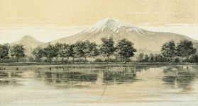
[തിരുത്തുക]18 മുതൽ 19 വരെ നൂറ്റാണ്ടുകളിൽ അർമേനിയ സന്ദർശിച്ച നിരവധി ബ്രിട്ടീഷുകാർ ഉൾപ്പെടെ യൂറോപ്യൻ പുസ്തകങ്ങളിൽ അരരാത്തിനെ ചിത്രീകരിച്ചിട്ടുണ്ട്.
-

-
 റോബർട്ട് കെർ പോർട്ടർ,, 1821
 -
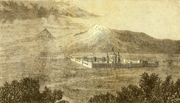 "1846-ൽ ഫ്രീഡ്രിക്ക് പാരറ്റിന്റെ യാത്രയുടെ അരരാത്തിലേക്കുള്ള ഇംഗ്ലീഷ് പരിഭാഷയിൽ നിന്ന്. "അരരാത്തിന്റെ കാഴ്ചയും എക്മിയാഡ്സിൻ മൊണാസ്ട്രിയും"
 -
 ജെയിംസ് ബ്രൈസ്, 1877
 -
 എച്ച്. എഫ്. ബി. ലിഞ്ച്,, 1901


അർമേനിയൻ
[തിരുത്തുക]ഒരു സ്രോതസ്സ് അനുസരിച്ച്, 1868-ൽ അർമേനിയൻ കലാകാരൻ ഇവാൻ ഐവസോവ്സ്കി, [152]അർമേനിയ സന്ദർശനത്തിനിടെ അരരാത്ത് പർവ്വതത്തിന്റെ ആദ്യത്തെ ചിത്രം ചിത്രീകരിച്ചു.[153] അരരാത്ത് ചിത്രീകരിച്ച മറ്റ് പ്രധാന അർമേനിയൻ കലാകാരന്മാരിൽ യെഗിഷെ തദേവോസ്യൻ, ഗെവോർഗ് ബാഷിൻജാഗിയൻ, മാർട്ടിറോസ് സാരിയൻ,[154] പനോസ് ടെർലെമെസിയൻ എന്നിവരും ഉൾപ്പെടുന്നു.
-
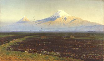
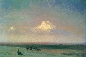 ഇവാൻ ഐവസോവ്സ്കി, അരരാത്ത് പർവ്വതത്തിന്റെ താഴ്വര, 1882
 -
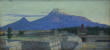 യെഗിഷെ തദേവോസ്യൻ, എജ്മിയാറ്റ്സിനിൽ നിന്നുള്ള അരരാത്ത്, 1895,
 -
 ഗെവോർഗ് ബാഷിൻജാഗിയൻ, 1912
 -
 പനോസ് ടെർലെമെസിയൻ, 1929
.jpg)


.jpg)
സാഹിത്യത്തിൽ
[തിരുത്തുക]"ഭൂമിയിലെ മറ്റേതൊരു പർവ്വതത്തേക്കാളും കൂടുതൽ കവിതകൾ അരരാത്ത് പർവ്വതത്തെക്കുറിച്ച് എഴുതിയിട്ടുണ്ട്" എന്ന് റൂബൻ പോൾ അഡാലിയൻ അഭിപ്രായപ്പെട്ടു.[119] യാത്രാവിവരണ എഴുത്തുകാരൻ റിക്ക് ആന്റൺസൺ അരാരത്തിനെ "ലോകത്തിലെ ഏറ്റവും കെട്ടുകഥയുള്ള പർവ്വതം" എന്ന് വിശേഷിപ്പിച്ചു.[155]
അർമേനിയൻ അല്ലാത്തവർ
[തിരുത്തുക]ഇംഗ്ലീഷ് റൊമാന്റിക് കവി വില്യം വേഡ്സ്വർത്ത് "സ്കൈ-പ്രോസ്പെക്റ്റ് - ഫ്രം ദ പ്ലെയിൻ ഓഫ് ഫ്രാൻസ്" എന്ന കവിതയിൽ പെട്ടകം കണ്ടതായി സങ്കൽപ്പിക്കുന്നു.[156][157]
റുസ്സോ-ടർക്കിഷ് യുദ്ധസമയത്ത് (1828–29) കൊക്കേഷ്യയിലേക്കും അർമേനിയയിലേക്കുമുള്ള തന്റെ യാത്രകളെക്കുറിച്ച് പ്രശസ്ത റഷ്യൻ കവി അലക്സാണ്ടർ പുഷ്കിൻ എ ജേർണി ടു അസ്രമിൽ (Путешествие в Арзрум; 1835–36) പ്രസിദ്ധീകരിച്ചു.
I went out of the tent into the fresh morning air. The sun was rising. Against the clear sky one could see a white-snowcapped, twin-peaked mountain. 'What mountain is that?' I asked, stretching myself, and heard the answer: 'That's Ararat.' What a powerful effect a few syllables can have! Avidly I looked at the Biblical mountain, saw the ark moored to its peak with the hope of regeneration and life, saw both the raven and dove, flying forth, the symbols of punishment and reconciliation...[158]
Aleksandr Pushkin in Journey to Arzrum
റഷ്യൻ പ്രതീകാത്മക കവി വലേരി ബ്രൂസോവ് പലപ്പോഴും തന്റെ കവിതയിൽ അരരാത്തിനെ പരാമർശിക്കുകയും രണ്ട് കവിതകൾ പർവ്വതത്തിനായി സമർപ്പിക്കുകയും ചെയ്തു. [j] 1917-ൽ ഇവ പ്രസിദ്ധീകരിക്കപ്പെട്ടു. അർമേനിയൻ ജനതയുടെ പുരാതനതയുടെയും അവരുടെ സംസ്കാരത്തിന്റെയും പ്രതീകമായി ബ്രയൂസോവ് അരരാത്തിനെ കണ്ടു.[159]
റഷ്യൻ കവി ഒസിപ്പ് മണ്ടൽസ്റ്റാം 1933-ൽ അർമേനിയയിൽ നടത്തിയ യാത്രകളിൽ അരരാത്തിനെക്കുറിച്ച് സ്നേഹപൂർവ്വം എഴുതി. “ഞാൻ ആറാമിന്ത്രിയത്തിന്റെ സഹായത്തോടെ 'അരരാത്തിനെ' ഒരു പർവ്വതത്തോടുള്ള ആകർഷണത്തിന്റെ അവബോധത്തോടെ പഞ്ചേന്ദ്രിയങ്ങളിലോരോന്നിലും വളർത്തിയെടുത്തു,"[160] അർമേനിയയിലേക്കുള്ള യാത്രയ്ക്കിടെ, സോവിയറ്റ് റഷ്യൻ എഴുത്തുകാരൻ വാസിലി ഗ്രോസ്മാൻ യെരേവനിൽ നിന്ന് അരരാത്ത് പർവ്വതം "നീലാകാശത്തിൽ ഉയരത്തിൽ" നിൽക്കുന്നത് നിരീക്ഷിച്ചു. "സൗമ്യവും ആർദ്രവുമായ രൂപരേഖകളാൽ അത് ഭൂമിയിൽ നിന്നല്ല, ആകാശത്ത് നിന്ന് വളരുന്നുവെന്ന് തോന്നുന്നു, അത് വെളുത്ത മേഘങ്ങളിൽ നിന്നും ആഴത്തിലുള്ള നീലയിൽ നിന്നും ഘനീഭവിച്ചതുപോലെ കാണപ്പെട്ടു. മഞ്ഞുവീഴ്ചയുള്ള ഈ പർവ്വതത്തിൽ നീലകലർന്ന വെളുത്ത സൂര്യപ്രകാശമേറ്റപ്പോൾ ബൈബിൾ എഴുതിയവരുടെ കണ്ണിൽ തിളങ്ങിയിരിക്കാം.[161]
ദി മാക്സിമസ് പോയംസ് കവിതകളിൽ (1953) അമേരിക്കൻ കവി ചാൾസ് ഓൾസൺ, മസാച്യുസെറ്റ്സിലെ വോർസെസ്റ്ററിലെ അർമേനിയൻ പരിസരത്തിന് സമീപം വളർന്നതായി പറയുന്നു. തന്റെ ബാല്യകാല വസതിക്ക് സമീപമുള്ള അരരാത്ത് കുന്നിനെ പർവ്വതവുമായി അദ്ദേഹം താരതമ്യം ചെയ്യുന്നു.[162]
ടിം പവേഴ്സ് എഴുതിയ ഡിക്ലെയർ (2001) ലെ നിരവധി പ്രധാന എപ്പിസോഡുകൾ പർവ്വതത്തിലാണ് നടക്കുന്നത്. അരരാത്ത് അമാനുഷിക സംഭവങ്ങളുടെ കേന്ദ്രബിന്ദുവായി പുസ്തകത്തിൽ പ്രതിപാദിക്കുന്നു.
അർമേനിയൻ
[തിരുത്തുക]
അർമേനിയൻ സാഹിത്യത്തിൽ അരരാത്ത് പർവ്വതം പ്രധാന്യത്തോടെ കാണപ്പെടുന്നു. മെലിന കരകാഷിയന്റെ അഭിപ്രായത്തിൽ അർമേനിയൻ കവികൾ "ഐക്യം, സ്വാതന്ത്ര്യം, സ്വയാധികാരം എന്നിവയുടെ പ്രതീകാത്മക അർത്ഥത്തിനായി അരരാത്ത് പർവ്വതത്തെ ഉപയോഗിക്കുന്നു.[163]
കെവൊർക് ബർദക്ജാൻ പറയുന്നതനുസരിച്ച് അർമേനിയൻ സാഹിത്യത്തിൽ അരരാത്തിലൂടെ "അർമേനിയൻ കഷ്ടപ്പാടുകളും അഭിലാഷങ്ങളും പ്രത്യേകിച്ചും 1915-ലെ വംശഹത്യയുടെ അനന്തരഫലങ്ങൾ ഏതാണ്ട് മൊത്തം ഉന്മൂലനം, ഒരു അദ്വിതീയ സംസ്കാരത്തിന്റെയും ഭൂമിയുടെയും നഷ്ടം കൂടാതെ പുതിയ രാഷ്ട്രീയ അതിർത്തികൾ ഒരിക്കലും അംഗീകരിക്കില്ലെന്ന വ്യക്തമായ ദൃഢ നിശ്ചയം" എന്നിവ സംഗ്രഹിക്കുന്നു. [164]
യെഗിഷെ ചാരന്റ്സിന്റെ 1920-ലെ "ഐ ലവ് മൈ അർമേനിയ" (Ես իմ անուշ po) എന്ന കവിതയുടെ അവസാന രണ്ട് വരികൾ ഇങ്ങനെ വായിച്ചു: "ലോകമെമ്പാടും അരരാത്തിന്റേതുപോലുള്ള ഒരു പർവ്വതശിഖരം നിങ്ങൾ കണ്ടെത്തുകയില്ല. എന്റെ മാസിസ് പർവ്വതത്തെ ഞാൻ സ്നേഹിക്കുന്നു"[165]1926-ൽ [166]അവെറ്റിക് ഇഷാക്യാൻ പർവ്വതത്തിനായി സമർപ്പിച്ച കവിതയിൽ എഴുതി: "യുഗങ്ങൾ രണ്ടാം സ്ഥാനത്തെത്തിയതുപോലെ, / അരരാത്തിന്റെ ചാരനിറത്തിലുള്ള കൊടുമുടിയെ സ്പർശിച്ചു, / കടന്നുപോയി ...! ഇപ്പോൾ നിങ്ങളുടെ ഊഴമാണ്; നിങ്ങളും ഇപ്പോൾ, / അതിൻറെ ഗർവ്വുള്ള ഉയർന്ന നെറ്റിയിൽ ഉറ്റുനോക്കുക / കടന്നുപോകുക ...![167]ഹൊഹന്നസ് ഷിറാസിന്റെ കവിതകളിൽ ഏറ്റവും കൂടുതൽ പരാമർശിച്ചിരിക്കുന്ന ചിഹ്നമാണ് അരരാത്ത് പർവ്വതം.[164] 1958-ൽ പ്രസിദ്ധീകരിച്ച ക്നാർ ഹയസ്താനി (അർമേനിയയിലെ ലൈർ) എന്ന കവിതാസമാഹാരത്തിൽ, "വളരെ ശക്തമായ ദേശീയവാദപരമായ പരാമർശങ്ങളുള്ള നിരവധി കവിതകൾ ഉൾക്കൊള്ളുന്നു. പ്രത്യേകിച്ചും അരരാത്ത് പർവ്വതത്തെ (തുർക്കിയിൽ), കുറിച്ചുണ്ടായ ഇറെഡെന്റിസം. അത്തരത്തിലുള്ള ഒരു കവിതയായ "Ktak" (Bequest) ൽ, ഷിറാസ് തന്റെ മകന് ഇഷ്ടദാനം ചെയ്തുകൊണ്ട് "അരരാത്ത് പർവ്വതം എന്നെന്നേക്കുമായി നിലനിർത്താനും, / അർമേനിയക്കാരുടെ ഭാഷയെപ്പോലെയും തങ്ങളുടെ പിതാവിന്റെ വീടിന്റെ തൂണായും കരുതാൻ ആവശ്യപ്പെടുന്നു[168].
ജനപ്രിയ സംസ്കാരത്തിൽ
[തിരുത്തുക]സംഗീതത്തിൽ
[തിരുത്തുക]- "നാല് അർമേനിയൻ അമേരിക്കക്കാർ ഉൾപ്പെടുന്ന ഒരു അമേരിക്കൻ റോക്ക് ബാൻഡായ സിസ്റ്റം ഓഫ് ഡൗൺ എഴുതിയ ഹിപ്നോട്ടിസ് (2005) ആൽബത്തിന്റെ എട്ടാമത്തെ ട്രാക്കായ "ഹോളി മൗണ്ടെയ്ൻസ്", അരരാത്ത് പർവ്വതത്തെ പരാമർശിക്കുന്നു. അർമേനിയൻ വംശഹത്യയുടെ നഷ്ടപ്പെട്ട ആത്മാക്കൾ പർവ്വതത്തിൽ വിശ്രമിക്കാൻ മടങ്ങിയെത്തിയതായി വിവരിക്കുന്നു.",[169]
- ആർട്ടോ ടുണബോയാക്യന്റെ അർമേനിയൻ നേവി ബാൻഡിന്റെ 2006-ലെ ആൽബം ഹൗ മച്ച് ഈസ് യുവർസ് എന്ന ആൽബത്തിലെ ഒരു ഗാനമാണ് ഹിയേഴ്സ് ടു യു അരരാത്ത്.[170]
സിനിമയിൽ
[തിരുത്തുക]- അർമേനിയൻ-കനേഡിയൻ ചലച്ചിത്ര നിർമ്മാതാവ് ആറ്റം എഗോയന്റെ 2002-ൽ പുറത്തിറങ്ങിയ 'അരരാത്ത് എന്ന ചിത്രം അരരാത്ത് പർവ്വതത്തിന്റെ പ്രതീകാത്മകതയിൽ പ്രമുഖമാണ്.[171]
- 2011-ൽ എസ്റ്റോണിയയിലെ ചലച്ചിത്ര നിർമ്മാതാവ് റിഹോ വെസ്ട്രിക് ജേണി ടു അരരാത്ത് ഡോക്യുമെന്ററി ചിത്രം പാരറ്റ്, അബോവിയൻ എന്നിവരുടെ അരരാത്ത് പര്യവേഷണം അടിസ്ഥാനമാക്കി നിർമ്മിച്ചു.[172][173] 2013-ൽ യെരേവനിൽ നടന്ന ഗോൾഡൻ ആപ്രിക്കോട്ട് അന്താരാഷ്ട്ര ചലച്ചിത്രമേളയിൽ ഈ ചിത്രം പ്രദർശിപ്പിച്ചു.[174]
അരരാത്തിന്റെ പേരിൽ പേരിട്ട സ്ഥലങ്ങൾ
[തിരുത്തുക]- അർമേനിയയിൽ, ഒരു പ്രവിശ്യയുണ്ട്, രണ്ട് നഗരങ്ങൾ (അരരാത്ത്, മാസിസ്), രണ്ട് ഗ്രാമങ്ങൾ (അരരാത്ത്, |മാസിസ്) പർവ്വതത്തിന്റെ പേരിലാണ് അറിയപ്പെടുന്നത്.[175]
- തുർക്കി പ്രവിശ്യയായ അഗ്രിı 1927-ൽ പർവ്വതത്തിന് (അതിന്റെ ടർക്കിഷ് നാമം) പേരിട്ടു, പ്രവിശ്യാ തലസ്ഥാന നഗരമായ കരകേസ് 1946-ൽ അഗ്രി എന്നാക്കി മാറ്റി. [176]
- അമേരിക്കൻ ഐക്യനാടുകളിൽ, വിർജീനിയയിലെയും നോർത്ത് കരോലിനയിലെയും ഒരു നദിക്ക് 1770-ന് ശേഷം പർവ്വതത്തിന്റെ പേര് നൽകി. നോർത്ത് കരോലിനയിലെ ഒരു ഇൻകോർപ്പറേറ്റ് ചെയ്യപ്പെടാത്ത ഒരു കമ്മ്യൂണിറ്റിക്ക് പിന്നീട് നദിയുടെ പേര് നൽകി.[177] പെൻസിൽവാനിയയിൽ ഒരു ടൗൺഷിപ്പും പർവ്വതത്തിന്റെ പേരിൽ അറിയപ്പെടുന്നു[178]
- ഓസ്ട്രേലിയൻ സംസ്ഥാനമായ വിക്ടോറിയയിൽ 1840 ൽ ഒരു നഗരത്തിന് അരരാത്ത് എന്ന് പേരിട്ടു. ഇതിന്റെ പ്രാദേശിക സർക്കാർ പ്രദേശത്തെ അരരാത്ത് എന്നും വിളിക്കുന്നു.[179][180]
- പർവ്വതത്തിന്റെ ബഹുമാനാർത്ഥം പേരിട്ടിരിക്കുന്ന ഒരു ഛിന്നഗ്രഹമാണ് 96205 അരരാത്ത്.1992-ൽ ജർമ്മനിയിലെ ടൗട്ടൻബർഗ് ഒബ്സർവേറ്ററിയിൽ ഫ്രീമുട്ട് ബർഗെൻ, Lutz D. Schmadelലൂത്സ് ഡി. ഷ്മഡെൽ എന്നിവർ ഇത് കണ്ടെത്തി. ബർഗെൻ ആണ് ഈ പേര് നിർദ്ദേശിച്ചത്.[181]
സംസ്ഥാനങ്ങൾ
[തിരുത്തുക]- അരരാത്ത് യുറാർട്ടുവിന്റെ എബ്രായ പതിപ്പിനു പുറമേ, [14] ഇരുമ്പുയുഗത്തിൽ അർമേനിയൻ ചരിത്ര പഠനത്തിലും അതിന്റെ രചനയിലും "അരാരേഷ്യൻ രാജ്യം" അല്ലെങ്കിൽ "അരരാത്ത് രാജ്യം" (അർമേനിയൻ: Արարատյան թագավորություն, Arartyan t’agavorut’yun) എന്നും വിളിച്ചിരുന്നു. [182]ഈ പുരാതന സംസ്ഥാനത്തിന് ഈ പേര് ബൈബിൾ സംബന്ധിയായ ഒരു അർമേനിയൻ സ്പർശവും നൽകുന്നുവെന്ന് ലെവൺ അബ്രഹാമിയൻ അഭിപ്രായപ്പെട്ടു[183]
- 1918 നും 1920 നും ഇടയിൽ നിലവിലുണ്ടായിരുന്ന ആദ്യത്തെ ആധുനിക അർമേനിയൻ രാഷ്ട്രമായ ഫസ്റ്റ് റിപ്പബ്ലിക്, ചിലപ്പോൾ അരരാത്തിയൻ റിപ്പബ്ലിക് അല്ലെങ്കിൽ അരരാത്ത് റിപ്പബ്ലിക് (Armenian: Արարատյան Հանրապետություն, Araratyan hanrapetut’yun)[184][185] അരരാത്ത് സമതലത്തിൽ കേന്ദ്രീകരിച്ചിരിക്കുന്നു.[186][187]
- 1927-ൽ തുർക്കി സർക്കാരിനെതിരെ ഒരു പ്രക്ഷോഭത്തിനെതിരെ പോരാടിയ ഇഹ്സാൻ നൂരിയുടെ നേതൃത്വത്തിലുള്ള കുർദിഷ് ദേശീയ പാർട്ടി സോയ്ബാൻ റിപ്പബ്ലിക് ഓഫ് അരരാത്തിന്റെ (കുർദിഷ്: കൊമാര അഗിരിയ) പർവ്വതം കേന്ദ്രീകരിച്ച് സ്വാതന്ത്ര്യം പ്രഖ്യാപിച്ചു.[188][189]
ചിത്രശാല
[തിരുത്തുക]-
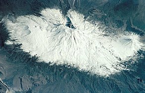
 2011 ജൂലൈ 8 ന് അന്താരാഷ്ട്ര ബഹിരാകാശ നിലയത്തിൽ നിന്ന് എടുത്ത ചിത്രം.
 -
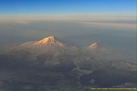
 2001 മാർച്ച് 18 ന് ബഹിരാകാശവാഹനത്തിൽ നിന്ന് എടുത്ത ചിത്രം.
 -
-
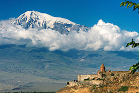
 അർമേനിയയിലെ ഖോർ വിരാപ്പിൽ നിന്നുള്ള അരറാത്തിന്റെ കാഴ്ച.
 -
 View of Ararat with the Khor Virap in the front, Armenia
 -
 View of Ararat from Iğdır, Turkey
 -
 from Doğubeyazıt
 -
 from Iğdır
 -
 from Nakhchivan


അവലംബം
[തിരുത്തുക]Notes
[തിരുത്തുക]- ↑ Strabo, Geographica, XI.14.2 and XI.14.14.[24] They are also transliterated as Abus and Nibarus.[25] Abos and Nibaros are the two peaks of Ararat according to scholars such as Nicholas Adontz,[24] Vladimir Minorsky,[26] Julius Fürst.[27]
- ↑
- Richard James Fischer: "The Genesis text, using the plural 'mountains' (or hills), identifies no particular mountain, but points generally toward Armenia ('Ararat' being identical with the Assyrian 'Urartu') which is broadly embraces [sic] that region."[78]
- Exell, Joseph S.; Spence-Jones, Henry Donald Maurice (eds.). "Genesis". The Pulpit Commentary.
It is agreed by all that the term Ararat describes a region.
view online - Dummelow, John, ed. (1909). "Genesis". John Dummelow's Commentary on the Bible.
Ararat is the Assyrian 'Urardhu,' the country round Lake Van, in what is now called Armenia… and perhaps it is a general expression for the hilly country which lay to the N. of Assyria. Mt. Masis, now called Mt. Ararat (a peak 17,000 ft. high), is not meant here.
view online - Bill T. Arnold: "Since the ancient kingdom of Ararat/Urartu was much more extensive geographically than this isolated location in Armenia, modern attempts to find remaints of Noah's ark here are misguided."[79]
- Vahan Kurkjian: "It has long been the notion among many Christians that Noah's Ark came to rest as the Flood subsided upon the great peak known as Mount Ararat; this assumption is based upon an erroneous reading of the 4th verse of the VIIIth chapter of Genesis. That verse does not say that the Ark landed upon Mount Ararat, but upon 'the mountains of Ararat.' Now, Ararat was the Hebrew version of the name, not of the mountain but of the country around it, the old Armenian homeland, whose name at other times and in other tongues appears variously as Erirath, Urartu, etc."[80]
- ↑ Armenians have been called the "people of Ararat" by authors of at least two books.[109][110] Italian diplomat and historian Luigi Villari wrote in 1906: "Almost the whole history of the Armenian people centres round Mount Ararat."[111]
- ↑ "...Mt. Ararat, which was the geographical center of the ancient Armenian kingdoms..."[120]
- ↑ "The lands of Western Armenia which Mt. Ararat represent..."[124] "mount Ararat is the symbol of banal irredentism for the territories of Western Armenia"[132]
- ↑ Hofmann suggested that "the return of the ruins of Ani and of Mount Ararat [by Turkey to Armenia], both in the immediate border area could be considered as a convincing gesture of Turkey's apologies and will for reconciliation."[143]
- ↑ Mikloško stated at a 2010 conference on Turkey's foreign policy: "Mount Ararat [represents the] Christian heritage of Armenians. Does modern Turkey consider the possibility of giving the mount back to Armenians? The return of Ararat would be an unprecedented step to signify Turkey’s willingness to build a peaceful future and promote its image at the international scene."[144]
- ↑ Štromas wrote: "The Armenians would also be right to claim from Turkey the Ararat Valley, which is an indivisible part of the Armenian homeland containing the main spiritual center and supreme symbol of Armenia's nationhood, the holy Mountain of Ararat itself."[145]
- ↑ Central Bank of the Republic of Turkey. Banknote Museum: 6. Emission Group – One Hundred Turkish Lira – I. Series, II. Series & III. Series.
- ↑ "К Арарату" ("To Ararat") and "Арарат из Эривани" ("Ararat from Erivan")
അവലംബം
[തിരുത്തുക]- ↑ "100 World Mountains ranked by primary factor". ii.uib.no. Institutt for informatikk University of Bergen.
- ↑ Bjørstad, Petter E. (August 2007). "Ararat Trip Report". ii.uib.no. University of Bergen. Archived from the original on 21 October 2017.
- ↑ "Ağrı Dağı Milli Parkı [Ağrı Dağı National Park]". ormansu.gov.tr (in ടർക്കിഷ്). Republic of Turkey Ministry of Forest and Water Management. Archived from the original on 2014-08-08. Retrieved 2019-09-17. Archived 2014-08-08 at the Wayback Machine.
- ↑ "Ararat". Merriam-Webster.
\ˈer-ə-ˌrat, ˈa-rə-\
; "Ararat". Collins Dictionary.ˈærəˌræt
- ↑ 5.0 5.1 5.2 5.3 5.4 5.5 5.6 5.7 5.8 Yilmaz, Y.; Güner, Y.; Saroğlu, F. (1998). "Geology of the quaternary volcanic centres of the east Anatolia". Journal of Volcanology and Geothermal Research. 85 (1–4): 173–210. Bibcode:1998JVGR...85..173Y. doi:10.1016/s0377-0273(98)00055-9.
- ↑ Short, Nicholas M.; Blair, Robert W., eds. (1986). "Mt. Ararat, Turkey". Geomorphology From Space: A Global Overview of Regional Landforms. National Aeronautics and Space Administration. p. 226.
- ↑ 7.0 7.1 de Planhol, X. (1986). "Ararat". Encyclopædia Iranica.
- ↑ Hovannisian, Richard G. (1973). "Armenia and the Caucasus in the Genesis of the Soviet-Turkish Entente". International Journal of Middle East Studies. 4 (2): 129–147. doi:10.1017/s0020743800027409. JSTOR 162238.
...Nationalist Turkey annexed the Surmalu district, embracing Mount Ararat, the historic symbol of the Armenian people.
- ↑ de Waal, Thomas (2015). Great Catastrophe: Armenians and Turks in the Shadow of Genocide. Oxford University Press. p. 86. ISBN 978-0199350698.
- ↑ 10.0 10.1 Parrot 2016, p. xxiii.
- ↑ Yildiz, Kerim; Taysi, Tanyel B. (2007). The Kurds in Iran: The Past, Present and Future. London: Pluto Press. p. 71. ISBN 978-0745326696.
- ↑ Tsutsiev, Arthur (2014). Atlas of the Ethno-Political History of the Caucasus. Translated by Nora Seligman Favorov. New Haven: Yale University Press. p. 92. ISBN 978-0300153088.
- ↑ Westerman, Frank (2008-12-02). Ararat: In Search of the Mythical Mountain. Random House. ISBN 978-1-4070-1951-2.
- ↑ 14.0 14.1 14.2 Arnold 2008, p. 104.
- ↑ Frymer, Tikva S.; Sperling, S. David (2008). "Ararat, Armenia". Encyclopaedia Judaica (2nd ed.). view online Archived 2016-05-12 at the Wayback Machine.
- ↑ Petrosyan 2016, p. 68.
- ↑ Rogers, Thorold (1884). Bible Folk-Lore: A Study in Comparative Methodology. London: Kegan Paul, Trench, Trübner & Co. p. 21.
Ararat was thought by Gesenius to be a Sanskrit word (Arjawartah), signifying "holy ground,"...
- ↑ Bonomi, Joseph (1866). "Ararat". In Fairbairn, Patrick (ed.). The Imperial Bible-Dictionary: Historical, Biographical, Geographical and Doctrinal - Volume I. Glasgow: Blackie and Son. p. 118.
- ↑ 19.0 19.1 Avakyan, K. R. (2009). "Աշոտ Մելքոնյան, Արարատ. Հայոց անմահության խորհուրդը [Ashot Melkonyan, Ararat. Symbol of Armenian Immortality]". Lraber Hasarakakan Gitutyunneri (in അർമേനിയൻ). № 1 (1): 252–257. Archived from the original on 2015-11-18. Retrieved 2015-11-17.
Պատմական ճակատագրի բերումով Արարատ-Մասիսը ոչ միայն վեհության, անհասանելիության, կատարելության մարմնավորում է, այլև 1915 թ. հայոց մեծ եղեռնից ու հայ ժողովրդի հայրենազրկումից հետո՝ բռնազավթված հայրենիքի և այն նորեն իր արդար զավակներին վերադարձելու համոզումի անկրկնելի խորհրդանիշ, աշխարհասփյուռ հայության միասնականության փարոս» (էջ 8):
{{cite journal}}:|volume=has extra text (help) - ↑ Teryan, Anzhela (31 August 2011). "Երևան անվան ծագման մասին [On the origin of the name Yerevan]" (in അർമേനിയൻ). Yerevan History Museum. Archived from the original on 7 June 2018.
Հայտնի է, որ Հայկական լեռնաշխարհում Ար-ով /նաև էր, Ուր, Իր/ սկսվող բազմաթիվ աշխարհագրական (նաև անձնական) անուններ կան. Արարատ, Արագած, Արա, Արաքս, Արածանի, Արմավիր, Արճեշ…: Այս երևույթը կապված է Արարչի /Ար Աստված/ և նրա պաշտանմունքն ունեցող Հայկական լեռնաշխարհի բնիկների՝ հայ-արմենների՝ արմեն, նաև արի /Էրի/ անվան հետ:
- ↑ 21.0 21.1 21.2 Hewsen, Robert H. (2001). "Armenia: The Physical Setting—Mt. Ararat". Armenia: A Historical Atlas. University of Chicago Press. p. 15. ISBN 978-0-226-33228-4.
- ↑ Smith, Eli (1832). "Foreign Correspondence". The Biblical Repository and Classical Review: 203.
...called by the Armenians, Masis, and by Europeans generally Ararat...
- ↑ 23.0 23.1 Bryce 1877, p. 198.
- ↑ 24.0 24.1 Petrossyan 2010, p. 220.
- ↑ Jones, Horace Leonard, ed. (1928). "XI.14". The Geography of Strabo. Harvard University Press. view Book XI, Chapter 14 online
- ↑ Minorsky, V. (1944). "Roman and Byzantine Campaigns in Atropatene". Bulletin of the School of Oriental and African Studies, University of London. 11 (2): 243–265. doi:10.1017/S0041977X0007244X. JSTOR 609312.
Although what Strabo means by Abos seems to be the southern spurs of Mt. Ararat...
- ↑ Julius Fürst cited in Exell, Joseph; Jones, William; Barlow, George; Scott, W. Frank; et al. (1892). The Preacher's Complete Homiletical Commentary. "...the present Aghri Dagh or the great Ararat (Pers. Kuhi Nuch, i.e. Noah's mountain, in the classics ὁ ἄβος, Armen. massis)..." (Furst.) view online
- ↑ 28.0 28.1 Jastrow Jr., Morris; Kent, Charles Foster (1902). "Ararat". Jewish Encyclopedia Volume II. New York: Funk & Wagnalls Co. p. 73.
The mountain itself is known as Ararat only among Occidental geographers. The Armenians call it Massis, the Turks Aghri Dagh, and the Persians Koh i Nuh, or "the mountain of Noah."
view online - ↑ Avetisyan, Kamsar (1979). Հայրենագիտական էտյուդներ [Armenian studies sketches] (in അർമേനിയൻ). Yerevan: Sovetakan grogh. p. 14. Archived from the original on 2015-11-27. Retrieved 2015-11-24.
Հայերը Արարատը անվանում են Մասիս...
- ↑ Khorenatsi 1978, p. 91.
- ↑ 31.0 31.1 Petrossyan 2010, p. 221.
- ↑ 32.0 32.1 32.2 Novoseltsev 1978.
- ↑ Petrosyan 2016, p. 72.
- ↑ Armen Petrosyan. "Biblical Mt. Ararat: Two Identifications." Comparative Mythology. December 2016. Vol. 2. Issue 1. pp. 68-80.
- ↑ Dalton, Robert H. (2004). Sacred Places of the World: A Religious Journey Across the Globe. Abhishek. p. 133. ISBN 9788182470514.
The Turkish name for Mt Ararat is Agri Dagi (which means mountain of pain).
- ↑ McCarta, Robertson (1992). Turkey (2nd ed.). Nelles. p. 210. ISBN 9783886184019.
(Turkish: Agri Dagi, "Mount of Sorrows")
- ↑ 37.0 37.1 Sarıkaya, Mehmet Akif (2012). "Recession of the ice cap on Mount Ağrı (Ararat), Turkey, from 1976 to 2011 and its climatic significance". Journal of Asian Earth Sciences. 46: 190–194. Bibcode:2012JAESc..46..190S. doi:10.1016/j.jseaes.2011.12.009.
- ↑ "Xortekî tirk dixwaze bi bîsîklêtê xwe ji çiyayê Agirî berde xwarê" (in കുർദ്ദിഷ്). Rudaw Media Network. 19 June 2014. Archived from the original on 17 November 2015. Retrieved 16 November 2015.
- ↑ Waugh, Alexander (27 August 2008). "Will he, won't He? Ararat by Frank Westerman, translated by Sam Garrett". The Spectator. Archived from the original on 11 August 2016. Retrieved 22 June 2016.
- ↑ "Ağrı – Mount Ararat". Republic of Turkey Ministry of culture and tourism (kultur.gov.tr). 2005.
- ↑ "Mount Agri (Ararat)". anatolia.com. 2003. Archived from the original on 2021-09-28. Retrieved 26 December 2020.
the Serdarbulak lava plateau (2600 m) stretches out between the two pinnacles.
- ↑ Merriam-Webster's Geographical Dictionary (3rd ed.). Springfield, Massachusetts: Merriam-Webster. 2001. p. [https://books.google.com/books?id=Co_VIPIJerIC&pg=PA63 63]. ISBN 9780877795469.
- ↑ Haggett, Peter, ed. (2002). "Turkey". Encyclopedia of World Geography: The Middle East (2nd ed.). Marshall Cavendish. p. 2026. ISBN 978-0-7614-7289-6.
- ↑ Hartemann, Frederic; Hauptman, Robert (2005). The Mountain Encyclopedia. Lanham, Maryland: Taylor Trade. p. [https://books.google.com/books?id=ifs2AgAAQBAJ&pg=PA17 17]. ISBN 978-0-8108-5056-9.
- ↑ Galichian, Rouben (2004). Historic Maps of Armenia: The Cartographic Heritage. I.B. Tauris. p. 26. ISBN 978-1-86064-979-0.
- ↑ Kurter, Ajun [in ടർക്കിഷ്] (20 May 1988). "Glaciers of the Middle East and Africa: Turkey" (PDF). United States Geological Survey Professional Paper. Archived from the original on 11 October 2017.
{{cite journal}}: Cite journal requires|journal=(help)CS1 maint: bot: original URL status unknown (link) - ↑ "Maps of Ararat - Ararat Map, Turkey (Agri Dagi)". turkeyodyssey.com. Terra Anatolia. Archived from the original on 2007-02-25. Archived 2007-02-25 at the Wayback Machine.
- ↑ According to Petter E. Bjørstad, Head of Informatics Department at the University of Bergen (Norway). "Ararat Trip Report". ii.uib.no. August 2007. Archived from the original on 11 October 2017.
I measured the summit elevation, averaging more than 300 samples in my GPS, it settled on 5132 meter, 5 meter lower than the often quoted 5137 figure. This clearly shows that the 5165 meter elevation that many sources use is wrong. The summit is a snow ridge with no visible rock anywhere. Thus, the precise elevation will change with the seasons and could definitely be influenced by climate change (global warming). Later GPS measurements in Iran suggested that the GPS data may be about 10 meter too high also in this part of the world. This would in fact point in the direction of a true Ararat elevation around 5125 meter.
- ↑ 49.0 49.1 49.2 Blumenthal, M. M. (1958). "Vom Agrl Dag (Ararat) zum Kagkar Dag. Bergfahrten in nordostanatolischen Grenzlande". Die Alpen (in ജർമ്മൻ). 34: 125–137.
- ↑ 50.0 50.1 Sarıkaya, Mehmet Akif; Tekeli, A. E. (2014). "Satellite inventory of glaciers in Turkey". In J. S. Kargel; et al. (eds.). Global Land Ice Measurements from Space. New York: Springer-Verlag. pp. 465–480. ISBN 978-3540798170.
- ↑ 51.0 51.1 Birman, J. H. (1968). "Glacial Reconnaissance in Turkey". Geological Society of America Bulletin. 79 (8): 1009–1026. Bibcode:1968GSAB...79.1009B. doi:10.1130/0016-7606(1968)79[1009:GRIT]2.0.CO;2.
- ↑ 52.0 52.1 Dewey, J. F.; Hempton, M. R.; Kidd, W. S. F.; Saroglum, F.; Sengὃr, A. M. C. (1986). "Shortening of continental lithosphere: the neotectonics of Eastern Anatolia – a young collision zone". In Coward, M. P.; Ries, A. C. (eds.). Collision Tectonics. Geological Society of London. pp. 3–36.
- ↑ 53.0 53.1 53.2 53.3 Karakhanian, A.; Djrbashian, R.; Trifonov, V.; Philip, H.; Arakelian, S.; Avagian, A. (2002). "Holocene–Historical Volcanism and Active Faults as Natural Risk Factor for Armenia and Adjacent Countries". Journal of Volcanology and Geothermal Research. 113 (1): 319–344. Bibcode:2002JVGR..113..319K. doi:10.1016/s0377-0273(01)00264-5.
- ↑ 54.0 54.1 54.2 54.3 Karakhanian, A.S.; Trifonov, V.G.; Philip, H.; Avagyan, A.; Hessami, K.; Jamali, F.; Bayraktutan, M. S.; Bagdassarian, H.; Arakelian, S.; Davtian, V.; Adilkhanyan, A. (2004). "Active faulting and natural hazards in Armenia, Eastern Turkey and North-Western Iran". Tectonophysics. 380 (3–4): 189–219. Bibcode:2004Tectp.380..189K. doi:10.1016/j.tecto.2003.09.020.
- ↑ Allen, Mark B.; Mark, Darren F.; Kheirkhah, Monireh; Barfod, Dan; Emami, Mohammad H.; Saville, Christopher (2011). "40Ar/39Ar dating of Quaternary lavas in northwest Iran: constraints on the landscape evolution and incision rates of the Turkish–Iranian plateau" (PDF). Geophysical Journal International. 185 (3): 1175–1188. Bibcode:2011GeoJI.185.1175A. doi:10.1111/j.1365-246x.2011.05022.x.
- ↑ 56.0 56.1 Siebert, L., T. Simkin, and P. Kimberly (2010) Volcanoes of the world, 3rd ed. University of California Press, Berkeley, California. 551 pp. ISBN 978-0-520-26877-7.
- ↑ 57.0 57.1 Haroutiunian, R. A. (2005). "Катастрофическое извержение вулкана Арарат 2 июля 1840 года [Catastrophic eruption of volcano Ararat on 2 july, 1840]". Proceedings of the National Academy of Sciences of the Republic of Armenia: Earth Sciences (in റഷ്യൻ). 58 (1): 27–35. ISSN 0515-961X. Archived from the original on 2015-12-07. Retrieved 2019-09-17.
- ↑ Taymaz, Tuncay; Eyidog̃an, Haluk; Jackson, James (1991). "Source parameters of large earthquakes in the East Anatolian fault zone (Turkey)". Geophysical Journal International. 106 (3): 537–550. Bibcode:1991GeoJI.106..537T. doi:10.1111/j.1365-246x.1991.tb06328.x.
- ↑ 59.0 59.1 William of Rubruck (1998). The Journey of William of Rubruck to the Eastern Parts of the World, 1253–55. Translated by W. W. Rockhill. New Delhi: Asian Educational Services. p. 269–270. ISBN 978-81-206-1338-6.
[...] mountains in which they say that Noah's ark rests; and there are two mountains, the one greater than the other; and the Araxes flows at their base [...] Many have tried to climb it, but none has been able. [...] An old man gave me quite a good reason why one ought not to try to climb it. They call the mountain Massis [...] "No one," he said, "ought to climb up Massis; it is the mother of the world."
- ↑ Stackhouse, Thomas (1836). A History of the Holy Bible. Glasgow: Blackie and Son. p. 93.
- ↑ Siekierski, Konrad (2014). ""One Nation, One Faith, One Church": The Armenian Apostolic Church and the Ethno-Religion in Post-Soviet Armenia". In Agadjanian, Alexander (ed.). Armenian Christianity Today: Identity Politics and Popular Practice. Ashgate Publishing. p. 14. ISBN 978-1-4724-1273-7.
- ↑ Parrot 2016, p. 139
- ↑ Randveer, Lauri (October 2009). "How the Future Rector Conquered Ararat". University of Tartu. Archived from the original on 2015-11-25. Retrieved 2015-11-25.
- ↑ Khachaturian, Lisa (2011). Cultivating Nationhood in Imperial Russia: The Periodical Press and the Formation of a Modern Armenian Identity. Transaction Publishers. p. 52. ISBN 978-1-4128-1372-3.
- ↑ Milner, Thomas (1872). The Gallery of Geography: A Pictorial and Descriptive Tour of the World, Volume 2. W.R. M'Phun & Son. p. 783.
Great Ararat was ascended for the first time by Professor Parrot, October 9, 1829...
- ↑ Giles, Thomas (27 April 2016). "Friedrich Parrot: The man who became the 'father of Russian mountaineering'". Russia Beyond the Headlines. Archived from the original on 24 June 2018. Retrieved 19 April 2017.
- ↑ Parrot 2016, p. 142.
- ↑ Parrot 2016, p. 141-142.
- ↑ Parrot 2016, p. 183.
- ↑ Fairbairn, Patrick (1866). "Ararat". The Imperial Bible-Dictionary: Historical, Biographical, Geographical and Doctrinal – Volume I. p. 119.
- ↑ Polo, Marco; Yule, Henry (2010). The Book of Ser Marco Polo, the Venetian: Concerning the Kingdoms and Marvels of the East, Volume 1. Cambridge University Press. p. 49. ISBN 978-1-108-02206-4.
- ↑ 72.0 72.1 Bryce, James (1878). "On Armenia and Mount Ararat". Proceedings of the Royal Geographical Society of London. 22 (3): 169–186. doi:10.2307/1799899. JSTOR 1799899.
- ↑ Lynch, H. F. B. (1893). "The ascent of Ararat". The Geographical Journal. 2: 458.
- ↑ Lynch, H. F. B. (1901). Armenia, travels and studies. Volume I: The Russian Provinces. London: Longmans, Green, and Co. p. 176.
- ↑ "Conquering the legendary Mount Ararat". Hürriyet Daily News. 15 January 2006. Archived from the original on 2014-02-22. Retrieved 2019-09-24.
{{cite news}}: CS1 maint: bot: original URL status unknown (link) - ↑ Spar, Ira (2003). "The Mesopotamian Legacy: Origins of the Genesis tradition". In Aruz, Joan (ed.). Art of the First Cities: The Third Millennium B.C. from the Mediterranean to the Indus. New York: Metropolitan Museum of Art. p. 488. ISBN 978-1-58839-043-1. Archived from the original on 2015-11-29. Retrieved 2015-11-08.
- ↑ Morgenstern, Julian (1941). "Psalm 48". Hebrew Union College Annual. 16: 1–95. JSTOR 23502992.
Note the plural, hare 'Ararat; not "Mt. Ararat," as traditionally translated and interpreted, but rather "(one of) the mountains of Ararat," i. e. of Urartu or Armenia.
- ↑ 78.0 78.1 Richard James Fischer (2007). "Mount Ararat". Historical Genesis: From Adam to Abraham. University Press of America. pp. 109–111. ISBN 9780761838074.
- ↑ 79.0 79.1 Arnold 2008, p. 105.
- ↑ Kurkjian, Vahan (1964) [1958]. A History of Armenia. New York: Armenian General Benevolent Union of America. p. 2.
- ↑ Room, Adrian (1997). Placenames of the World: Origins and Meanings. McFarland. p. 34. ISBN 9780786401727.
- ↑ 82.0 82.1 82.2 Vos, Howard F. (1982). "Flood (Genesis)". In Bromiley, Geoffrey W. (ed.). International Standard Bible Encyclopedia: E-J (fully revised ed.). Wm. B. Eerdmans Publishing. p. 319. ISBN 978-0-8028-3782-0.
- ↑ Tremblais, Jean-Louis (16 July 2011). "Ararat, montagne biblique". Le Figaro (in ഫ്രഞ്ച്). Archived from the original on 17 November 2015. Retrieved 9 November 2015.
- "Biblical mountain's glaciers shrinking". News24. 8 August 2010. Archived from the original on 17 November 2015. Retrieved 16 November 2015.
- ↑ 84.0 84.1 Avagyan, Ṛafayel (1998). Yerevan—heart of Armenia: meetings on the roads of time. Union of Writers of Armenia. p. 17.
The sacred biblical mountain prevailing over Yerevan was the very visiting card by which foreigners came to know our country.
- ↑ Bailey, Lloyd R. (1990). "Ararat". In Mills, Watson E.; Bullard, Roger Aubrey (eds.). Mercer Dictionary of the Bible. Mercer University Press. p. 54. ISBN 978-0-86554-373-7. Archived from the original on 2019-01-28. Retrieved 2016-11-03.
...the local (Armenian) population called Masis and which they began to identify as the ark's landing place in the eleventh-twelfth centuries.
- ↑ Conybeare, F. C. (1901). "Reviewed Work: Ararat und Masis. Studien zur armenischen Altertumskunde und Litteratur by Friedrich Murad". The American Journal of Theology. 5 (2): 335–337. doi:10.1086/477703. JSTOR 3152410.
- ↑ 87.0 87.1 Spencer, Lee; Lienard, Jean Luc (2005). "The Search for Noah's Ark". Southwestern Adventist University. (archived)
- ↑ Mandeville, John (2012). The Book of Marvels and Travels. Translated by Anthony Bale. Oxford University Press. p. 70. ISBN 9780199600601.
- ↑ Mandel, Jerome (2013). "Ararat, Mount". In Friedman, John Block; Figg, Kristen Mossler (eds.). Trade, Travel, and Exploration in the Middle Ages: An Encyclopedia. Routledge. p. 30. ISBN 978-1-135-59094-9.
- ↑ "Նոյն իջնում է Արարատից (1889) [Descent of Noah from Ararat (1889)]" (in അർമേനിയൻ). National Gallery of Armenia. Archived from the original on 2015-09-24. Retrieved 2015-11-03.
- ↑ Conway Morris, Roderick (24 February 2012). "The Key to Armenia's Survival". The New York Times. Archived from the original on 7 March 2017. Retrieved 11 February 2017.
- ↑ 92.0 92.1 original title: Dictionnaire historique, critique, chronologique, geographique et literal de la Bible. English translation: Calmet, Augustin (1830). "Ararat". Calmet's Dictionary of the Holy Bible: With the Biblical Fragments, Volume 1. Charles Taylor (translator). London: Holdsworth and Ball. p. 178–179.
- ↑ Jamieson, Robert; Fausset, Andrew Robert; Brown, David (1871). Commentary Critical and Explanatory on the Whole Bible. view Genesis 8:4 commentary online Archived 2016-08-20 at the Wayback Machine.
- ↑ Dwight 1856, p. 189:
- ↑ "Homily of John Paul II". vatican.va. Holy See. 26 September 2001. Archived from the original on 19 December 2016.
{{cite web}}: CS1 maint: bot: original URL status unknown (link) - ↑ "Приветственная речь Святейшего Патриарха Кирилла в кафедральном соборе Эчмиадзина [Welcome speech by His Holiness Patriarch Kirill at the Cathedral of Etchmiadzin]". patriarchia.ru (in റഷ്യൻ). Russian Orthodox Church. 16 March 2010. Archived from the original on 19 December 2016.
Каждый, кто приезжает в Армению, получает неизгладимое впечатление, лицезрея ее главный символ — священную гору Арарат, на которой остановился после потопа ковчег праотца Ноя.
{{cite web}}: CS1 maint: bot: original URL status unknown (link) - ↑ Patai, Raphael; Oettinger, Ayelet (2015). "Ararat". In Patai, Raphael; Bar-Itzhak, Haya (eds.). Encyclopedia of Jewish Folklore and Traditions. Routledge. pp. 50–51. ISBN 9780765620255.
- ↑ Balsiger, David; Sellier Jr., Charles E. (1974). In Search of Noah's Ark. Sunn Classic Books. p. 203.
- ↑ Zenian, David (1 July 1996). "The Holy Etchmiadzin Museum: History of a Long Journey". AGBU Magazine. Archived from the original on 22 October 2017. Retrieved 11 October 2017.
- ↑ Mayell, Hillary (27 April 2004). "Noah's Ark Found? Turkey Expedition Planned for Summer". National Geographic. pp. 1, 2. Archived from the original on 14 April 2010. Retrieved 26 November 2015.
- ↑ Cline, Eric H. (2009). Biblical Archaeology: A Very Short Introduction. Oxford University Press. p. 72. ISBN 978-0-19-534263-5.
- ↑ Fagan, Garrett G. (2006). Archaeological Fantasies: How Pseudoarchaeology Misrepresents the Past and Misleads the Public. Psychology Press. p. 69. ISBN 978-0-415-30592-1.
- ↑ Feder, Kenneth L. (2010). "Noah's Ark". Encyclopedia of Dubious Archaeology: From Atlantis to the Walam Olum: From Atlantis to the Walam Olum. ABC-CLIO. pp. [https://books.google.com/books?id=RlRz2symkAsC&pg=PT195 195–196]. ISBN 978-0-313-37919-2.
- ↑ Peroomian, Rubina (2007). "Historical Memory: Threading the Contemporary Literature of Armenia". In Hovannisian, Richard (ed.). The Armenian Genocide: Cultural and Ethical Legacies. Transaction Publishers. p. 113. ISBN 9781412835923.
...the majestic duo of Sis and Masis (the two peaks of Mount Ararat) that hover above the Erevan landscape are constant reminders of the historical injustice.
- ↑ 105.0 105.1 Boniface, Brian; Cooper, Chris; Cooper, Robyn (2012). Worldwide Destinations: The Geography of Travel and Tourism (6th ed.). Taylor & Francis. p. 338. ISBN 978-0-415-52277-9.
The snow-capped peak of Ararat is a holy mountain and national symbol for Armenians, dominating the horizon in the capital, Erevan, yet it is virtually inaccessible as it lies across the border in Turkey.
- ↑ Lydolph, Paul E. (1979). Geography of the U.S.S.R., Topical Analysis. Misty Valley Publishing. p. 46.
...about 65 kilometers south of Yerevan where Mount Ararat reaches an elevation of 5156 meters.
- ↑ Shoemaker, M. Wesley (2014). "Armenia". Russia and The Commonwealth of Independent States 2014. Rowman & Littlefield. p. 203. ISBN 9781475812268.
Mt. Ararat, traditionally associated with Armenia...
- ↑ Walker, Christopher J. (1990) [1980]. Armenia: The Survival of a Nation (2nd ed.). New York: St. Martin's Press. p. 11. ISBN 978-0-312-04230-1.
...Mount Ararat, closely identified with Armenia throughout her history...
- ↑ Gabrielian, M. C. (1892). The Armenians: or the People of Ararat. Philadelphia: Allen, Lane & Scott. Archived from the original on 2015-02-01. Retrieved 2016-06-12.
- ↑ Burtt, Joseph (1926). The People of Ararat. London: L. and Virginia Woolf at the Hogarth Press. OCLC 3522299.
- ↑ Villari, Luigi (1906). Fire and Sword in the Caucasus. London: T. Fisher Unwin. p. 215.
- ↑ Levonian Cole, Teresa (30 October 2010). "Armenia opens up to visitors". Financial Times. Archived from the original on 17 November 2015. Retrieved 16 November 2015.
Ararat, the supreme symbol of Armenia...
- ↑ Boltyansky, Boris (24 October 2015). "Солнце мое" (in റഷ്യൻ). lenta.ru. Archived from the original on 19 November 2015. Retrieved 9 November 2015.
Библейский Арарат, символ страны, стал главным брендом Армении.
- ↑ Adriaans 2011, p. 35.
- ↑ Darieva, Tsypylma (2006). "Bringing the soil back to the homeland: Reconfigurations of representation of loss in Armenia" (PDF). Comparativ: Leipziger Beiträge zur Universalgeschichte und Vergleichenden Gesellschaftsforschung (3): 90. Archived from the original on 2017-05-21.
{{cite journal}}: CS1 maint: bot: original URL status unknown (link) - ↑ Companjen, Françoise; Marácz, László Károly; Versteegh, Lia, eds. (2010). Exploring the Caucasus in the 21st Century: Essays on Culture, History and Politics in a Dynamic Context. Amsterdam University Press. pp. 12–13. ISBN 9789089641830.
- ↑ Darke, Diana (2014). Eastern Turkey. Bradt Travel Guides. p. 317. ISBN 978-1-84162-490-7.
...of course Mount Ararat is for Armenians their holy mountain...
- "Арарат". Brockhaus and Efron Encyclopedic Dictionary Volume II (in റഷ്യൻ). 1890.
Арарат давно считался священной горой у армян...
on Russian Wikisource
- "Арарат". Brockhaus and Efron Encyclopedic Dictionary Volume II (in റഷ്യൻ). 1890.
- ↑ Melton, J. Gordon (2010). "Ararat, Mount". In Melton, J. Gordon; Baumann, Martin (eds.). Religions of the World: A Comprehensive Encyclopedia of Beliefs and Practices (2nd ed.). ABC-CLIO. p. 164. ISBN 978-1-59884-204-3.
- ↑ 119.0 119.1 Adalian, Rouben Paul (2010). Historical Dictionary of Armenia. Lanham, Maryland: Scarecrow Press. p. 85. ISBN 978-0-8108-7450-3.
- ↑ Sakalli, Seyhun Orcan (2014). "Coexistence, Polarization and Development: The Armenian Legacy in Modern Turkey" (PDF). HEC Lausanne. Archived from the original on 2016-12-15.
{{cite journal}}: Cite journal requires|journal=(help)CS1 maint: bot: original URL status unknown (link) - ↑ Lottman, Herbert R. (29 February 1976). "Despite Ages of Captivity, The Armenians Persevere". The New York Times. p. 287.
- ↑ Bryce 1877, p. 234.
- ↑ Maxoudian, Noubar (1952). "Early Armenia as an empire: The career of Tigranes III, 96–55 B.C". Journal of the Royal Central Asian Society. 39 (2): 156–163. doi:10.1080/03068375208731438.
- ↑ 124.0 124.1 Shirinian, Lorne (1992). The Republic of Armenia and the rethinking of the North-American Diaspora in literature. Edwin Mellen Press. p. 78. ISBN 978-0773496132.
- ↑ Hacikyan, Agop Jack; Basmajian, Gabriel; Franchuk, Edward S.; Ouzounian, Nourhan (2005). The Heritage of Armenian Literature: From the eighteenth century to modern times. Detroit: Wayne State University Press. p. 292. ISBN 9780814332214.
- ↑ Khorenatsi 1978, p. 85.
- ↑ Panossian 2006, p. 51.
- ↑ Panossian 2006, pp. 51–52.
- ↑ "State symbols of the Republic of Armenia". president.am. Office to the President of the Republic of Armenia. Archived from the original on 2015-11-30. Retrieved 2015-11-15.
- ↑ Matevosian, V.; Haytayan, P. (1984). "Սարյան Մարտիրոս (Saryan Martiros)". Soviet Armenian Encyclopedia Volume 10 (in അർമേനിയൻ). p. 240.
1921–ին Հ. Կոջոյանի հետ ստեղծել է Խորհրդային Հայաստանի գերբը...
- ↑ Meier, Reinhard (1975). "Soviet Armenia Today". Swiss Review of World Affairs. 25–26.
The impressive mountain also has its place as the central image in the coat of arms of the Armenian Soviet Republic (coupled, of course, with a five-pointed Soviet star).
- ↑ Adriaans 2011, p. 48.
- ↑ Johnson, Jerry L. (2000). Crossing Borders – Confronting History: Intercultural Adjustment in the Post-Cold War World. Lanham, Maryland: University Press of America. pp. 6–7. ISBN 978-0-7618-1536-5.
Armenians view Mount Ararat as both a symbol of the Genocide and loss of hallowed land.
- ↑ Goldman, Ari L. (18 December 1988). "A History Full of Anguish and Agony; The Armenians, Still 'Like Job's People'". The New York Times. Archived from the original on 23 July 2016. Retrieved 11 February 2017.
- ↑ Adriaans 2011, p. 40.
- ↑ Platz, Stephanie (1996), Pasts and Futures: Space, History and Armenian Identity 1988–1994, University of Chicago, p. 34
- ↑ "Armenian protest against Erdogan visit turns violent". The Daily Star. 26 November 2010. Retrieved 28 June 2013.
- ↑ 138.0 138.1 Balci, Bayram (2014). "Between ambition and realism: Turkey's engagement in the South Caucasus". In Agadjanian, Alexander; Jödicke, Ansgar; van der Zweerde, Evert (eds.). Religion, Nation and Democracy in the South Caucasus. Routledge. p. 260. ISBN 978-1-317-69157-0.
Armenia has not officially expressed territorial claims in respect of Turkey but the regular references to the genocide and to Mount Ararat, a national symbol for Armenians which is situated in contemporary Turkey, clearly indicates that the border with their eastern neighbour is contested.
- ↑ Phillips, David L. (2005). Unsilencing the Past: Track Two Diplomacy and Turkish-Armenian Reconciliation. New York: Berghahn Books. p. 68. ISBN 978-1-84545-007-6.
- ↑ Danielyan, Emil (28 July 2011). "Erdogan Demands Apology From Armenia". Radio Free Europe/Radio Liberty. Archived from the original on 18 November 2015. Retrieved 6 November 2015.
- ↑ Bidder, Benjamin (6 April 2010). "Serge Sarkisian on Armenian-Turkish Relations: 'We Wanted to Break Through Centuries of Hostility'". Der Spiegel. Archived from the original on 18 November 2015. Retrieved 6 November 2015.
- ↑ Harutyunyan, Arus (2009). Contesting National Identities in an Ethnically Homogeneous State: The Case of Armenian Democratization. Kalamazoo, Michigan: Western Michigan University. p. 89. ISBN 978-1-109-12012-7.
- ↑ "Return of ruins of Ani and of Mount Ararat could be considered as convincing gesture of Turkey's apologies: Tessa Hofmann". Armenpress. 16 April 2015. Archived from the original on 17 November 2015. Retrieved 6 November 2015.
- ↑ "Frantisek Miklosko demands that Turkey return Biblical Mount Ararat to Armenians". PanARMENIAN.Net. 14 September 2010. Archived from the original on 17 November 2015. Retrieved 6 November 2015.
- ↑ Shtromas, Alexander (2003). Faulkner, Robert K.; Mahoney, Daniel J. (eds.). Totalitarianism and the Prospects for World Order: Closing the Door on the Twentieth Century. Lexington Books. p. 387. ISBN 978-0-7391-0534-4.
- ↑ 146.0 146.1 Healey, Barth (23 August 1992). "STAMPS; For Armenia, Rainbows And Eagles in Flight". The New York Times.
- ↑ Abrahamian, Levon (2007). "Dancing around the mountain: Armenian identity through rites of solidarity". In Grant, Bruce; Yalçın-Heckmann, Lale (eds.). Caucasus Paradigms: Anthropologies, Histories and the Making of a World Area. Berlin: Lit Verlag. pp. 167–188. ISBN 9783825899066.
- ↑ Ermochkine, Nicholas; Iglikowski, Peter (2003). 40 Degrees East: An Anatomy of Vodka. New York: Nova Science Publishers. p. 121. ISBN 978-1-59033-594-9.
Undoubtedly the top of the tops of East European brandies is the Armenian brandy called Ararat...
- ↑ Ritman, Alex (17 August 2012). "My Kind of Place: Yerevan has thrived through conquest". The National. Archived from the original on 3 January 2018. Retrieved 2 January 2018.
- ↑ Radisson Blu Hotel, Yerevan. "Radisson Blu Hotel, Yerevan". radissonblu.com. Archived from the original on 2018-01-03. Retrieved 2018-01-02.
Our magnificent hilltop setting provides beautiful views of Yerevan city center against the backdrop of Mount Ararat...
- ↑ Ani Plaza Hotel. "Ani Plaza: Hotel in Yerevan, Armenia". anihotel.com. Archived from the original on 2018-01-03. Retrieved 2018-01-02.
The guest rooms offer a spectacular view over the city: one can admire the famous Mount Ararat – the symbol of Armenia...
- ↑ Sarkssian, M. S. (1963). "Հովհաննես Այվազովսկին և հայ մշակույթը [Hovhannes Ayvazovsky and Armenian Culture]". Patma-Banasirakan Handes (in അർമേനിയൻ). № 4 (4): 25–38. Archived from the original on 2016-03-04. Retrieved 2015-11-16.
Դեռևս 1860–ակա ն թթ. Անդրկովկասում կատարած ճանապարհորդության ժամանակ և դրանից հետո Այվազովսկին նկարում է Արարատի և Սևանի գեղատեսիլ բնության պատկերներ։ Մինչ այդ հայ նկարիչներից ոչ ոք չէր տվել Արարատը և Արարատյան դաշտը պատկերող կտավներ։
{{cite journal}}:|volume=has extra text (help) - ↑ Khachatrian, Shahen. ""Поэт моря" ["The Sea Poet"]" (in റഷ്യൻ). Center of Spiritual Culture, Leading and National Research Samara State Aerospace University. Archived from the original on 19 March 2014.
- ↑ "Martiros Sarian (1880–1972) View of Mount Ararat from Yerevan". Christie's. 3 June 2013. Archived from the original on 24 November 2015. Retrieved 23 November 2015.
- ↑ Antonson 2016.
- ↑ Jeffrey, David L. (1992). A Dictionary of Biblical Tradition in English Literature. Wm. B. Eerdmans Publishing. p. 287. ISBN 9780802836342.
- ↑ Wordsworth, William (1838). The Sonnets of William Wordsworth: Collected in One Volume, with a Few Additional Ones, Now First Published. E. Moxon. p. 209.
- ↑ Pushkin, Aleksandr (1974). A Journey to Arzrum. Translated by Birgitta Ingemanson. Ann Arbor: Ardis. p. 50. ISBN 978-0882330679.
- ↑ Dmitriev, Vladimir Alekseevich (2014). "Древнеармянские сюжеты в творчестве В.Я. Брюсова: к вопросу о влиянии событий Первой мировой войны на русскую литературу начала XX в." (PDF). In Bogush, V. A. (ed.). Первая мировая война в исторических судьбах Европы : сб. материалов Междунар. науч. конф., г. Вилейка, 18 окт. 2014 г. (in റഷ്യൻ). Minsk: Belarusian State University. p. 404.
Для В. Брюсова Арарат — это прежде всего символ, олицетворяющий древность армянского народа и его культуры...
- ↑ Mandelstam, Osip (2011). A Journey to Armenia. Translated by Sidney Monas. London: Notting Hill Editions. p. 91. ISBN 9781907903472.
- ↑ Grossman, Vasily (2013). An Armenian Sketchbook. Translated by Robert Chandler; Elizabeth Chandler. Introduction by Robert Chandler and Yury Bit-Yunan. New York: New York Review Books. p. 24. ISBN 9781590176184.
- ↑ Siraganian, Lisa (2012). Modernism's Other Work: The Art Object's Political Life. Oxford University Press. p. 156. ISBN 978-0-19-979655-7.
- ↑ Karakashian, Meliné (1998). "Armenia: A Country's History of Challenges". Journal of Social Issues. 54 (2): 381–392. doi:10.1111/j.1540-4560.1998.tb01225.x.
- ↑ 164.0 164.1 Bardakjian, Kevork B., ed. (2000). "Hovhannes Širaz". A Reference Guide to Modern Armenian Literature, 1500–1920: With an Introductory History. Wayne State University Press. p. 227. ISBN 978-0814327470. Archived from the original on 2019-01-28. Retrieved 2016-11-03.
- ↑ "I Love My Armenia by Yeghishe Charents". Ararat. 15: 46. 1960.
- ↑ Ter-Khachatryan, Yervand (11 December 2014). "Բանաստեղծը Ռավեննայում". Azg (in അർമേനിയൻ). Archived from the original on April 11, 2016.
- ↑ Chrysanthopoulos, Leonidas (2002). Caucasus Chronicles: Nation-building and Diplomacy in Armenia, 1993–1994. Gomidas Institute. p. 21. ISBN 978-1-884630-05-7.
- ↑ Panossian 2006, p. 335.
- ↑ "System of a Down – Holy Mountains Lyrics". genius.com. Archived from the original on 2018-11-06. Retrieved 2017-09-05.
- ↑ "Arto Tuncboyaciyan – Ararat". Sharm Holding production. Archived from the original on 2014-07-14. Retrieved 2016-04-11.
- ↑ Hogikyan, Nellie (2007). "Atom Egoyan's Post-exilic Imaginary: Representing Homeland, Imagining Family". In Burwell, Jennifer; Tschofen, Monique (eds.). Image and Territory: Essays on Atom Egoyan. Wilfrid Laurier University Press. p. 202. ISBN 978-0-88920-487-4.
- ↑ "Nights are long and dark". Looduskalender.ee. 29 March 2014. Archived from the original on 11 October 2017. Retrieved 11 October 2017.
- ↑ Ter-Sahakian, Karine (29 March 2014). "Armenian community of Estonia: A look into the future". PanARMENIAN.Net. Archived from the original on 12 October 2017. Retrieved 11 October 2017.
- ↑ "'Journey to Ararat' Documentary Film". Golden Apricot International Film Festival. July 2013. Archived from the original on 2013-07-06. Retrieved 2019-09-26.
{{cite web}}: CS1 maint: bot: original URL status unknown (link) - ↑ "Պատմական ակնարկ [Historical overview]". ararat.mtad.am (in അർമേനിയൻ). Ministry of Territorial Administration and Development of Armenia. Archived from the original on 2018-09-04. Retrieved 2018-09-03.
Ի թիվս այլոց Արարատի անունն է կրում Հայաստանի Հանրապետության գողտրիկ անկյուններից մեկը` Արարատի մարզը....
- ↑ Nişanyan, Sevan (2010). "Ağrı il – Merkez – Ağrı". Index Anatolicus (in ടർക്കിഷ്). Archived from the original on 2016-03-06. Retrieved 2016-04-20.
- ↑ Powell, William S.; Hill, Michael (2010). The North Carolina Gazetteer, 2nd Ed: A Dictionary of Tar Heel Places and Their History. University of North Carolina Press. p. 13. ISBN 9780807898291.
- ↑ Blackman, Emily C. (1873). History of Susquehanna County, Pennsylvania. Philadelphia: Claxton, Remsen, & Haffelfinger. p. 474.
...the locality he selected did not belie in natural features its namesake of Noah's time.
- ↑ "Municipality of Ararat, Victoria". Museums Victoria. Archived from the original on 2018-08-31. Retrieved 2018-08-30.
In 1840 Wills camped near a large bald mountain which he named Mount Ararat, for 'Like the Ark, we rested there'.
- ↑ Molony, John (2000). The Native-born: The First White Australians. Melbourne University Publish. p. 138. ISBN 9780522849035.
- ↑ "96205 Ararat (1992 ST16)". ssd.jpl.nasa.gov. Jet Propulsion Laboratory (NASA). Archived from the original on 2011-06-11. Retrieved 2018-08-27.
- ↑ "Erebuni Museum". armenianheritage.org. Armenia Monuments Awareness Project. Archived from the original on 2018-09-04. Retrieved 2018-09-04.
The first unified state in the Armenian Highland was Urartu, mentioned in Armenian written records as the Land of Arartu or Araratian Kingdom (the Kingdom of Ararat)....
- ↑ Abrahamian, Levon (2006). Armenian identity in a changing world. Mazda Publishers. p. 11. ISBN 9781568591858.
- ↑ "Անդրանիկ. "Իմ զինվորն անզեն ու անձայն վկա չի դառնա"". mediamax.am (in അർമേനിയൻ). 13 July 2018. Archived from the original on 4 September 2018. Retrieved 4 September 2018.
«Հայաստանի Հանրապետություն» խոսքն էլ ընդունելի չէր շատերի համար, եղածը սոսկ «Արարատյան Հանրապետություն» էր»,- գրում է Վրացյանը։
- ↑ Mkhitaryan, Lusine (25 May 2018). "Անկախ Հայաստանի անդրանիկ տոնը". Hayastani Hanrapetutyun (in അർമേനിയൻ). Archived from the original on 5 September 2018. Retrieved 4 September 2018.
- ↑ Hovannisian, Richard (1971). The Republic of Armenia: The first year, 1918–1919. University of California Press. p. 259.
- ↑ Aftandilian, Gregory L. (1981). Armenia, vision of a republic: the independence lobby in America, 1918–1927. Charles River Books. p. 25.
- ↑ Gunter, Michael M. (2009). The A to Z of the Kurds. Scarecrow Press. p. 9. ISBN 9780810863347.
- ↑ Vali, Abbas (2003). Essays on the origins of Kurdish nationalism. Mazda Publishers. p. 199. ISBN 9781568591421.
ഗ്രന്ഥസൂചിക
[തിരുത്തുക]General works cited in the article
[തിരുത്തുക]- Movses Khorenatsi (1978). History of the Armenians. Translated by Robert W. Thomson. Harvard University Press. ISBN 978-0-674-39571-8.
- Panossian, Razmik (2006). The Armenians: From Kings and Priests to Merchants and Commissars. New York: Columbia University Press. ISBN 9780231139267.
{{cite book}}: Invalid|ref=harv(help) - Arnold, Bill T. (2008). Genesis. Cambridge University Press. ISBN 978-0-521-00067-3.
{{cite book}}: Invalid|ref=harv(help) - Adriaans, Rik (2011). "Sonorous Borders: National Cosmology & the Mediation of Collective Memory in Armenian Ethnopop Music". University of Amsterdam. pp. 24–27. Archived from the original (M.Sc. Thesis) on March 5, 2016.
{{cite web}}: Invalid|ref=harv(help)
Specific works on Ararat
[തിരുത്തുക]- Parrot, Friedrich (2016) [1846]. Journey to Ararat. Translated by William Desborough Cooley. Introduction by Pietro A. Shakarian. London: Gomidas Institute. ISBN 978-1909382244.
{{cite book}}: CS1 maint: ref duplicates default (link) - Dwight, H.G.O. (1856). "Armenian Traditions about Mt. Ararat". Journal of the American Oriental Society. 5: 189–191. doi:10.2307/592222. JSTOR 592222.
{{cite journal}}: Invalid|ref=harv(help) - Bryce, James (1877). Transcaucasia and Ararat: Being Notes of a Vacation Tour in Autumn of 1876. London: Macmillan and Co.
{{cite book}}: Invalid|ref=harv(help) - Murad, Friedrich (1901). Ararat und Masis: Studien zur armenischen Altertumskunde und Litteratur (in ജർമ്മൻ). Heidelberg: Carl Winters Universitätsbuchhandlung.
- Novoseltsev, Anatoly (1978). "О местонахождении библейской "горы Арарат" (On the location of the biblical "mountains of Ararat")". Европа в древности и средневековье (Europe in the antiquity and the Middle Ages) (in റഷ്യൻ). Moscow: Nauka. pp. 61–66.
{{cite book}}: Invalid|ref=harv(help) - Ketchian, Philip K. (24 December 2005). "Climbing Ararat: Then and Now". The Armenian Weekly. 71 (52). Archived from the original on September 8, 2009.
{{cite journal}}: Invalid|ref=harv(help) - Melkonyan, Ashot [in അർമേനിയൻ] (2008). Արարատ. Հայոց անմահության խորհուրդը [Ararat: Symbol of Armenian Immortality] (in അർമേനിയൻ). Yerevan: Tigrant Mets Publishing.
- Petrossyan, Sargis (2010). "Արարատյան լեռների հին անունների և անվանադիրների մասին [About the Ancient Names and Eponyms of the Ararat Mountains]". Patma-Banasirakan Handes. № 3 (3): 220–227. Archived from the original on 2019-10-19. Retrieved 2019-09-17.
{{cite journal}}:|volume=has extra text (help); Invalid|ref=harv(help) - Antonson, Rick (2016). Full Moon over Noah's Ark: An Odyssey to Mount Ararat and Beyond. Skyhorse Publishing. ISBN 9781510705678.
{{cite book}}: Invalid|ref=harv(help) - Petrosyan, Armen (2016). "Biblical Mt. Ararat: Two Identifications". Comparative Mythology. 2 (1): 68–80. ISSN 2409-9899. Archived from the original on 2019-12-09. Retrieved 2019-09-17.
{{cite journal}}: Invalid|ref=harv(help)
Books on Armenia with Ararat in their titles
[തിരുത്തുക]- Gregory, S. M. (1920). The land of Ararat: twelve discourses on Armenia, her history and her church. London: Chiswick Press.
- Elliott, Mabel Evelyn (1924). Beginning Again at Ararat. Introduction by John H. Finley. New York: Fleming H. Revell Company.
- Yeghenian, Aghavnie Y. (2013) [1932]. The Red Flag at Ararat. Introduction by Pietro A. Shakarian. London: Sterndale Classics (Gomidas Institute). ISBN 978-1909382022.
- Burney, Charles; Lang, David Marshall (1971). The Peoples of the Hills: Ancient Ararat and Caucasus. New York: Praeger.
- Arlen, Michael J. (2006) [1975]. Passage to Ararat. New York: Farrar, Straus & Giroux. ISBN 978-0374530129.
- Suny, Ronald Grigor (1993). Looking Toward Ararat: Armenia in Modern History. Indiana University Press. ISBN 978-0253207739.
- Walker, Christopher J., ed. (1997). Visions of Ararat: Writings on Armenia. I.B. Tauris. ISBN 9781860641114.
- Asher, Armen; Minasian Asher, Teryl (2009). The Peoples of Ararat. BookSurge Publishing. ISBN 978-1439225677.
- Golden, Christopher (2017). Ararat. St. Martin's Press. ISBN 978-1250117052.
പുറംകണ്ണികൾ
[തിരുത്തുക]- NASA Earth Observatory page Archived 2006-10-10 at the Wayback Machine.
| International | |
|---|---|
| National | |
| Geographic | |
| Other | |
- Pages using gadget WikiMiniAtlas
- Pages using the JsonConfig extension
- CS1 errors: extra text: volume
- CS1 കുർദ്ദിഷ്-language sources (ku)
- CS1 maint: bot: original URL status unknown
- CS1 interwiki-linked names
- Wikidata value to be checked for Infobox mountain
- Articles using infobox templates with no data rows
- Pages with plain IPA
- CS1 maint: ref duplicates default
- Articles with BNE identifiers
- Articles with GVP identifiers
- Articles with Pleiades identifiers
- Articles with TDVİA identifiers
- തുർക്കിയിലെ പർവ്വതങ്ങൾ
- അർമേനിയയുടെ ദേശീയ പ്രതീകങ്ങൾ
- വിശുദ്ധ മലകൾ