
"മൈസൂർ ജില്ല" എന്ന താളിന്റെ പതിപ്പുകൾ തമ്മിലുള്ള വ്യത്യാസം
Content deleted Content added
→Image gallery: added images |
→Image gallery: corrected link |
||
| വരി 76: | വരി 76: | ||
{{commons category|Mysore district}} |
{{commons category|Mysore district}} |
||
<gallery>File:Karanji Lake (5285032849).jpg|Karanji Lake |
<gallery>File:Karanji Lake (5285032849).jpg|Karanji Lake |
||
File:CPIM office Mysore District Committee.jpg|CPM Office |
|||
Communist Party office in Mysore|CPIM office |
|||
File:Sosale Devasthana.jpg|Sosale temple |
File:Sosale Devasthana.jpg|Sosale temple |
||
File:Temple Chariot in Bannur.jpg|Bannur chariot |
File:Temple Chariot in Bannur.jpg|Bannur chariot |
||
00:43, 27 ഓഗസ്റ്റ് 2016-നു നിലവിലുള്ള രൂപം
മൈസൂർ ജില്ല ಮೈಸೂರು ಜಿಲ್ಲೆ | |
|---|---|
ജില്ല | |
 | |
 Location in Karnataka, India | |
| Country | |
| State | കർണ്ണാടക |
| Division | Mysore division |
| Headquarters | മൈസൂരു |
| താലൂക്കുകൾ | മൈസൂരു, നഞ്ചൻഗോഡ്, ടി.നരസിപുര, ഹെഗ്ഗഡദേവനകോട്ട (എച്.ഡി.കോട്ട, കൃഷ്ണരാജനഗർ (കെ.ആർ. നഗർ, ഹുൻസൂർ, പിരിയാപട്ടണ |
| • Deputy Commissioner | Harsh Gupta, IAS |
| • ആകെ | 6,854 ച.കി.മീ.(2,646 ച മൈ) |
(2001) | |
| • ആകെ | 26,41,027 |
| • ജനസാന്ദ്രത | 390/ച.കി.മീ.(1,000/ച മൈ) |
| • Official | കന്നഡ |
| സമയമേഖല | UTC+5:30 (IST) |
| വാഹന റെജിസ്ട്രേഷൻ | KA-09 ,KA-55 |
| വെബ്സൈറ്റ് | mysore |
ഇന്ത്യൻ സംസ്ഥാനമായ കർണാടകത്തിലെ ഒരു ജില്ലയാണ് മൈസൂർ ജില്ല. മൈസൂരു ആണ് ഇതിന്റെ ആസ്ഥാനം. 7 താലൂക്കുകൾ ഉള്ള മൈസൂർ ജില്ല രൂപീകരിച്ചത് 1956 നവംബർ ഒന്നിനാണ്. 1998 വരെ ഇപ്പോഴത്തെ ചാമരാജനഗർ ജില്ല മൈസൂർ ജില്ലയുടെ ഭാഗമായിരുന്നു. ജനസംഖ്യ -2,641,027.വിസ്തീർണ്ണം 6,827 ച.കി.മീ. (2,636 sq mi).
താലൂക്കുകൾ[തിരുത്തുക]
- മൈസൂരു
- നഞ്ചൻഗോഡ്
- ടി.നരസിപുര
- ഹെഗ്ഗഡദേവനകോട്ട (എച്.ഡി.കോട്ട
- കൃഷ്ണരാജനഗർ (കെ.ആർ. നഗർ
- ഹുൻസൂർ
- പിരിയാപട്ടണ
Image gallery[തിരുത്തുക]
Mysore district എന്ന വിഷയവുമായി ബന്ധപ്പെട്ട ചിത്രങ്ങൾ വിക്കിമീഡിയ കോമൺസിലുണ്ട്.
-
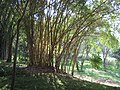 Karanji Lake
 -
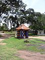
 CPM Office
 -
 Sosale temple
 -
 Bannur chariot
 -
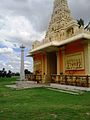
 Thandavapura temple
 -
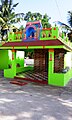
 Chinnadagudihundi temple
 -
 Kenchalagudu temple, Mananthavady Road
.jpg)


