"ഫിലഡെൽഫിയ" എന്ന താളിന്റെ പതിപ്പുകൾ തമ്മിലുള്ള വ്യത്യാസം
Jacob.jose (സംവാദം | സംഭാവനകൾ) No edit summary |
Jacob.jose (സംവാദം | സംഭാവനകൾ) No edit summary |
||
| വരി 1: | വരി 1: | ||
{{prettyurl|Philadelphia}} |
{{prettyurl|Philadelphia}} |
||
{{Infobox settlement |
{{Infobox settlement |
||
|name |
|name = ഫിലഡെൽഫിയ |
||
|official_name = സിറ്റി ഓഫ് ഫിലഡെൽഫിയ |
|||
|official_name = ഫിലഡെൽഫിയ നഗരം |
|||
|settlement_type = [[ |
|settlement_type = [[Consolidated city-county]] |
||
|image_skyline = Philadelhpia Montage by Jleon 0310.jpg |
|image_skyline = Philadelhpia Montage by Jleon 0310.jpg |
||
|imagesize = 325px |
|imagesize = 325px |
||
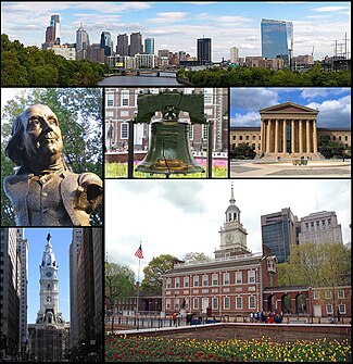
|image_caption = From top left, the Philadelphia skyline, a [[Girard Fountain Park|statue of Benjamin Franklin]], the [[Liberty Bell]], the [[Philadelphia Museum of Art]], [[Philadelphia City Hall]], and [[Independence Hall]] |
|image_caption = From top left, the Philadelphia skyline, a [[Girard Fountain Park|statue of Benjamin Franklin]], the [[Liberty Bell]], the [[Philadelphia Museum of Art]], [[Philadelphia City Hall]], and [[Independence Hall]] |
||
|nickname = "Philly", "City of Brotherly Love", "The City that Loves you Back", "Cradle of Liberty", "The Quaker City", "The Birthplace of America","The City of Neighborhoods" |
|nickname = "Philly", "City of Brotherly Love", "The City that Loves you Back", "Cradle of Liberty", "The Quaker City", "The Birthplace of America", "The City of Neighborhoods" |
||
|motto = "Philadelphia maneto" ("Let brotherly love endure") |
|motto = "Philadelphia maneto" ("Let brotherly love endure") |
||
|Founded by = William Penn |
|Founded by = William Penn |
||
|image_flag = Flag of Philadelphia, Pennsylvania.svg |
|image_flag = Flag of Philadelphia, Pennsylvania.svg |
||
|image_seal = Seal of Philadelphia, Pennsylvania.svg |
|image_seal = Seal of Philadelphia, Pennsylvania.svg |
||
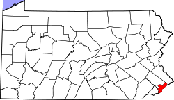
|image_map = Map of Pennsylvania highlighting Philadelphia County.svg |
|image_map = Map of Pennsylvania highlighting Philadelphia County.svg |
||
|pushpin_map = |
|pushpin_map = USA |
||
|pushpin_map_caption |
|pushpin_map_caption = അമേരിക്കൻ ഐക്യനാടുകളിൽ സ്ഥാനം |
||
|pushpin_label_position = left |
|pushpin_label_position = left |
||
|coordinates_region = US-PA |
|coordinates_region = US-PA |
||
|subdivision_type = |
|subdivision_type = [[List of sovereign states|രാജ്യം]] |
||
|subdivision_type2 = [[Political divisions of the United States| |
|subdivision_type2 = [[Political divisions of the United States|കോമൺവെൽത്ത്]] |
||
|subdivision_type4 = [[List of counties in Pennsylvania| |
|subdivision_type4 = [[List of counties in Pennsylvania|രാജ്യം]] |
||
|subdivision_name = [[അമേരിക്കൻ ഐക്യനാടുകൾ]] |
|subdivision_name = [[United States|അമേരിക്കൻ ഐക്യനാടുകൾ]] |
||
|subdivision_name2 = [[ |
|subdivision_name2 = [[Pennsylvania|പെൻസിൽവാനിയ]] |
||
|subdivision_name4 = [[Philadelphia County, Pennsylvania| |
|subdivision_name4 = [[Philadelphia County, Pennsylvania|ഫിലഡെൽഫിയ]] |
||
|subdivision_type1 |
|subdivision_type1 = |
||
|subdivision_name1 = |
|subdivision_name1 = |
||
|subdivision_type3 = [[Colony| |
|subdivision_type3 = [[Colony|പരമ്പരാഗത കോളനി]] |
||
|subdivision_name3 = [[ |
|subdivision_name3 = [[Province of Pennsylvania|ഫിലഡെൽഫിയ പ്രൊവിൻസ്]] |
||
| |
|government_type = [[Mayor–council government|മേയർ-കൗൺസിൽ]] |
||
|governing_body = [[Philadelphia City Council|ഫിലഡെൽഫിയ സിറ്റി കൗൺസിൽ]] |
|||
| ⚫ | |||
|leader_title = [[Mayor of Philadelphia|മേയർ]] |
|||
| ⚫ | |||
| ⚫ | |||
| ⚫ | |||
| ⚫ | |||
|established_date = October 27, 1682 |
|||
| ⚫ | |||
| ⚫ | |||
| |
|established_date = ഒക്ടോബർ 27, 1682 |
||
| ⚫ | |||
| ⚫ | |||
| |
|area_magnitude = 1 E8 |
||
| |
|unit_pref = Imperial |
||
| |
|area_total_sq_mi = 141.6 |
||
|area_land_sq_mi = 134.1<ref>Source U.S. Census Bureau: State and County QuickFacts. Data derived from Population Estimates, American Community Survey, Census of Population and Housing, State and County Housing Unit Estimates, County Business Patterns, Nonemployer Statistics, Economic Census, Survey of Business Owners, Building Permits.</ref> |
|||
|area_total_mi2 = 349.65 |
|||
| |
|area_land_km2 = 347.3 |
||
| |
|area_total_mi2 = 366.7 |
||
| |
|area_water_sq_mi = 7.5 |
||
| |
|area_water_km2 = 19.4 |
||
| |
|area_urban_sq_mi = 1799.5 |
||
| |
|area_urban_km2 = 4660.5 |
||
| |
|area_metro_sq_mi = 4629 |
||
| |
|area_metro_km2 = 11988.6 |
||
| |
|population_as_of = [[United States Census Bureau|2013]] |
||
|population_footnotes = <ref name="2013 Pop Estimate">{{cite web|title=Population Estimates|url=http://www.census.gov/popest/data/cities/totals/2013/SUB-EST2013-3.html|publisher=[[United States Census Bureau]]|accessdate=June 11, 2014}}</ref> |
|||
|population_metro = 5,965,343 |
|||
| |
|population_total = 1,553,165 |
||
|population_rank = US: [[List of United States cities by population|5th]] |
|||
| ⚫ | |||
|population_metro = 6,034,678 (US: [[List of Metropolitan Statistical Areas|6th]]) |
|||
| ⚫ | |||
|population_urban = 5,441,567 (US: [[List of United States urban areas|5th]]) |
|||
| ⚫ | |||
| ⚫ | |||
|population_blank1_title = [[Combined statistical area|CSA]] |
|population_blank1_title = [[Combined statistical area|CSA]] |
||
|population_blank1 = |
|population_blank1 = 7,146,706 (US: [[List of Combined Statistical Areas|8th]]) |
||
|population_blank2_title = [[Demonym]] |
|population_blank2_title = [[Demonym]] |
||
|population_blank2 = Philadelphian |
|population_blank2 = Philadelphian |
||
|timezone = [[North American Eastern Time Zone|EST]] |
|timezone = [[North American Eastern Time Zone|EST]] |
||
|utc_offset = -5 |
|utc_offset = -5 |
||
|timezone_DST = [[Eastern Daylight Time|EDT]] |
|timezone_DST = [[Eastern Daylight Time|EDT]] |
||
|utc_offset_DST = -4 |
|utc_offset_DST = -4 |
||
|postal_code_type = ZIP code |
|postal_code_type = ZIP code |
||
|postal_code = 191xx |
|postal_code = 191xx |
||
|area_code = [[Area code 215|215]], [[Area code 267|267]] |
|area_code = [[Area code 215|215]], [[Area code 267|267]] |
||
|latd=39 |latm=57 |
|latd=39 |latm=57 |latNS=N |
||
|longd=75 |longm=10 |
|longd=75 |longm=10 |longEW=W |
||
| |
|coordinates_display = inline, title |
||
| |
|elevation_m = 12 |
||
| |
|elevation_ft = 39 |
||
| |
|website = [http://www.phila.gov www.phila.gov] |
||
| ⚫ | |||
}} |
}} |
||
[[യു.എസ്.എ.|അമേരിക്കൻ ഐക്യനാടുകളിലെ]] [[പെൻസിൽവാനിയ|പെൻസിൽവേനിയ]] സംസ്ഥാനത്തെ ഏറ്റവും വലിയ നഗരമാണ് '''ഫിലഡെൽഫിയ'''. രാജ്യത്തെ ഏറ്റവും ജനവാസമുള്ള ആറാമത്തെ നഗരവുമാണിത്. അനൌദ്യോഗികമായി '''ഫിലി''' എന്ന ചുരുക്കപ്പേരിലും അറിയപ്പെടുന്ന ഫിലഡെൽഫിയയ്ക്ക് "സാഹോദര്യ സ്നേഹത്തിന്റെ നഗരം", "അമേരിക്കയുടെ ജന്മദേശം", "സ്വാതന്ത്ര്യത്തിന്റെ തൊട്ടിൽ" എന്നിങ്ങനെ അപരനാമങ്ങളുമുണ്ട്. രാജ്യത്തിന്റെ സാംസ്കാരിക, വിദ്യാഭ്യാസ, വാണിജ്യ മേഖലകളിൽ തന്ത്രപ്രധാനമായ സ്ഥാനമുണ്ട് ഈ നഗരത്തിന്. |
[[യു.എസ്.എ.|അമേരിക്കൻ ഐക്യനാടുകളിലെ]] [[പെൻസിൽവാനിയ|പെൻസിൽവേനിയ]] സംസ്ഥാനത്തെ ഏറ്റവും വലിയ നഗരമാണ് '''ഫിലഡെൽഫിയ'''. രാജ്യത്തെ ഏറ്റവും ജനവാസമുള്ള ആറാമത്തെ നഗരവുമാണിത്. അനൌദ്യോഗികമായി '''ഫിലി''' എന്ന ചുരുക്കപ്പേരിലും അറിയപ്പെടുന്ന ഫിലഡെൽഫിയയ്ക്ക് "സാഹോദര്യ സ്നേഹത്തിന്റെ നഗരം", "അമേരിക്കയുടെ ജന്മദേശം", "സ്വാതന്ത്ര്യത്തിന്റെ തൊട്ടിൽ" എന്നിങ്ങനെ അപരനാമങ്ങളുമുണ്ട്. രാജ്യത്തിന്റെ സാംസ്കാരിക, വിദ്യാഭ്യാസ, വാണിജ്യ മേഖലകളിൽ തന്ത്രപ്രധാനമായ സ്ഥാനമുണ്ട് ഈ നഗരത്തിന്. |
||
06:28, 5 സെപ്റ്റംബർ 2014-നു നിലവിലുണ്ടായിരുന്ന രൂപം
ഫിലഡെൽഫിയ | |||
|---|---|---|---|
| സിറ്റി ഓഫ് ഫിലഡെൽഫിയ | |||
 From top left, the Philadelphia skyline, a statue of Benjamin Franklin, the Liberty Bell, the Philadelphia Museum of Art, Philadelphia City Hall, and Independence Hall | |||
| |||
| Nickname(s): "Philly", "City of Brotherly Love", "The City that Loves you Back", "Cradle of Liberty", "The Quaker City", "The Birthplace of America", "The City of Neighborhoods" | |||
| Motto(s): "Philadelphia maneto" ("Let brotherly love endure") | |||
 | |||
| രാജ്യം | അമേരിക്കൻ ഐക്യനാടുകൾ | ||
| കോമൺവെൽത്ത് | പെൻസിൽവാനിയ | ||
| പരമ്പരാഗത കോളനി | ഫിലഡെൽഫിയ പ്രൊവിൻസ് | ||
| രാജ്യം | ഫിലഡെൽഫിയ | ||
| സ്ഥാപിതം | ഒക്ടോബർ 27, 1682 | ||
| ഇൻകോർപ്പറേറ്റഡ് | ഒക്ടോബർ 25, 1701 | ||
| • ഭരണസമിതി | ഫിലഡെൽഫിയ സിറ്റി കൗൺസിൽ | ||
| • മേയർ | Michael Nutter (D) | ||
| • Consolidated city-county | 141.6 ച മൈ (367 ച.കി.മീ.) | ||
| • ഭൂമി | 134.1[1] ച മൈ (347.3 ച.കി.മീ.) | ||
| • ജലം | 7.5 ച മൈ (19.4 ച.കി.മീ.) | ||
| • നഗരം | 1,799.5 ച മൈ (4,660.5 ച.കി.മീ.) | ||
| • മെട്രോ | 4,629 ച മൈ (11,988.6 ച.കി.മീ.) | ||
| ഉയരം | 39 അടി (12 മീ) | ||
| • Consolidated city-county | 1,553,165 | ||
| • റാങ്ക് | US: 5th | ||
| • ജനസാന്ദ്രത | 11,379.6/ച മൈ (4,393.8/ച.കി.മീ.) | ||
| • നഗരപ്രദേശം | 5,441,567 (US: 5th) | ||
| • മെട്രോപ്രദേശം | 6,034,678 (US: 6th) | ||
| • CSA | 7,146,706 (US: 8th) | ||
| • Demonym | Philadelphian | ||
| സമയമേഖല | UTC-5 (EST) | ||
| • Summer (DST) | UTC-4 (EDT) | ||
| ZIP code | 191xx | ||
| ഏരിയ കോഡ് | 215, 267 | ||
| വെബ്സൈറ്റ് | www.phila.gov | ||
അമേരിക്കൻ ഐക്യനാടുകളിലെ പെൻസിൽവേനിയ സംസ്ഥാനത്തെ ഏറ്റവും വലിയ നഗരമാണ് ഫിലഡെൽഫിയ. രാജ്യത്തെ ഏറ്റവും ജനവാസമുള്ള ആറാമത്തെ നഗരവുമാണിത്. അനൌദ്യോഗികമായി ഫിലി എന്ന ചുരുക്കപ്പേരിലും അറിയപ്പെടുന്ന ഫിലഡെൽഫിയയ്ക്ക് "സാഹോദര്യ സ്നേഹത്തിന്റെ നഗരം", "അമേരിക്കയുടെ ജന്മദേശം", "സ്വാതന്ത്ര്യത്തിന്റെ തൊട്ടിൽ" എന്നിങ്ങനെ അപരനാമങ്ങളുമുണ്ട്. രാജ്യത്തിന്റെ സാംസ്കാരിക, വിദ്യാഭ്യാസ, വാണിജ്യ മേഖലകളിൽ തന്ത്രപ്രധാനമായ സ്ഥാനമുണ്ട് ഈ നഗരത്തിന്.
അമേരിക്കയുടെ ആദ്യ തലസ്ഥാനമായ ഫിലഡെൽഫിയ ആയിരുന്നു പതിനെട്ടാം നൂറ്റാണ്ടിൽ രാജ്യത്തെ ഏറ്റവും ജനനിബിഡമായ നഗരം. സ്വാതന്ത്ര്യ സമരത്തിനുള്ള രാഷ്ട്രീയ നീക്കങ്ങളുടെ കേന്ദ്രം ഈ നഗരമായിരുന്നു. ബെഞ്ചമിൻ ഫ്രാങ്ക്ലിന്റെ പ്രവർത്തന കേന്ദ്രമെന്ന നിലയിൽ അക്കാലത്ത് ന്യൂയോർക്ക് സിറ്റി, ബോസ്റ്റൺ എന്നീ നഗരങ്ങളേക്കാൾ രാഷ്ട്രീയ പ്രാധാന്യവും ഫിൽഡെൽഫിയയ്ക്കുണ്ടായിരുന്നു.
ചരിത്രം
യൂറോപ്യന്മാരുടെ വരവിനുമുൻപ് ഫിലഡെൽഫിയയും സമീപ പ്രദേശങ്ങളും ലെനപീ ആദിവാസികളുടെ ആവാസകേന്ദ്രമായിരുന്നു. പതിനേഴാം നൂറ്റാണ്ടിന്റെ തുടക്കത്തിൽ ഡച്ച്, ബ്രിട്ടീഷ് സ്വീഡിഷ് സഞ്ചാരികൾ ഫിലഡെൽഫിയ ഉൾപ്പെടുന്ന ഡെലവെയർ നദീതടത്തിൽ വാസമുറപ്പിച്ചു. 1681-ൽ ബ്രിട്ടണിലെ ചാൾസ് രണ്ടാമൻ രാജാവ് ഈ പ്രദേശങ്ങളുടെ നിയന്ത്രണം വില്യം പെൻ എന്നയാൾക്കു നൽകി. പെൻസിൽവേനിയ എന്ന കോളനിയുടെ രൂപവത്കരണത്തിനു വഴിതെളിച്ചതും ഈ ഉടമ്പടിയാണ്. ഡെലവെയർ നദിയോടടുത്ത് വ്യാപാരത്തിന്റെയും ഭരണത്തിന്റെയും കേന്ദ്രമാകുംവിധത്തിൽ ഒരു നഗരം കെട്ടിപ്പടുക്കുക വില്യം പെന്നിന്റെ പദ്ധതിയായിരുന്നു. ചാൾസ് രണ്ടാമനിൽ നിന്നും ഭൂമിയുടെ അവകാശം ലഭിച്ചുവെങ്കിലും ലെനപീ ആദിവാസികളിൽ നിന്നും ഇദ്ദേഹം ഈ പ്രദേശം വീണ്ടും വാങ്ങി. ലെനപീ ആദിവാസികളുമായി സഹവർത്തിത്വത്തിൽ കഴിഞ്ഞ് തന്റെ കോളനിയിൽ സമാധാനം ഉറപ്പാക്കുകയായിരുന്നു പെന്നിന്റെ ലക്ഷ്യം. ക്വേക്കർ എന്ന ക്രിസ്തീയവിഭാഗത്തിൽ അംഗമായിരുന്ന പെൻ മുൻപ് മതപീഡനങ്ങൾക്കിരയായിട്ടുണ്ട്. ഇക്കാരണത്താൽ തന്റെ കോളനിയിൽ മതഭേദമില്ലാതെ ആർക്കും ആരാധന നടത്താനുള്ള സ്വാതന്ത്ര്യമുണ്ടായിരിക്കമെന്നും അദ്ദേഹത്തിനു നിഷ്കർഷയുണ്ടായിരുന്നത്രേ. ഇതുകൊണ്ടാവണം തന്റെ ഭരണകേന്ദ്രമായ നഗരത്തിന് അദ്ദേഹം സാഹോദര്യ സ്നേഹം എന്നർത്ഥം വരുന്ന ഫിലഡെൽഫിയ എന്ന പേരു നൽകിയത്.
പുറത്തേയ്ക്കുള്ള കണ്ണികൾ
- City of Philadelphia government
- Historic Philadelphia Photographs
- Greater Philadelphia GeoHistory Network – historical maps and atlases of Philadelphia
- philly.com – Local news
- Visitor Site for Greater Philadelphia
- Official Convention & Visitors Site for Philadelphia
39°57′N 75°10′W / 39.95°N 75.17°W
- ↑ Source U.S. Census Bureau: State and County QuickFacts. Data derived from Population Estimates, American Community Survey, Census of Population and Housing, State and County Housing Unit Estimates, County Business Patterns, Nonemployer Statistics, Economic Census, Survey of Business Owners, Building Permits.
- ↑ "Population Estimates". United States Census Bureau. Retrieved June 11, 2014.
- Pages using infobox settlement with possible area code list
- അമേരിക്കൻ ഐക്യനാടുകളുടെ ഭൂമിശാസ്ത്രം - അപൂർണ്ണലേഖനങ്ങൾ
- ഫിലഡെൽഫിയ (പെൻസിൽവാനിയ)
- പെൻസിൽവാനിയയിലെ നഗരങ്ങൾ
- 1682ൽ സ്ഥാപിതമായ ജനവാസപ്രദേശങ്ങൾ
- അമേരിക്കൻ ഐക്യനാടുകളുടെ മുൻ തലസ്ഥാനങ്ങൾ
- അമേരിക്കൻ ഐക്യനാടുകളിലെ മുൻ സംസ്ഥാന തലസ്ഥാനങ്ങൾ
- അമേരിക്കൻ ഐക്യനാടുകളുടെ അറ്റ്ലാന്റിക്ക് തീരത്തെ തുറമുഖ നഗരങ്ങളും പട്ടണങ്ങളും
- അമേരിക്കൻ ഐക്യനാടുകളിലെ ആസൂത്രിത നഗരങ്ങൾ
- പെൻസിൽവാനിയയിലെ കൗണ്ടി ആസ്ഥാനങ്ങൾ
- അമേരിക്കയിലെ വൻനഗരങ്ങൾ


