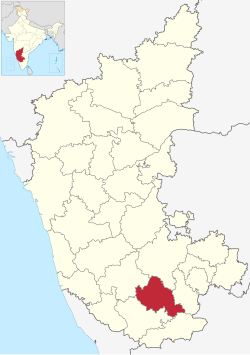
മാണ്ഡ്യ ജില്ല
(Mandya district എന്ന താളിൽ നിന്നും തിരിച്ചുവിട്ടതു പ്രകാരം)
മാണ്ഡ്യ ജില്ല ಮಂಡ್ಯ ಜಿಲ್ಲೆ Sakkare Nadu | |
|---|---|
district | |
 | |
 Location in Karnataka, India | |
| Country | |
| State | കർണാടക |
| Region | Bayaluseeme |
| Division | Mysore Division |
| Established | 1 July 1939[1] |
| Headquarters | Mandya |
| Talukas | Mandya, Malavalli, Maddur, Nagamangala, Krishnarajpet, Pandavapura, Srirangapatna |
| • Deputy Commissioner | B N Krishnaiah IAS |
| • ആകെ | 4,961 ച.കി.മീ.(1,915 ച മൈ) |
(2011)[3] | |
| • ആകെ | 1,805,769 |
| • ജനസാന്ദ്രത | 360/ച.കി.മീ.(940/ച മൈ) |
| • Official | Kannada |
| സമയമേഖല | UTC+5:30 (IST) |
| ISO കോഡ് | IN-KA-MA |
| വാഹന റെജിസ്ട്രേഷൻ | KA-11,KA-54 |
| Sex ratio | 1.015 ♂/♀ |
| Literacy | 61.21% |
| Lok Sabha constituency | Mandya Lok Sabha constituency |
| Climate | Tropical Semi-arid (Köppen) |
| Precipitation | 691 millimetres (27.2 in) |
| Avg. summer temperature | 35 °C (95 °F) |
| Avg. winter temperature | 16 °C (61 °F) |
| വെബ്സൈറ്റ് | mandya |
ഇന്ത്യൻ സംസ്ഥാനമായ കർണാടകത്തിലെ ഒരു ജില്ലയാണ് മാണ്ഡ്യ 1939-ൽ രൂപീകൃതമായ മാണ്ഡ്യ ജില്ലയിലെ പ്രധാന പട്ടണം മാണ്ഡ്യ ആണ്. 2011-ജില്ലാ ജനസംഖ്യ 18,08,680 ആയിരുന്നു[4]
ഭൂമിശാസ്ത്രം[തിരുത്തുക]
തെക്ക് മൈസൂർ ജില്ല, പടിഞ്ഞാറ് ഹാസൻ ജില്ല, വടക്ക് തുംകൂർ ജില്ല, കിഴക്ക് രാംനഗർ ജില്ല എന്നിവയാണ് അതിർത്തികൾ.
അവലംബം[തിരുത്തുക]
- ↑ "District Profile". Department of State Education Research and Training. Retrieved 6 January 2011.
- ↑ "Know India - Karnataka". Government of India. Retrieved 6 January 2011.
- ↑ "District Statistics". Official Website of Mandya district. Archived from the original on 2011-07-21. Retrieved 6 January 2011.
- ↑ "India Census Map". Archived from the original on 2015-04-25. Retrieved 2015-04-01.
