സാൻ ഹസീന്തോ കൊടുമുടി
| സാൻ ഹസീന്തോ കൊടുമുടി | |
|---|---|
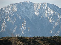
 North face | |
| ഉയരം കൂടിയ പർവതം | |
| Elevation | 10,834 അടി (3,302 മീ) NAVD 88[2] |
| Prominence | 8,319 അടി (2,536 മീ) ↓ സാൻ ഗൊർഗോനിയോ പാസ് [3] |
| Isolation | 20.3 മൈ (32.7 കി.മീ) → Bighorn Mountain |
| Listing | |
| Coordinates | 33°48′53″N 116°40′46″W / 33.814712342°N 116.679438022°W [2] |
| മറ്റ് പേരുകൾ | |
| English translation | വിശുദ്ധ ഹയാസിന്തിന്റെ കൊടുമുടി |
| Language of name | സ്പാനിഷ് |
| ഭൂമിശാസ്ത്രപരമായ പ്രത്യേകതകൾ | |
| സ്ഥാനം | Riverside County, California, U.S. |
| Parent range | San Jacinto Mountains |
| Topo map | USGS San Jacinto Peak |
| Climbing | |
| First ascent | 1874 by "F. of Riverside" |
| Easiest route | Tramway trail hike |
അമേരിക്കൻ ഐക്യനാടുകളിലെ കാലിഫോർണിയ സംസ്ഥാനത്തെ, റിവർസൈഡ് കൗണ്ടിയിലെ സാൻ ഹസീന്തോ മലനിരകളിൽ സ്ഥിതിചെയ്യുന്ന ഉയരം കൂടിയ കൊടുമുടിയാണ് സാൻ ഹസീന്തോ കൊടുമുടി. ഈ കൊടുമുടിയിൽ മൗണ്ട് സാൻ ഹസീന്തോ സ്റ്റേറ്റ് പാർക്ക് സ്ഥിതിചെയ്യുന്നു. പ്രകൃതിസ്നേഹിയായ ജോൺ മ്യൂർ സാൻ ഹസീന്തോ കൊടുമുടിയെക്കുറിച്ച് ഇങ്ങനെ എഴുതുകയുണ്ടായി, സാൻ ഹസീന്തോയിൽ നിന്നുള്ള ദൃശ്യം ഭൂമിയിൽ മറ്റൊരിടത്തും കാണാൻ കഴിയാത്ത ആകർഷണീയമായ കാഴ്ചയാണ്. [4]
സാൻ ഹസീന്തോ കൊടുമുടി അമേരിക്കൻ ഐക്യനാടുകളിലെ പ്രമുഖ കൊടുമുടികളിലൊന്നാണ്. തൊട്ടടുത്ത 48 സ്റ്റേറ്റുകളിൽ ആറാംസ്ഥാനത്ത് നിൽക്കുന്ന കൊടുമുടി കൂടിയാണിത്.[5] സാൻ ഹസീന്തോ ലേഖകരായ ജോൺ ഡബ്ള്യൂ. റോബിൻസന്റെയും ബ്രൂസ് ഡി. റിഷറിന്റെയും വീക്ഷണത്തിൽ സാൻ ഹസീന്തോ കൊടുമുടി കയറാത്ത ഒരൊറ്റ കാൽനടയാത്രക്കാർ പോലും തെക്കൻ കാലിഫോർണിയയിലുണ്ടാവില്ല.[6] കാക്റ്റസ് റ്റു ട്രെയിലിലേയ്ക്ക് ധാരാളം കാൽനടക്കാർ ഇവിടത്തെ ആകർഷണീയമായ കാഴ്ച കേട്ടറിഞ്ഞ് കൂട്ടമായി 10,000 അടി മുകളിലുള്ള സാൻ ഗോർഗോനിയോപാസ്സിൽ എത്താറുണ്ട്.
ചിത്രശാല
[തിരുത്തുക]-
സാൻ ഹസീന്തോ കൊടുമുടി
-
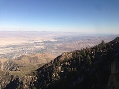
പാം സ്പ്രിംഗ്സിലെ പർവ്വതസ്റ്റേഷനിൽ നിന്ന്
-
Emergency hut near the summit
-
Near the summit of San Jacinto
അവലംബം
[തിരുത്തുക]- ↑ "San Jacinto Peak". Hundred Peaks Section List. Angeles Chapter, Sierra Club. Retrieved 2009-08-17.
- ↑ 2.0 2.1 "San Jacinto". NGS data sheet. U.S. National Geodetic Survey. Retrieved 2008-11-02.
- ↑ "San Jacinto Peak, California". Peakbagger.com. Retrieved 2012-04-01.
- ↑ Heald, Weldon F. (July, 1963) "The Lordly San Jacintos," in Westways. The account of Muir visiting Mt. San Jacinto appeared first in Frederick, K. P. (1926) Legends and History of the San Jacinto Mountains. Long Beach, CA.
- ↑ USA Lower 48 Top 100 Peaks by Prominence". Peakbagger.com. Retrieved 2012-04-01.
- ↑ Robinson, John W; Bruce D. Risher (1993). The San Jacintos. Arcadia: Big Santa Anita Historical Society. p. 195. ISBN 0-9615421-6-0.
പുറത്തേയ്ക്കുള്ള കണ്ണികൾ
[തിരുത്തുക]- "Mount San Jacinto State Park". California State Parks. Retrieved 2009-08-17.
- Mount San Jacinto State Park map (PDF) (Map). Mount San Jacinto State Park. Archived from the original (PDF) on 2016-03-05. Retrieved 2015-11-24.
- "San Jacinto Peak". SummitPost.org. Retrieved 2011-05-07.
- "Cactus to Clouds Hiking Guide". Mt. San Jacinto Message Board. Archived from the original on 2009-10-25. Retrieved 2009-08-17.
- "Main page". Riverside Mountain Rescue Unit. Retrieved 2009-08-17.
- "Forum Index". Mt. San Jacinto Outdoor Recreation. Retrieved 2009-08-17.
- Howser, Huell (January 8, 1997). "Mt. San Jacinto – California's Gold (804)". California's Gold. Chapman University Huell Howser Archive.


