ഹവായി ദ്വീപുകൾ
| Geography | |
|---|---|
| Location | North Pacific Ocean |
| Administration | |
United States | |
| Demographics | |
| Population | 1,450,000 |
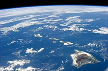
ഹവായി ദ്വീപുകൾ (Hawaiian: Mokupuni o Hawai‘i) 1500 മൈലുകൾ (2400 കി. മി.) നീളത്തിൽ ഉത്തര പസഫിക്കിൽ തെക്ക് ഹവായ് ദ്വീപിനും വടക്കൻ അറ്റത്തുള്ള കുറി അറ്റോളിനും ഇടയിൽക്കിടക്കുന്ന 8 പ്രധാന ദ്വീപുകളുടെയും അനേകം അറ്റോളുകളുടെയും ദ്വീപശകലങ്ങളുടെയും കടലിനടിയിലെ കടൽക്കുന്നുകളുടെയും കൂട്ടമാണിത്. സാന്റ്വിച്ച് ദ്വീപുകൾ എന്നാണ് യൂറോപ്യന്മാരും അമേരിക്കക്കാരും ഇവയെ വിളിച്ചത്. സാന്റ്വിച്ച് എന്ന പേര് സാന്റ്വിച്ചിലെ നാലാം ഏൾ ആയ ജോൺ മൊണ്ടാഗുവുമായി ബന്ധപ്പെട്ടാണ് സാഹസികസഞ്ചാരിയായ ജെയിംസ് കുക്ക് ഇവയ്ക്ക് ഈ പേരു നിർദ്ദേശിച്ചത്. ഇപ്പോൾ ഉപയോഗിക്കുന്ന പേര് ഹവായി പ്രധാന കരയിൽനിന്നും ഉൽഭവിച്ചു.
1893ൽ ഹവായിയിലെ രാജാവിനെ രാജാധികാരത്തിൽനിന്നും സ്ഥാനഭ്രഷ്ടനാക്കിയശേഷം അമേരിക്ക ഈ ദ്വീപുകളെ യുണൈറ്റെഡ് സ്റ്റേറ്റ്സുമായി ചേർത്തു. [1]ഇന്ന് ഹവായിയുടെ പ്രധാന ദ്വീപുകളും മനുഷ്യവാസമില്ലാത്ത ഉത്തര ദ്വീപുകളിൽ മിക്കവയും ചേർത്താണ് യുനൈറ്റഡ് സ്റ്റേറ്റ്സിലെ ഒരു സ്റ്റേറ്റായി ചേർത്തത്.
ഹവായിയൻ എമ്പറർ സീമൗൻട് ശൃംഖല എന്ന അഗ്നിപർവ്വതപ്രവർത്തനം മൂലം സമുദ്രാന്തർഭാഗത്തുണ്ടായ പർവ്വതനിരയുടെ ജലത്തിനുമുകളിലുള്ള ഭാഗമാണ് ഇക്കാണുന്ന ഹവായി ദ്വീപുകൾ. ഏറ്റവും അടുത്തുള്ള ഭുഖണ്ഡത്തിൽനിന്നും 3000 കിലോമീറ്ററോളം അകലെയാണ് ഈ ദ്വീപസമൂഹം കിടക്കുന്നത്.
ദ്വീപുകളും പവിഴപുറ്റുകളും
[തിരുത്തുക]
1778 ജനുവരി 18 നാണ് മ്യാപ്റ്റൻ ജെയിംസ് കുക്ക് ദ്വീപുകൾ സന്ദർശിച്ച് സാന്റ്വിച്ച് ദ്വീപുകൾ എന്നു വിളിച്ചത്. സാന്റ്വിച്ച് എന്ന പേര് സാന്റ്വിച്ചിലെ നാലാം ഏൾ ആയ ജോൺ മൊണ്ടാഗുവിന്റെ സ്മരണാർത്ഥമാണ് നൽകിയത്. പ്രാദേശികമായ പേരായ ഹവായി ഉപയോഗിച്ചുതുടങ്ങുന്നതിനുമുൻപ്1840 വരെ ഈ പേരായിരുന്നു ഉപയോഗിച്ചിരുന്നത്. ഹവായി ദ്വീപുകൽക്കു മൊത്തത്തിൽ 6,423.4 square miles (16,636.5 km2) വിസ്തീർണ്ണമുണ്ട്. ഈ ദ്വീപുകളും അവയ്ക്കിടയിലുള്ള ദ്വിപുസമാനപ്രദേശങ്ങളും യുണൈറ്റെഡ് സ്റ്റേറ്റ്സിന്റെ 50ആം സംസ്ഥാനമായാണ് (ഹവായി സംസ്ഥാനം) ഭരണനിർവ്വഹണം നടത്തുന്നത്.
പ്രധാന ദ്വീപുകൾ
[തിരുത്തുക]Main islands
[തിരുത്തുക]The eight main islands of Hawaii (also called the Hawaiian Windward Islands) are listed here. All except Kahoʻolawe are inhabited.[അവലംബം ആവശ്യമാണ്]
| Island | Nickname | Area | Population (as of 2010) |
Density | Highest point | Elevation | Age (Ma)[3] | Location |
|---|---|---|---|---|---|---|---|---|
| Hawaiʻi[4] | The Big Island | 4,028.0 sq mi (10,432.5 km2) | 185,079 | 45.948/sq mi (17.7407/km2) | Mauna Kea | 13,796 ft (4,205 m) | 0.4 | 19°34′N 155°30′W / 19.567°N 155.500°W |
| Maui[5] | The Valley Isle | 727.2 sq mi (1,883.4 km2) | 144,444 | 198.630/sq mi (76.692/km2) | Haleakalā | 10,023 ft (3,055 m) | 1.3–0.8 | 20°48′N 156°20′W / 20.800°N 156.333°W |
| Oʻahu[6] | The Gathering Place | 596.7 sq mi (1,545.4 km2) | 953,207 | 1,597.46/sq mi (616.78/km2) | Mount Kaʻala | 4,003 ft (1,220 m) | 3.7–2.6 | 21°28′N 157°59′W / 21.467°N 157.983°W |
| Kauaʻi[7] | The Garden Isle | 552.3 sq mi (1,430.5 km2) | 66,921 | 121.168/sq mi (46.783/km2) | Kawaikini | 5,243 ft (1,598 m) | 5.1 | 22°05′N 159°30′W / 22.083°N 159.500°W |
| Molokaʻi[8] | The Friendly Isle | 260.0 sq mi (673.4 km2) | 7,345 | 28.250/sq mi (10.9074/km2) | Kamakou | 4,961 ft (1,512 m) | 1.9–1.8 | 21°08′N 157°02′W / 21.133°N 157.033°W |
| Lānaʻi[9] | The Pineapple Isle | 140.5 sq mi (363.9 km2) | 3,135 | 22.313/sq mi (8.615/km2) | Lānaʻihale | 3,366 ft (1,026 m) | 1.3 | 20°50′N 156°56′W / 20.833°N 156.933°W |
| Niʻihau[10] | The Forbidden Isle | 69.5 sq mi (180.0 km2) | 170 | 2.45/sq mi (0.944/km2) | Mount Pānīʻau | 1,250 ft (381 m) | 4.9 | 21°54′N 160°10′W / 21.900°N 160.167°W |
| Kahoʻolawe[11] | The Target Isle | 44.6 sq mi (115.5 km2) | 0 | 0 | Puʻu Moaulanui | 1,483 ft (452 m) | 1.0 | 20°33′N 156°36′W / 20.550°N 156.600°W |
ചെറിയ ദ്വീപുകൾ, അറ്റോളുകൾ, റീഫുകൾ
[തിരുത്തുക]Smaller islands, atolls, and reefs (all west of Niʻihau are uninhabited) form the Northwestern Hawaiian Islands, or Hawaiian Leeward Islands:
- Nihoa (Mokumana)
- Necker (Mokumanamana)
- French Frigate Shoals (Kānemilohaʻi)
- Gardner Pinnacles (Pūhāhonu)
- Maro Reef (Nalukākala)
- Laysan (Kauō)
- Lisianski Island (Papaʻāpoho)
- Pearl and Hermes Atoll (Holoikauaua)
- Midway Atoll (Pihemanu)
- Kure Atoll (Mokupāpapa)
See also
[തിരുത്തുക]- Hawaii
- Outline of Hawaii
- Index of Hawaii-related articles
- List of Hawaii birds
- List of fish of Hawaii
- List of Ultras of Hawaii
- Maritime Fur Trade
- Mountain peaks of Hawaii
- Hawaii Inter-Island Cable System
References
[തിരുത്തുക]- ↑ Kent, Noel J. (1993). Hawaii: Islands Under the Influence. University of Hawaii Press. pp. x. ISBN 0-8248-1552-1.
- ↑ "Hawaii : Image of the Day". nasa.gov. Retrieved 4 June 2015.
- ↑ Blay, Chuck, and Siemers, Robert. Kauai‘’s Geologic History: A Simplified Guide. Kaua‘i: TEOK Investigations, 2004. ISBN 9780974472300. (Cited in "Hawaiian Encyclopedia : The Islands". Retrieved June 20, 2012.)
- ↑ U.S. Geological Survey Geographic Names Information System: Island of Hawaiʻi
- ↑ U.S. Geological Survey Geographic Names Information System: Maui Island
- ↑ U.S. Geological Survey Geographic Names Information System: Oʻahu Island
- ↑ U.S. Geological Survey Geographic Names Information System: Kauaʻi Island
- ↑ U.S. Geological Survey Geographic Names Information System: Molokaʻi Island
- ↑ U.S. Geological Survey Geographic Names Information System: Lānaʻi Island
- ↑ U.S. Geological Survey Geographic Names Information System: Niʻihau Island
- ↑ U.S. Geological Survey Geographic Names Information System: Kahoʻolawe Island
Further reading
[തിരുത്തുക]- Morgan, Joseph R. (1996). "Hawai'i: A Unique Geography". Honolulu, HI: Bess Press. ISBN 1-57306-021-6.
{{cite journal}}:|contribution=ignored (help); Cite journal requires|journal=(help) - An integrated information website focused on the Hawaiian Archipelago from the Pacific Region Integrated Data Enterprise (PRIDE).
- Macdonald, G. A., A. T. Abbott, and F. L. Peterson. 1984. Volcanoes in the Sea: The Geology of Hawaii, 2nd edition. University of Hawaii Press, Honolulu. 517 pp.
- The Ocean Atlas of Hawai‘i Archived 2022-04-07 at the Wayback Machine. - SOEST at University of Hawaiʻi.
- "Hawaiian Volcanoes - Introduction". Volcano World | Your World is Erupting. Corvallis, OR, USA: Department of Geosciences, Oregon State University College of Science. Archived from the original on 2012-03-05. Retrieved May 12, 2012.
{{cite web}}: External link in|publisher=and|work=

