വെഞ്ചുറ, കാലിഫോർണിയ
വെഞ്ചുറ | ||
|---|---|---|
| City of San Buenaventura | ||
 Ventura, California, viewed from the southwest | ||
| ||
| Nickname(s): "Ventura" | ||
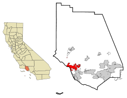
 Location in Ventura County | ||
| Coordinates: 34°16′30″N 119°13′40″W / 34.27500°N 119.22778°W | ||
| Country | United States | |
| State | California | |
| County | Ventura | |
| Mission | March 31, 1782 | |
| Incorporated | April 2, 1866[1] | |
| നാമഹേതു | Saint Bonaventure | |
| • Mayor | Neal Andrews[2] | |
| • City manager | Mark Watkins[3] | |
| • CA Senate | Hannah-Beth Jackson (D)[4] | |
| • CA Assembly | Monique Limón (D)[4] | |
| • U.S. Congress[5] | CA-24: Salud Carbajal (D) CA-26: Julia Brownley (D) | |
| • ആകെ | 32.25 ച മൈ (83.53 ച.കി.മീ.) | |
| • ഭൂമി | 21.82 ച മൈ (56.50 ച.കി.മീ.) | |
| • ജലം | 10.43 ച മൈ (27.03 ച.കി.മീ.) 32.53% | |
| ഉയരം | 36 അടി (11 മീ) | |
| • ആകെ | 1,06,433 | |
| • കണക്ക് ({{{pop_est_as_of}}})[9] | 1,09,592 | |
| • റാങ്ക് | 4th in Ventura County 58th in California | |
| • ജനസാന്ദ്രത | 5,023.70/ച മൈ (1,939.67/ച.കി.മീ.) | |
| Demonym(s) | Venturan | |
| സമയമേഖല | UTC−8 (Pacific) | |
| • Summer (DST) | UTC−7 (PDT) | |
| ZIP codes[10] | 93001–93007, 93009 | |
| ഏരിയ കോഡ് | 805 | |
| FIPS code | 06-65042 | |
| GNIS feature IDs | 1667934, 2411779 | |
| വെബ്സൈറ്റ് | cityofventura | |
വെഞ്ചുറ, അമേരിക്കൻ ഐക്യനാടുകളിലെ സംസ്ഥാനമായ കാലിഫോർണിയയിൽ, വെഞ്ചുറ കൗണ്ടിയുടെ കൌണ്ടിസീറ്റായ നഗരമാണ്. ഈ നഗരം ഔദ്യോഗികമായി സാൻ ബ്യൂണാവെഞ്ചുറ എന്നറിയപ്പെടുന്നു.[11] യൂറോപ്പ്യൻ പര്യവേക്ഷകർ പസിഫിക് തീരത്തുകൂടി സഞ്ചരിക്കുമ്പോൾ വെഞ്ചുറയിൽ ഷിഷോലോപ് എന്നു വിശേഷിപ്പിക്കപ്പെട്ട ഒരു ചുമാഷ് ഗ്രാമവുമായി ആകസ്മികമായി സന്ധിച്ചിരുന്നു.[12][13](p36) 1782 ൽ മിഷൻ സാൻ ബ്യൂണാവെഞ്ചുറ സമീപപ്രദേശത്തു സ്ഥാപിക്കപ്പെടുകയും വെഞ്ചുറ നദിയിലെ ജലം മിഷൻറെ ദൈനംദിന പ്രവർത്തനങ്ങൾക്ക് ഉപയോഗപ്പെടുത്തുകയും ചെയ്തിരുന്നു. മിഷൻ സംവിധാനത്തിനു ചുറ്റുമായി നഗരം വളർന്നു വികസിക്കുകയും 1866 ൽ ഇതു സംയോജിപ്പിക്കപ്പെടുകയും ചെയ്തു. 1920 കളിൽ സമീപപ്രദേശങ്ങളിലെ എണ്ണപ്പാടങ്ങളുടെ വികസനവും ഓട്ടോമോബൈൽ സഞ്ചാര സൌകര്യങ്ങളുംറിയൽ എസ്റ്റേറ്റ് രംഗത്ത് ഒരു വലിയ കുതിച്ചുകയറ്റത്തിനു കാരണമായിത്തീർന്നു. ഇക്കാലത്ത് നിരവധി അതിരടയാളങ്ങളായി കണക്കാക്കപ്പെട്ട സൗധങ്ങളുടെ നിർമ്മാണം നടന്നിരുന്നു. മതപ്രവർത്തക സംഘവും ചുറ്റുപാടുമുള്ള കെട്ടിടങ്ങളും, സാംസ്കാരിക, ലഘുവ്യാപാര, താമസകേന്ദ്രങ്ങളോടെ നഗരകേന്ദ്രത്തിൻറെ ഭാഗവും സന്ദർശകരുടെ ലക്ഷ്യസ്ഥാനമായി മാറുകയും ചെയ്തു.
ലോസ് ആഞ്ചലസിനും സാന്താ ബാർബറയ്ക്കുമിടയിലുള്ള ഒരു യഥാർത്ഥ യുഎസ് യാത്രാ മാർഗ്ഗമായ യു.എസ്. 101 പാതയിലാണ് വെഞ്ചുറ നഗരം സ്ഥിതിചെയ്യുന്നത്. ഇപ്പോൾ ഈ അതിവേഗപാത വെഞ്ചുറ ഫ്രീവേ എന്നറിയപ്പെടുന്നുണ്ടെങ്കിലും നഗരത്തിലെ പ്രധാന പാതയ്ക്കു സമാന്തരമായി കടന്നുപോകുന്ന യഥാർത്ഥ യാത്രാമാർഗ്ഗം എൽ കാമിനോ റീയൽ എന്ന പേരിൽ നിർദ്ദേശിക്കപ്പെട്ടിരിക്കുന്നതും 1769 നും 1833 നും ഇടയിലായി രൂപീകരിക്കപ്പെട്ട കാലിഫോർണിയ മിഷനുകൾ എന്നറിയപ്പെടുന്ന 21 സ്പാനിഷ് മതപ്രവർത്തക ദൗത്യ സംഘ പരമ്പരകളെ തമ്മിൽ ബന്ധിപ്പിക്കുന്നതുമാണ്.
രണ്ടാം ലോകയുദ്ധാനന്തര കാലഘട്ടത്തിൽ സാമ്പത്തിക വികസനത്തിൽ ഈ സമൂഹം കിഴക്കൻ പ്രദേശങ്ങളിലേയ്ക്ക് വളർന്നു വികസിക്കുകയും ഓക്സനാട് സമതലത്തിന്റെ അറ്റത്തു സാന്ത ക്ലാര നദിയാൽ സൃഷ്ടിക്കപ്പെട്ട സമ്പന്നമായ കൃഷിഭൂമിയിൽ നിരനിരയായി കുടുംബങ്ങളുടെ വാസത്തിനു യോഗ്യമായ വീടുകൾ നിർമ്മിക്കപ്പെടുകയും ചെയ്തു. 2000 ലെ സെൻസസിൽ 100,916 ആയിരുന്ന ഈ നഗരത്തിലെ ജനസംഖ്യ, 2010 ലെ സെൻസസിൽ 106,433 ആയി ഉയർന്നിരുന്നു.[14]
ചരിത്രം[തിരുത്തുക]
10,000 മുതൽ 12000 വർഷത്തോളമായി ഈ പ്രദേശത്ത് ജനവാസമുണ്ടായിരുന്നുവെന്നാണ് പുരാവസ്തു പഠനങ്ങൾ വ്യക്തമാക്കുന്നത്.[15] പുരാവസ്തു ഗവേഷണങ്ങളുടെ ഫലമായി ലഭിച്ച അവരുടെ സംസ്കാരത്തിൽ നിന്നും ഉരുത്തിരിഞ്ഞ കരകൌശലവസ്തുക്കളിൽനിന്ന് വെളിവാക്കപ്പെടുന്നത്, ചുമാഷ് വർഗ്ഗക്കാർക്ക് കാലിഫോർണിയയുടെ മദ്ധ്യ, തെക്കൻ തീരപ്രദേശങ്ങളുമായി വളരെ ആഴത്തിലുള്ള വേരുകളുണ്ടായിരുന്നുവെന്നാണ്.[16](p11)
അവലംബം[തിരുത്തുക]
- ↑ "California Cities by Incorporation Date". California Association of Local Agency Formation Commissions. Archived from the original (Word) on നവംബർ 3, 2014. Retrieved ഓഗസ്റ്റ് 25, 2014.
- ↑ "City Council". City of Ventura. Retrieved December 7, 2017.
- ↑ "City Manager Mark Watkins". City of Ventura. Archived from the original on 2019-01-06. Retrieved January 11, 2015.
- ↑ 4.0 4.1 "Statewide Database". UC Regents. Retrieved November 23, 2014.
- ↑ "Communities of Interest - City". California Citizens Redistricting Commission. Archived from the original on 2013-09-30. Retrieved September 27, 2014.
- ↑ "2016 U.S. Gazetteer Files". United States Census Bureau. Retrieved June 28, 2017.
- ↑ "Ventura". Geographic Names Information System. United States Geological Survey. Retrieved December 3, 2014.
- ↑ "E-1 Current Population Estimates for Cities, Counties, and the State: January 1, 2013 and 2014". State of California, Department of Finance. May 2014. Retrieved May 5, 2017.
- ↑ ഉദ്ധരിച്ചതിൽ പിഴവ്: അസാധുവായ
<ref>ടാഗ്;USCensusEst2016എന്ന പേരിലെ അവലംബങ്ങൾക്ക് എഴുത്തൊന്നും നൽകിയിട്ടില്ല. - ↑ "ZIP Code(tm) Lookup". United States Postal Service. Retrieved December 3, 2014.
- ↑ Erwin G. Gudde, California Place Names: The Origin and Etymology of Current Geographical Names, 4th ed., rev. and enlarged by William Bright (University of California Press, 1998), p. 410.
- ↑ Landmark #18: Shisholop Village Site Archived 2014-12-08 at the Wayback Machine. accessed October 7, 2013 from link on City Map with Historic Landmarks Archived 2013-10-02 at the Wayback Machine.
- ↑ McCall, Lynne; Perry, Rosalind (2002). California's Chumash Indians : a project of the Santa Barbara Museum of Natural History Education Center (Revised ed.). San Luis Obispo, Calif: EZ Nature Books. ISBN 0936784156.
- ↑ "San Buenaventura (Ventura), CA". Data USA. Retrieved November 29, 2017.
- ↑ Clerici, Kevin (July 17, 2007). "Artifacts are found at site". Ventura County Star. Archived from the original on December 3, 2013.
- ↑ McCall, Lynne; Perry, Rosalind (2002). California's Chumash Indians : a project of the Santa Barbara Museum of Natural History Education Center (Revised ed.). San Luis Obispo, Calif: EZ Nature Books. ISBN 0936784156.


