ബെനീസിയ
സിറ്റി ഓഫ് ബെനീസിയ | |
|---|---|
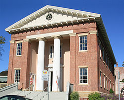
 California's third capitol at Benicia. The Senate chambers on first floor, and the Assembly chambers above | |
| Motto(s): "It's better in Benicia!" | |
 Location in Solano County and the state of California | |
| Coordinates: 38°3′48″N 122°9′22″W / 38.06333°N 122.15611°W | |
| Country | |
| State | |
| County | Solano |
| Incorporated | March 27, 1850[1] |
| • Mayor | Elizabeth Patterson[2] |
| • State senator | Bill Dodd (D)[3] |
| • Assemblymember | Tim Grayson (D)[3] |
| • U. S. rep. | Mike Thompson (D)[4] |
| • ആകെ | 15.720 ച മൈ (40.714 ച.കി.മീ.) |
| • ഭൂമി | 12.929 ച മൈ (33.486 ച.കി.മീ.) |
| • ജലം | 2.791 ച മൈ (7.229 ച.കി.മീ.) 17.75% |
| ഉയരം | 26 അടി (8 മീ) |
| • ആകെ | 26,997 |
| • കണക്ക് (2013)[7] | 27,618 |
| • ജനസാന്ദ്രത | 1,700/ച മൈ (660/ച.കി.മീ.) |
| സമയമേഖല | UTC−8 (Pacific) |
| • Summer (DST) | UTC−7 (PDT) |
| ZIP code | 94510 |
| Area code | 707 |
| FIPS code | 06-05290 |
| GNIS feature IDs | 0277472, 2409833 |
| വെബ്സൈറ്റ് | www |
ബെനീസിയ (/bəˈniːʃə/ bə-NEE-shə; സ്പാനിഷ് ഉച്ചാരണം: [beˈnisja]), അമേരിക്കൻ ഐക്യനാടുകളിൽ, സാൻ ഫ്രാൻസിസ്കോ ബേ ഏരിയയിലെ നോർത്ത് ബേ മേഖലയിൽ സ്ഥിതി ചെയ്യുന്ന, കാലിഫോർണിയ സംസ്ഥാനത്തെ സോളാനോ കൗണ്ടിയിലെ നഗരമാണ്. 1853 മുതൽ 1854 വരെയുള്ള കാലഘട്ടത്തിൽ ഏതാണ്ട് പതിമൂന്നു മാസക്കാലം ഈ നഗരം സംസ്ഥാന തലസ്ഥാനമായി പ്രവർത്തിച്ചിരുന്നു.
അവലംബം[തിരുത്തുക]
- ↑ "California Cities by Incorporation Date". California Association of Local Agency Formation Commissions. Archived from the original (Word) on November 3, 2014. Retrieved August 25, 2014.
- ↑ "City Council". City of Benicia. Retrieved September 20, 2014.
- ↑ 3.0 3.1 "Statewide Database". UC Regents. Retrieved December 5, 2014.
- ↑ "California's 5-ആം Congressional District - Representatives & District Map". Civic Impulse, LLC.
- ↑ "2010 Census U.S. Gazetteer Files – Places – California". United States Census Bureau.
- ↑ "Benicia". Geographic Names Information System. United States Geological Survey. Retrieved October 20, 2014.
- ↑ 7.0 7.1 "Benicia (city) QuickFacts". United States Census Bureau. Archived from the original on 2015-03-23. Retrieved March 15, 2015.

