ഡാലി സിറ്റി
ഡാലി സിറ്റി, കാലിഫോർണിയ | ||
|---|---|---|
| Daly City | ||
 Part of Daly City with San Bruno Mountain and the San Francisco neighborhood of Crocker Amazon in the background. | ||
| ||
| Nickname(s): Gateway to the Peninsula | ||
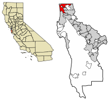
 Location of Daly City in San Mateo County, California. | ||
| Coordinates: 37°41′11″N 122°28′06″W / 37.68639°N 122.46833°W | ||
| Country | ||
| State | ||
| County | ||
| Incorporated | March 22, 1911[1] | |
| നാമഹേതു | John Daly | |
| • Mayor | Glenn Sylvester[2] | |
| • City council[2] | Council Members | |
| • State Assembly | Phil Ting (D)[3] | |
| • State Senator | Scott Wiener (D)[3] | |
| • U. S. Rep. | Jackie Speier (D)[4] | |
| • ആകെ | 7.64 ച മൈ (19.79 ച.കി.മീ.) | |
| • ഭൂമി | 7.64 ച മൈ (19.79 ച.കി.മീ.) | |
| • ജലം | 0.00 ച മൈ (0.00 ച.കി.മീ.) 0% | |
| ഉയരം | 344 അടി (105 മീ) | |
| • ആകെ | 1,01,123 | |
| • കണക്ക് (2016)[8] | 1,06,472 | |
| • റാങ്ക് | 1st in San Mateo County 65th in California | |
| • ജനസാന്ദ്രത | 13,936.13/ച മൈ (5,380.52/ച.കി.മീ.) | |
| സമയമേഖല | UTC-8 (Pacific) | |
| • Summer (DST) | UTC-7 (PDT) | |
| ZIP codes[9] | 94014–94017 | |
| Area codes[10][11] | 415/628, 650 | |
| FIPS code | 06-17918[7] | |
| GNIS feature IDs | 1658369, 2410291[6] | |
| വെബ്സൈറ്റ് | www | |
ഡാലി സിറ്റി, അമേരിക്കൻ ഐക്യനാടുകളിലെ കാലിഫോർണിയയിൽ സാൻ മാറ്റിയോ കൗണ്ടിയിലെ ഒരു നഗരമാണ്. 2014 ലെ കണക്കുകൾ പ്രകാരം ഈ നഗരത്തിലെ ജനസംഖ്യ 106,094 ആണ്.[12] സാൻഫ്രാൻസിസ്കോയുടെ തൊട്ടു തെക്ക് ഭാഗത്ത് സ്ഥിതി ചെയ്യുന്ന ഈ നഗരത്തിന് ഈ പേരു നൽകിയത്, വ്യവസായിയും ഭൂവുടമയുമായിരുന്ന ജോൺ ഡൊണാൾഡ് ഡാലിയെ ആദരിക്കുന്നതിനായാണ്.
ചരിത്രം[തിരുത്തുക]
2700 ബി.സി.യ്ക്കു മുമ്പുതന്നെ സാൻഫ്രാൻസിസ്കോ ഉൾക്കടൽ മേഖലയിൽ മനുഷ്യവാസമുള്ളതായി പുരാവസ്തു തെളിവുകൾ സൂചിപ്പിക്കുന്നു.[13] ഒഹ്ലോൺ ഭാഷാ വിഭാഗത്തിൽപ്പെട്ട ജനങ്ങൾ വടക്കൻ കാലിഫോർണിയയിൽ ആറാം നൂറ്റാണ്ടു മുതൽക്കേ അധിവസിച്ചുവന്നിരുന്നു.[14] പതിനാറാം നൂറ്റാണ്ടിന്റെ ആരംഭം മുതൽ സ്പെയിൻ അവരുടെ ഭൂപ്രദേശത്തിനുമേൽ അവകാശവാദം ഉന്നയിച്ചിരുന്നതെങ്കിലും, അൾട്ടാ കാലിഫോർണിയെ കോളനീകരിക്കുന്നതിനുള്ള ശ്രമത്തിന്റെ ഭാഗമായി ഡോൺ ഗാസ്പർ ഡി പോർട്ടോളയുടെ നേതൃത്വത്തിലുള്ള ഒരു പര്യവേക്ഷണ സംഘം സാൻ ഫ്രാൻസിസ്കോ ഉൾക്കടലിന്റെ അസ്തിത്വത്തെക്കുറിച്ചു മനസ്സിലാക്കി 1769 ൽ സാൻ ഫ്രാൻസിസ്കോ ഉൾക്കടൽ പ്രദേശത്ത് എത്തിച്ചേരുന്നതുവരെ യൂറോപ്യൻമാരുമായി താരതമ്യേന കുറച്ചുമാത്രമേ അവർക്ക് സമ്പർക്കമുണ്ടായിരുന്നുള്ളൂ.[15]
ഭൂമിശാസ്ത്രം[തിരുത്തുക]
അമേരിക്കൻ ഐക്യനാടുകളിലെ സെൻസസ് ബ്യൂറോയുടെ കണക്കനുസരിച്ച്, ഈ നഗരത്തിന്റെ മൊത്തം വിസ്തീർണം 7.7 ചതുരശ്ര മൈൽ (20 കി.മീ.2) ആണ്. ഇതുമുഴുവൻ കരപ്രദേശമാണ്. സാൻ ഫ്രാൻസിസ്കോ, ബ്രിസ്ബെയ്ൻ, സൌത്ത് സാൻ ഫ്രാൻസിസ്കോ, കോൾമ എന്നിവയാണ് ഡാലി സിറ്റിയുടെ അതിരുകളായി വരുന്നത്.
അവലംബം[തിരുത്തുക]
- ↑ "California Cities by Incorporation Date". California Association of Local Agency Formation Commissions. Archived from the original (Word) on November 3, 2014. Retrieved August 25, 2014.
- ↑ 2.0 2.1 "City Officials". City of Daly City, California. Archived from the original on 2019-01-07. Retrieved April 15, 2015.
- ↑ 3.0 3.1 "Statewide Database". UC Regents. Retrieved October 22, 2014.
- ↑ "California's 14-ആം Congressional District - Representatives & District Map". Civic Impulse, LLC.
- ↑ "2016 U.S. Gazetteer Files". United States Census Bureau. Retrieved Jul 19, 2017.
- ↑ 6.0 6.1 "City of Daly City". Geographic Names Information System. United States Geological Survey. Retrieved April 8, 2015.
- ↑ 7.0 7.1 "Daly City (city) QuickFacts". United States Census Bureau. Archived from the original on ഓഗസ്റ്റ് 18, 2012. Retrieved ഏപ്രിൽ 8, 2015.
- ↑ ഉദ്ധരിച്ചതിൽ പിഴവ്: അസാധുവായ
<ref>ടാഗ്;USCensusEst2016എന്ന പേരിലെ അവലംബങ്ങൾക്ക് എഴുത്തൊന്നും നൽകിയിട്ടില്ല. - ↑ "ZIP Code(tm) Lookup". United States Postal Service. Retrieved November 23, 2014.
- ↑ "North American Numbering Plan Letter" (PDF) (Press release). Bellcore. 1996-11-22. Archived from the original (PDF) on 2008-12-30. Retrieved 2009-06-26.
- ↑ "NANP Administration System". North American Numbering Plan Administration. Archived from the original on September 22, 2010. Retrieved 2009-06-26.
- ↑ "American FactFinder - Results". United States Census Bureau. Archived from the original on 2020-02-13. Retrieved May 22, 2015.
- ↑ Stewart, Suzanne B (November 2003). "Archaeological Research Issues For The Point Reyes National Seashore - Golden Gate National Recreation Area" (PDF). Sonoma State University - Anthropological Studies Center. p. 100. Retrieved June 12, 2008.
- ↑ Levy, Richard (1978). "Costanoan". In William C. Sturtevant and Robert F. Heizer (ed.). Handbook of North American Indians. Vol. 8. Washington, D.C.: Smithsonian Institution. p. 486. ISBN 0-16-004578-9.
- ↑ "Visitors: San Francisco Historical Information". City and County of San Francisco. Archived from the original on March 31, 2008. Retrieved June 10, 2008.


