കാമറില്ലൊ
Camarillo, California | ||
|---|---|---|
 Looking southeast across Camarillo from the northwestern hills on a warm sunny day in late October | ||
| ||
| Motto(s): "Las Personas Son la Ciudad" ("The People Are the City") | ||
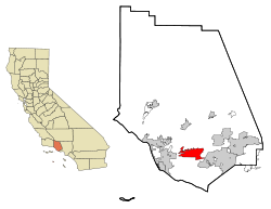
 കാലിഫോർണിയ സംസ്ഥാനത്തെ വെഞ്ചൂറ കൗണ്ടിയിലുള്ള സ്ഥാനം | ||
| Coordinates: 34°14′N 119°2′W / 34.233°N 119.033°W | ||
| രാജ്യം | ||
| സംസ്ഥാനം | ||
| കൗണ്ടി | വെഞ്ചൂറ | |
| റെയിൽ സ്റ്റേഷൻ | 1898 | |
| ഇൻകോർപ്പറേറ്റഡ് | October 22, 1964[1] | |
| നാമഹേതു | അഡോൾഫോയുടെയും ഹുവാൻ കാമറില്ലോയുടെയും പേരിൽ | |
| • മേയർ | ബിൽ ലിറ്റിൽ[2] | |
| • സ്റ്റേറ്റ് സെനറ്റർ | Hannah-Beth Jackson (D)[3] | |
| • CA അസംബ്ലി | Jacqui Irwin (D)[3] | |
| • U. S. Rep. | Julia Brownley (D)[4] | |
| • County supervisor | Kathy Long[5] | |
| • ആകെ | 19.543 ച മൈ (50.617 ച.കി.മീ.) | |
| • ഭൂമി | 19.528 ച മൈ (50.577 ച.കി.മീ.) | |
| • ജലം | 0.015 ച മൈ (0.040 ച.കി.മീ.) 0.08% | |
| ഉയരം | 177 അടി (54 മീ) | |
| • ആകെ | 65,201 | |
| • കണക്ക് (2013)[8] | 66,086 | |
| • ജനസാന്ദ്രത | 3,300/ച മൈ (1,300/ച.കി.മീ.) | |
| സമയമേഖല | UTC-8 (PST) | |
| • Summer (DST) | UTC-7 (PDT) | |
| ZIP codes | 93010–93012[9] | |
| ഏരിയ കോഡ് | 805 | |
| FIPS കോഡ് | 06-10046 | |
| GNIS ഫീച്ചർ ഐ.ഡി.കൾ | 1652682, 2409966 | |
| വെബ്സൈറ്റ് | www | |
അമേരിക്കൻ ഐക്യനാടുകളിലെ കാലിഫോർണിയ സംസ്ഥാനത്തിലെ വെഞ്ചുറ കൗണ്ടിയിലുള്ള ഒരു നഗരമാണ് കാമറില്ലൊ (/ˌkæməˈriːoʊ/ KAM-ə-REE-oh). 2000-ലെ സെൻസസിൽ 57,084 ആയിരുന്ന ജനസംഖ്യ 2010 ലെ സെൻസസ് പ്രകാരം 65,201 ആയി വർദ്ധിച്ചിരുന്നു. വെഞ്ചുറ ഫ്രീവേ (യു.എസ് റൂട്ട് 101) നഗരത്തിലെ പ്രാഥമിക പൊതുവീഥിയാണ്.
ഭൂമിശാസ്ത്രം
[തിരുത്തുക]കാമില്ലൊ നഗരം സ്ഥിതി ചെയ്യുന്ന അക്ഷാംശരേഖാംശങ്ങൾ 34°14′N 119°2′W / 34.233°N 119.033°W (34.2256, −119.0322) ആണ്.[10]
ഐക്യനാടുകളുടെ സെൻസസ് ബ്യൂറോയുടെ കണക്കനുസരിച്ച്, നഗരത്തിന്റെ ആകെ വിസ്തീർണ്ണം 19.5 ചതുരശ്ര മൈൽ ആണ് (51 കി.മീ2) ഇതിൽ 0.015 ചതുരശ്രമൈൽ പ്രദേശം (0.039 കി.മീ2) (0.08 ശതമാനം) ജലമാണ്.
ഒക്സ്നാർഡ് സമതലത്തിന്റെ കിഴക്കേ അറ്റത്തായി പ്ലസന്റ് താഴ്വരയിൽ[11] സ്ഥിതിചെയ്യുന്ന കാമില്ലോയുടെ വടക്കുഭാഗത്ത് സാന്താ സുസാന മലനിരകളും വടക്കുപടിഞ്ഞാറ് കാമറില്ലോ കുന്നുകളും കിഴക്ക് കൊണിജോ താഴ്വരയും തെക്കുഭാഗത്ത് സാന്താ മോണിക്ക പർവ്വതനിരകളുമാണ് അതിരുകൾ.
അവലംബം
[തിരുത്തുക]- ↑ "California Cities by Incorporation Date". California Association of Local Agency Formation Commissions. Archived from the original (Word) on November 3, 2014. Retrieved August 25, 2014.
- ↑ "Meet your city council". City of Camarillo, CA. Archived from the original on 2015-09-12. Retrieved April 19, 2015.
- ↑ 3.0 3.1 "Statewide Database". UC Regents. Retrieved October 20, 2014.
- ↑ "California's 26-ആം Congressional District - Representatives & District Map". Civic Impulse, LLC. Retrieved October 5, 2014.
- ↑ "Board of Supervisors". County of Venura. Retrieved February 1, 2015.
- ↑ "2010 Census U.S. Gazetteer Files – Places – California". United States Census Bureau.
- ↑ "Camarillo". Geographic Names Information System. United States Geological Survey. Retrieved October 20, 2014.
- ↑ 8.0 8.1 "Camarillo (city) QuickFacts". United States Census Bureau. Archived from the original on 2012-08-16. Retrieved March 20, 2015.
- ↑ "ZIP Code(tm) Lookup". United States Postal Service. Retrieved November 7, 2014.
- ↑ "US Gazetteer files: 2010, 2000, and 1990". United States Census Bureau. 2011-02-12. Retrieved 2011-04-23.
- ↑ U.S. Geological Survey "Feature Detail Report for: Pleasant Valley" Geographic Names Information System 19 January 1981
പുറത്തേയ്ക്കുള്ള കണ്ണികൾ
[തിരുത്തുക]![]() വിക്കിവൊയേജിൽ നിന്നുള്ള കാമറില്ലൊ യാത്രാ സഹായി
വിക്കിവൊയേജിൽ നിന്നുള്ള കാമറില്ലൊ യാത്രാ സഹായി
- ഔദ്യോഗിക വെബ്സൈറ്റ്

- Camarillo @ The Official Conejo Valley Website, a Web site with local history, events, and community information.
- കാമറില്ലൊ വിക്കി
- Camarillo Acorn Newspaper Archived 2011-03-07 at the Wayback Machine.

|
അൺഇൻകോർപ്പറേറ്റഡ് വെഞ്ചൂറ കൗണ്ടി | അൺഇൻകോർപ്പറേറ്റഡ് വെഞ്ചൂറ കൗണ്ടി | അൺഇൻകോർപ്പറേറ്റഡ് വെഞ്ചൂറ കൗണ്ടി | 
|
| അൺഇൻകോർപ്പറേറ്റഡ് വെഞ്ചൂറ കൗണ്ടി | സാന്താ റോസ വാലി | |||
| അൺഇൻകോർപ്പറേറ്റഡ് വെഞ്ചൂറ കൗണ്ടി | സാന്താ മോനിക്ക മലനിരകൾ | തൗസന്റ് ഓക്ക്സ് |


