
"ബാംബെർഗ്" എന്ന താളിന്റെ പതിപ്പുകൾ തമ്മിലുള്ള വ്യത്യാസം
Content deleted Content added
No edit summary റ്റാഗ്: 2017 സ്രോതസ്സ് തിരുത്ത് |
No edit summary |
||
| വരി 49: | വരി 49: | ||
File:Musikpavillon Hain Bamberg.JPG|Music pavilion in park Hain, Bamberg |
File:Musikpavillon Hain Bamberg.JPG|Music pavilion in park Hain, Bamberg |
||
</gallery> |
</gallery> |
||
[[വർഗ്ഗം:ജർമ്മനിയിലെ നഗരങ്ങൾ]] |
|||
16:22, 14 ജൂലൈ 2019-നു നിലവിലുണ്ടായിരുന്ന രൂപം
ബാംബെർഗ് | ||
|---|---|---|
 Old town hall (Altes Rathaus) in Bamberg | ||
| ||
Location of ബാംബെർഗ്  | ||
 ബാംബെർഗ്  ബാംബെർഗ് | ||
| Coordinates: 49°54′N 10°54′E / 49.900°N 10.900°E | ||
| Country | Germany | |
| State | Bavaria | |
| Admin. region | Upper Franconia | |
| District | Urban districts of Germany | |
| • Lord Mayor | Andreas Starke (SPD) | |
| • ആകെ | 54.62 ച.കി.മീ.(21.09 ച മൈ) | |
| ഉയരം | 262 മീ(860 അടി) | |
(2013-12-31)[1] | ||
| • ആകെ | 71,167 | |
| • ജനസാന്ദ്രത | 1,300/ച.കി.മീ.(3,400/ച മൈ) | |
| സമയമേഖല | CET/CEST (UTC+1/+2) | |
| Postal codes | 96047, 96049, 96050, 96051, 96052 | |
| Dialling codes | 0951 | |
| വാഹന റെജിസ്ട്രേഷൻ | BA | |
| വെബ്സൈറ്റ് | www.stadt.bamberg.de | |
| Type | Cultural | |
| Criteria | ii, iv | |
| Designated | 1993 (17th session) | |
| Reference no. | 624 | |
| State Party | Germany | |
| Region | Europe and North America | |

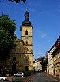
ജർമ്മനിയിലെ അപ്പർ ഫ്രാങ്കോണിയയിലെ ഒരു നഗരമാണ് ബാംബെർഗ്. മെയിൻ നദിയുയുടെ കരയിലാണ് ഈ നഗരം. 1993 ൽ നഗരത്തിന്റെ വലിയൊരു ഭാഗം യുനെസ്കോ ലോകപൈതൃകസ്ഥാനമായി പ്രഖ്യാപിച്ചു.
ചിത്രശാല
-
 Old town hall
 -
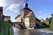 Old town hall with both bridges
 -
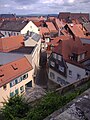
 Close-up of "Little Venice"
 -
 "Little Venice"
 -
 St Martin and Green Market
 -
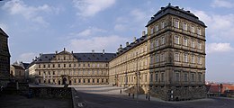 Neue Residenz (the "New Residence" of the prince-bishops)
 -
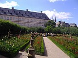 The Rose Garden at the Neue Residenz
 -
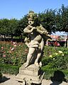 Rose Garden detail
 -
 Church of St Jacob
 -
 Bamberg roof tops from the Rose Garden
 -
 Music pavilion in park Hain, Bamberg


- ↑ "Fortschreibung des Bevölkerungsstandes". Bayerisches Landesamt für Statistik und Datenverarbeitung (in German). 31 December 2013.
{{cite web}}: CS1 maint: unrecognized language (link)