നുബ്ര താഴ്വര
Nubra ལྡུམ་ར། ldum ra | |
|---|---|
Town and Villages | |
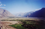
 Nubra Valley with Diskit Gompa and town immediately below and Hunder in the distance | |
| Nickname(s): Nubra | |
| Coordinates: 34°36′N 77°42′E / 34.6°N 77.7°E | |
| Country | |
| State | Jammu and Kashmir |
| District | Leh |
| സമയമേഖല | UTC+5:30 (IST) |

ലഡാക്ക് താഴ്വരയുടെ വടക്ക് കിഴക്കായി സ്ഥിതി ചെയ്യുന്ന ഒരു ത്രി-സായുധ താഴ്വരയാണ് നുബ്ര താഴ്വര .ലഡാക്കിലെ തലസ്ഥാനമായ ലേ ടൌണിൽ നിന്ന് 150 കിലോമീറ്റർ വടക്ക് ആണ് നുബ്റയുടെ തലസ്ഥാനം ഡിസ്കിറ്റ് സ്ഥിതി ചെയ്യുന്നത്. പ്രാദേശിക പണ്ഡിതന്മാർ അതിന്റെ യഥാർത്ഥ പേര് എൽഡുമ്ര (പൂക്കളുടെ താഴ്വര) ആണെന്ന് പറയുന്നു. ശ്യോക് നദി നുബ്ര അല്ലെങ്കിൽ സിയാച്ചൻ നദിയുമായി കൂടിച്ചേർന്ന് ലഡാക്ക്, കരക്കോറം എന്നിവയെ വേർതിരിക്കുന്ന ഒരു വലിയ താഴ്വര രൂപവത്കരിക്കുന്നു. സമുദ്രനിരപ്പിന് ഏകദേശം 3048 മീറ്റർ ഉയരമുള്ള താഴ്വരയുടെ ശരാശരി ഉയരം 10,000 അടിയാണ്. ലെ പട്ടണത്തിൽ നിന്ന് ഖർദുംഗ് ലാ ചുരത്തിൽ യാത്ര ചെയ്താൽ ഈ താഴ്വരയിലേക്ക് പോകാം. വിദേശത്തുനിന്നും നുബ്ര വാലി സന്ദർശിക്കാൻ ഒരു സംരക്ഷിത ഏജൻസി പെർമിറ്റ് ആവശ്യമാണ്. 2017 ഏപ്രിൽ 1 മുതൽ താഴ്വര സന്ദർശിക്കാൻ ഇൻഡ്യൻ പൌരന്മാർക്ക് ഇന്നർ ലൈൻ പെർമിറ്റ് ലഭിക്കേണ്ടതുണ്ട്.[1]
ചിത്രശാല
[തിരുത്തുക]-
A panoramic view over the Nubra Valley
-
Local map with North towards down
-
View from Diskit gompa on Nubra Valley
-
Seabuckthorn berries, Nubra valley, Ladakh
-
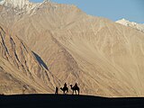
Bactrian camels
-
Silhoutte taken at Nubra Valley
-
This is enroute town called Hunder in the Nubra Valley.
-
Nubra Valley with Diskit Gompa and town immediately below and Hunder in the distance
-
Resort in Nubra Valley
ഇതും കാണുക
[തിരുത്തുക]- Ladakh
- Khardung La
- Siachen Glacier
- Thoise
- Chalunka
- Project HIMANK, road builders in the valley and creaters of curious sign boards
- Disket
അവലംബങ്ങൾ
[തിരുത്തുക]- ↑ Do You Need Inner Line Permit for Nubra, Pangong, Tso Moriri? Archived 2017-10-13 at the Wayback Machine., The Off: About Best Himalayan Adventures (TO ABHA), 26 April 2017.
ബാഹ്യ ലിങ്കുകൾ
[തിരുത്തുക]![]() വിക്കിവൊയേജിൽ നിന്നുള്ള നുബ്ര താഴ്വര യാത്രാ സഹായി
വിക്കിവൊയേജിൽ നിന്നുള്ള നുബ്ര താഴ്വര യാത്രാ സഹായി


