റൈഡിംഗ് മൌണ്ടൻ ദേശീയോദ്യാനം
| Riding Mountain National Park | |
|---|---|
ഐ.യു.സി.എൻ. ഗണം II (ദേശീയോദ്യാനം) | |
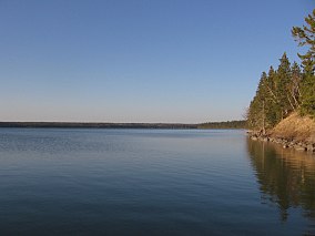
 Clear Lake, Riding Mountain National Park | |
Location of Riding Mountain National Park in Canada | |
| Location | Manitoba, Canada |
| Nearest city | Dauphin |
| Coordinates | പ്രയോഗരീതിയിൽ പിഴവ്: തിരിച്ചറിയാൻ കഴിയാത്ത വിരാമചിഹ്നം ","km 50°51′50″N 100°02′10″W / 50.86389°N 100.03611°W |
| Area | 2,969 കി.m2 (1,146 ച മൈ)[1] |
| Established | 1933 (National park) 1986 (Biosphere reserve) |
| Governing body | Parks Canada |
റൈഡിംഗ് മൌണ്ടൻ ദേശീയോദ്യാനം കാനഡയിലെ മനിറ്റോബയിൽ സ്ഥിതിചെയ്യുന്ന ഒരു ദേശീയോദ്യാനമാണ്. മനിറ്റോബ എന്ന നീണ്ട കിഴുക്കാം തുക്കായ മലഞ്ചെരിവിനു മുകളിലാണ് ഈ ദേശീയോദ്യാനത്തിൻറെ സ്ഥാനം. സംരക്ഷിത പ്രദേശം 2,969 ചതുരശ്രകിലോമീറ്റർ (1,146 ചതുരശ്രമൈൽ) പ്രദേശം ഉൾക്കൊള്ളുന്നു. വനങ്ങൾ തിങ്ങിനിറഞ്ഞ ദേശീയോദ്യാന പ്രദേശം, ചുറ്റുപാടുമുളള പ്രയറി പുൽമൈതാനങ്ങളിൽനിന്നു തികച്ചും വ്യത്യസ്തമായി നിലകൊള്ളുന്നു. പുൽമേടുകൾ, മലയോരപ്രദേശങ്ങൾ കിഴക്കൻ ഇലപൊഴിയും കാടുകൾ എന്നിങ്ങനെ ഈ പ്രദേശത്ത് ഒത്തുചേരുന്ന മൂന്ന് വ്യത്യസ്ത പരിസ്ഥിതി വ്യവസ്ഥകളെ സംരക്ഷിക്കുന്നതിനായിട്ടാണ് ദേശീയോദ്യാനം രൂപവൽക്കരിച്ചത്. ദേശീയോദ്യാനത്തിലൂടെ കടന്നുപോകുന്ന ഹൈവേ 10 വഴി ഇവിടെ ഏറ്റവും എളുപ്പത്തിൽ എത്തിച്ചേരാവുന്നതാണ്. ദേശീയോദ്യാനത്തിൻറെ അതിർത്തിക്കുള്ളിലുള്ള ഒരേയൊരു വാണിജ്യ കേന്ദ്രമാണ്, വാസാഗാമിംഗ് എന്ന ഉദ്യാനത്തിൻറെ തെക്കൻ പ്രവേശന കവാടം.[2]
അവലംബം
[തിരുത്തുക]- ↑ "Parks Canada - Riding Mountain National Park of Canada". Archived from the original on 2011-06-05. Retrieved 2017-06-15.
- ↑ Canada, Parks Canada Agency, Government of. "Parks Canada - Riding Mountain National Park - How to Get There". www.pc.gc.ca. Archived from the original on 2016-05-07. Retrieved 2016-04-19.
{{cite web}}: CS1 maint: multiple names: authors list (link)

