ബെൽഫാസ്റ്റ്
ബെൽഫാസ്റ്റ്
| |
|---|---|
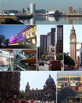
 Skyline and buildings throughout the City of Belfast | |
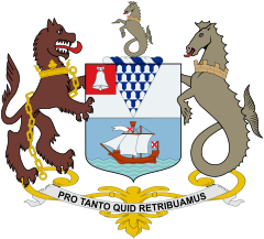
 Coat of arms with motto "Pro Tanto Quid Retribuamus" (Latin: "What shall we give in return for so much") | |
ബെൽഫാസ്റ്റ് shown within Northern Ireland | |
| Area | 44.4 sq mi (115 km2) |
| Population | City of Belfast: 333,001 (2016)[1] Urban Area: 483,418 (2016)[2] Metropolitan area: 671,559 (2011)[3] |
| Irish grid reference | J338740 |
| District | |
| County | |
| Country | Northern Ireland |
| Sovereign state | United Kingdom |
| Post town | BELFAST |
| Postcode district | BT1–BT17, BT29 (part), BT36 (part), BT58 |
| Dialling code | 028 |
| Police | Northern Ireland |
| Fire | Northern Ireland |
| Ambulance | Northern Ireland |
| EU Parliament | Northern Ireland |
| UK Parliament | |
| NI Assembly | |
| Website | www.belfastcity.gov.uk |

| Historical population | ||
|---|---|---|
| Year | Pop. | ±% p.a. |
| 1757 | 8,549 | — |
| 1782 | 13,105 | +1.72% |
| 1791 | 18,320 | +3.79% |
| 1806 | 22,095 | +1.26% |
| 1821 | 37,277 | +3.55% |
| 1831 | 53,287 | +3.64% |
| 1841 | 75,308 | +3.52% |
| 1851 | 97,784 | +2.65% |
| 1861 | 1,19,393 | +2.02% |
| 1871 | 1,74,412 | +3.86% |
| 1881 | 2,08,122 | +1.78% |
| 1891 | 2,55,950 | +2.09% |
| 1901 | 3,49,180 | +3.15% |
| 1911 | 3,86,947 | +1.03% |
| 1926 | 4,15,151 | +0.47% |
| 1937 | 4,38,086 | +0.49% |
| 1951 | 4,43,671 | +0.09% |
| 1961 | 4,15,856 | −0.65% |
| 1966 | 3,98,405 | −0.85% |
| 1971 | 3,62,082 | −1.89% |
| 1981 | 3,14,270 | −1.41% |
| 1991 | 2,79,237 | −1.17% |
| 2001 | 2,77,391 | −0.07% |
| 2006 | 2,67,374 | −0.73% |
| 2011 | 2,86,000 | +1.36% |
| 2014 | 3,33,000 | +5.20% |
| [4][5][6][7][8][9][10] | ||
യു.കെ.യുടെ ഭാഗമായ നോർത്തേൺ അയർലൻഡിന്റെ തലസ്ഥാനവും ഏറ്റവും വലിയ നഗരവുമാണ് ബെൽഫാസ്റ്റ്.(/ˈbɛlfɑːst/ or /-fæst/; from Irish: Béal Feirste, meaning "rivermouth of the sandbanks")[11] അയർലണ്ട് ദ്വീപിലെ രണ്ടാമത്തെ ഏറ്റവും വലിയ നഗരവുമാണ് ബെൽഫാസ്റ്റ്.[12] 2019-ലെ കണക്കുപ്രകാരം നഗരത്തിൽ 3,43,542 പേർ താമസിക്കുന്നു.[1]
അവലംബം[തിരുത്തുക]
- ↑ 1.0 1.1 "Belfast City Council". Retrieved 22 February 2016.
- ↑ The UK's major urban areas Office for National Statistics (Urban area of Belfast and connected settlements, Table 3.1, page 47)
- ↑ "Belfast Metropolitan Area Plan" (PDF). Archived from the original (PDF) on 2017-11-07. Retrieved 2017-12-08.
- ↑ Wakefield, Edward. An account of Ireland, statistical and political: in two volumes. Vol. 2. London: Longman, Hurst, Rees, Orme and Brown. pp. 693–694.
- ↑ "Census for post 1821 figures". Cso.ie. Archived from the original on 20 September 2010. Retrieved 12 August 2010.
- ↑ "Home". Histpop.Org. 2 ഏപ്രിൽ 2007. Archived from the original on 7 മേയ് 2016. Retrieved 13 നവംബർ 2010.
- ↑ NISRA. "Northern Ireland Statistics and Research Agency – Census Home Page". Nisranew.nisra.gov.uk. Archived from the original on 4 April 2010. Retrieved 12 August 2010.
- ↑ Lee, JJ (1981). "On the accuracy of the Pre-famine Irish censuses". In Goldstrom, J. M.; Clarkson, L. A. (eds.). Irish Populatioe, Economy, and Society: Essays in Honour of the Late K. H. Connell. Oxford, England: Clarendon Press.
- ↑ Mokyr, Joel; O Grada, Cormac (November 1984). "New Developments in Irish Population History, 1700–1850". The Economic History Review. 37 (4): 473–488. doi:10.1111/j.1468-0289.1984.tb00344.x. hdl:10197/1406. Archived from the original on 2012-12-04. Retrieved 2017-12-08.
- ↑ "Belfast City Council. Belfast: A Profile of the City. Demographics". Belfastcity.gov.uk. Archived from the original on 25 സെപ്റ്റംബർ 2010. Retrieved 12 ഓഗസ്റ്റ് 2010.
- ↑ Royal Mint – Belfast
- ↑ CityMetric
പുറത്തേയ്ക്കുള്ള കണ്ണികൾ[തിരുത്തുക]
Belfast എന്ന വിഷയവുമായി ബന്ധപ്പെട്ട ചിത്രങ്ങൾ വിക്കിമീഡിയ കോമൺസിലുണ്ട്.
![]() വിക്കിവൊയേജിൽ നിന്നുള്ള ബെൽഫാസ്റ്റ് യാത്രാ സഹായി
വിക്കിവൊയേജിൽ നിന്നുള്ള ബെൽഫാസ്റ്റ് യാത്രാ സഹായി


