
പ്രീൽബ്രുസ്യെ നാഷണൽ പാർക്ക്
| Prielbrusye National Park | |
|---|---|
| Russian: Приэльбрусье (национальный парк) (Also: Prielbrus'e) | |
ഐ.യു.സി.എൻ. ഗണം II (ദേശീയോദ്യാനം) | |
 Mt. Elbrus in Prielbrusye NP | |
 Location of Park | |
| Location | Kabardino-Balkaria |
| Nearest city | Nalchik |
| Coordinates | 43°21′11″N 42°33′39″E / 43.35306°N 42.56083°E |
| Area | 1,010,200 hectares (2,496,000 acres)* |
| Established | 1986 |
| Governing body | Ministry of Natural Resources and Environment (Russia) |
| Website | http://www.elbruspark.com/ |
പ്രിലെബ്രൂസ് ദേശീയ പാർക്ക് (റഷ്യൻ: Приэльбрусье (национальный парк)) (ഇംഗ്ലീഷിൽ "പ്രിൾബ്രൂസ്", "മൌണ്ട് എൽബ്രസ്") മൌണ്ട് എൽബ്രസിൻറെ മദ്ധ്യത്തിൽ സ്ഥിതിചെയ്യുന്നു. ഇത് സ്ഥിതിചെയ്യുന്നത് സമുദ്രനിരപ്പിൽ നിന്ന് 5,632 മീറ്റർ ഉയരമുള്ള എൽബ്രൂസ് എന്ന യൂറോപ്പിലെ ഏറ്റവും ഉയർന്ന മലയിലാണ്.
ചിത്രങ്ങൾ[തിരുത്തുക]
-
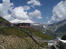 Visitor Cafe and Viewpoint to Mt. Elbrus, above the Baksan River valley
 -
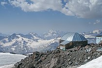 Shelter 11 on Mt. Elbrus
 -
 Baksan River valley
 -
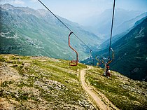 Cableway in the Elbrus region


