
സാക്രമെന്റൊ അന്താരാഷ്ട്ര വിമാനത്താവളം
(Sacramento International Airport എന്ന താളിൽ നിന്നും തിരിച്ചുവിട്ടതു പ്രകാരം)
| സാക്രമെന്റൊ അന്താരാഷ്ട്ര വിമാനത്താവളം | |||||||||||||||
|---|---|---|---|---|---|---|---|---|---|---|---|---|---|---|---|
 Lower floor of the new Terminal B. | |||||||||||||||
| Summary | |||||||||||||||
| എയർപോർട്ട് തരം | Public | ||||||||||||||
| ഉടമ | County of Sacramento | ||||||||||||||
| പ്രവർത്തിപ്പിക്കുന്നവർ | Sacramento County Airport System | ||||||||||||||
| Serves | Sacramento, California, U.S. | ||||||||||||||
| സ്ഥലം | Sacramento County, California, U.S. | ||||||||||||||
| Focus city for | |||||||||||||||
| സമുദ്രോന്നതി | 27 ft / 8 m | ||||||||||||||
| നിർദ്ദേശാങ്കം | 38°41′44″N 121°35′27″W / 38.69556°N 121.59083°W | ||||||||||||||
| വെബ്സൈറ്റ് | www | ||||||||||||||
| Map | |||||||||||||||
 SMF | |||||||||||||||
| റൺവേകൾ | |||||||||||||||
| |||||||||||||||
| Statistics (2016) | |||||||||||||||
| |||||||||||||||
കാലിഫോർണിയയിലെ സാക്രമെന്റൊ കൌണ്ടിയിൽ, സാക്രമെന്റൊ നഗരകേന്ദ്രത്തിന് 10 മൈൽ (16 കിലോമീറ്റർ) വടക്കുപടിഞ്ഞാറായി സ്ഥിതിചെയ്യുന്ന ഒരു വിമാനത്താവളമാണ് സാക്രമെന്റൊ അന്താരാഷ്ട്ര വിമാനത്താവളം. സാക്രമെന്റൊ കൗണ്ടി എയർപോർട്ട് സിസ്റ്റം ആണ് ഈ വിമാനത്താവളത്തിൻറെ നടത്തിപ്പ് നിർവ്വഹിക്കുന്നത്. സൗത്ത്വെസ്റ്റ് എയർലൈൻസ് ഇവിടനിന്നുള്ള പകുതിയോളം വിമാനയാത്രക്കാരെ വഹിക്കുന്നു.
ചരിത്രം[തിരുത്തുക]
സാക്രമെന്റൊ അന്താരാഷ്ട്ര വിമാനത്താവളം 1967 ഒക്ടോബർ 21 ന് സാക്രമെന്റൊ മെട്രോപോളിറ്റൻ എയർപോർട്ട് ആയി, 8600 അടി നീളമുള്ള റൺവേയോടുകൂടി തുറക്കപ്പെട്ടു.
ചിത്രശാല[തിരുത്തുക]
-
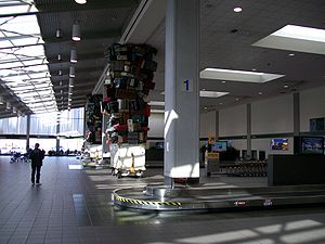 Baggage Claim at Terminal A
 -
 Loading Zone Terminal A
 -
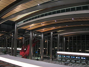 Overview of the Ticketing deck at Terminal B
 -
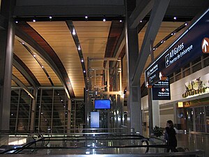 Connecter from Terminal B to Concourse Building
 -
 The third floor (shopping plaza) at Terminal B
 -
 Gates at the Terminal B Concourse
 -
 Elevators on Terminal B's third floor
 -
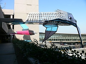 Dennis Oppenheim's "Flying Garden" installation (2005) outside the parking garage
 -
 Terminal B Automated People Mover


.jpg)
.jpg)
അവലംബം[തിരുത്തുക]
- ↑ FAA Airport Master Record for SMF (Form 5010 PDF), effective 2007-12-20
- ↑ "Sacramento International Airport Total Operations and Traffic". Sacramento County Airport System. January 2017. Retrieved January 27, 2017.
External links[തിരുത്തുക]
- FAA Airport Diagram (PDF), effective ഏപ്രിൽ 18, 2024
- Resources for this airport:
- AirNav airport information for KSMF
- ASN accident history for SMF
- FlightAware airport information and live flight tracker
- NOAA/NWS weather observations: current, past three days
- SkyVector aeronautical chart for KSMF
- FAA current SMF delay information
- FAA Airport Master Record for SMF (Form 5010 PDF)
- Sacramento International Airport (official site)
| International | |
|---|---|
| National | |
| Geographic | |