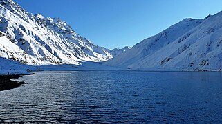
സൈഫുൽ മുലുക് തടാകം
| സൈഫുൽ മുലുക് തടാകം | |
|---|---|
 വടക്കൻ പാക്കിസ്ഥാനിലെ പർവതനിരകളിലെ മനോഹരമായ ഈ തടാകം ശ്രദ്ധേയമാണ് | |
| സ്ഥാനം | സൈഫുൾ മുലുക്ക് നാഷണൽ പാർക്ക് കഗാൻ താഴ്വര |
| നിർദ്ദേശാങ്കങ്ങൾ | 34°52′37″N 73°41′40″E / 34.876957°N 73.694485°E |
| Lake type | ആൽപൈൻ, ഗ്ലേഷ്യൽ തടാകം |
| പ്രാഥമിക അന്തർപ്രവാഹം | ഗ്ലേഷ്യൽ വാട്ടർ |
| Primary outflows | Stream (a tributary of Kunhar River) |
| Basin countries | പാകിസ്ഥാൻ |
| Surface area | 2.75 കി.m2 (29,600,000 sq ft) |
| പരമാവധി ആഴം | 113 അടി (34 മീ) |
| ഉപരിതല ഉയരം | 3,224 മീറ്റർ (10,577 അടി)[1] |
| അധിവാസ സ്ഥലങ്ങൾ | നരൻ |
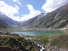
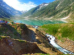
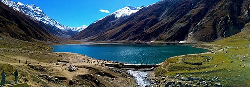
കഗാൻ താഴ്വരയുടെ വടക്കേ അറ്റത്ത് സൈഫുൽ മുലുക്ക് ദേശീയ ഉദ്യാനത്തിലെ നരൺ പട്ടണത്തിനടുത്തായി സ്ഥിതിചെയ്യുന്ന ഒരു പർവത തടാകമാണ് സൈഫുൽ മുലുക്ക് (ഉർദു: جھیل سیف الملوک). സമുദ്രനിരപ്പിൽ നിന്ന് 3,224 മീറ്റർ (10,578 അടി) ഉയരത്തിൽ, തടാകം വൃക്ഷരേഖയ്ക്ക് മുകളിലായി സ്ഥിതിചെയ്യുന്നു. പാകിസ്ഥാനിലെ ഏറ്റവും ഉയർന്ന തടാകങ്ങളിൽ ഒന്നാണിത്.
സ്ഥാനം
[തിരുത്തുക]
നരണിന് 9 കിലോമീറ്റർ (5.6 മൈൽ) വടക്ക്, [2][3] കഗാൻ താഴ്വരയുടെ വടക്കൻ ഭാഗത്ത്, ഖൈബർ പഖ്തുൻഖ്വയിലെ മൻസെറ ജില്ലയിലാണ് സൈഫുൾ മുലുക്ക് സ്ഥിതി ചെയ്യുന്നത്. താഴ്വരയിലെ ഏറ്റവും ഉയരമുള്ള കൊടുമുടിയായ മാലിക പർബത്ത് തടാകത്തിനടുത്താണ്.[4]
സവിശേഷതകൾ
[തിരുത്തുക]താഴ്വരയിലൂടെ കടന്നുപോകുന്ന അരുവിയുടെ ജലത്തെ തടയുന്ന ഗ്ലേഷ്യൽ മൊറെയ്നുകൾ കൊണ്ടാണ് സൈഫുൾ മുലുക്ക് രൂപപ്പെട്ടിരിക്കുന്നത്.[5]ഏകദേശം 300,000 വർഷങ്ങൾ പഴക്കമുള്ള ഗ്രേറ്റെർ പ്ലീസ്റ്റോസീൻ കാലഘട്ടത്തിലാണ് കഗാൻ താഴ്വര രൂപപ്പെട്ടത്. വർദ്ധിച്ചുവരുന്ന താപനിലയും ഹിമാനികൾ കുറയുന്നതും ഹിമാനികൾ ഒരിക്കൽ നിലനിന്നിരുന്ന ഒരു വലിയ നിമ്നഭാഗം അവശേഷിപ്പിച്ചു. ഉരുകുന്ന വെള്ളം തടാകത്തിലേക്ക് ശേഖരിക്കുന്നു.

നാടോടിക്കഥകൾ
[തിരുത്തുക]സൈഫുൽ മുലുക് തടാകത്തിന് ഒരു ഐതിഹാസിക രാജകുമാരന്റെ പേരാണ് നൽകിയിരിക്കുന്നത്. സൂഫി കവി മിയാൻ മുഹമ്മദ് ബക്ഷ് എഴുതിയ സെയ്ഫ് ഉൽ മുലുക്ക് എന്ന ഒരു കാല്പനികക്കഥ തടാകത്തെക്കുറിച്ച് പറയുന്നു.[6][7]തടാകത്തിൽ വച്ച് രാജകുമാരി ബദ്രി-ഉൽ-ജമാല രാജകുമാരിയുമായി പ്രണയത്തിലായ ഈജിപ്ഷ്യൻ രാജകുമാരൻ സൈഫുൽ മാലൂക്കിന്റെ കഥയാണ് ഇതിൽ പറയുന്നത്.[8][9]
ചിത്രശാല
[തിരുത്തുക]-
Lake Saiful Muluk under clouds
-
A view of lake in Wortez
-
Lake Saiful Muluk in a sunny day
-
A full view of Lake Saif-ul-Muluk
-
Lake Saif ul Malook in May 2017
-
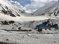
The lake freezes over in winter
-
Lake Saif ul Muluk in December 2012
-
Tourist point with Lake
-
A boat in Saiful Maluk Lake
-
Lake Saif-Ul-Mulook, Kaghan Valley, Pakistan
-
Lake Saif-Ul-Mulook at night
അവലംബം
[തിരുത്തുക]- ↑ "Surface Elevation of Lake Saiful Muluk". Dailytimes.com.pk. Archived from the original on 2021-02-28. Retrieved 1 June 2018.
- ↑ "Distance from Naran". Google Maps. Retrieved 10 June 2018.
- ↑ Ali, Ihsan. "Natural Heritage of Kaghan Valley". Mapping and Documentation of the Cultural Assets of Kaghan Valley, Mansehra (PDF) (Report). Islamabad: UNESCO. p. 46. Archived from the original (PDF) on 2018-07-12. Retrieved 20 September 2012.
- ↑ Hussain, Manzoor; Khan, Mir Ajab; Shah, Ghulam Mujtaba (5 March 2006). "Traditional Medicinal and Economic uses of Gymnosperms of Kaghan Valley, Pakistan". Ethnobotanical Leaflets. 10: 72. ISSN 1948-3570. Retrieved 20 September 2012.
- ↑ Ehlers, J.; Gibbard, P. L. (29 July 2004). Quaternary Glaciations - Extent and Chronology (2 ed.). Elsevier. pp. 305–306. ISBN 978-0444515933. Retrieved 16 September 2012.
- ↑ http://windsweptwords.com/2013/04/27/the-legend-of-Saif-ul-Muluk-part-iv/[പ്രവർത്തിക്കാത്ത കണ്ണി]
- ↑ "The News International: Latest News Breaking, Pakistan News". www.thenews.com.pk.[പ്രവർത്തിക്കാത്ത കണ്ണി]
- ↑ Javed, Asghar (23 June 2002). "Pristine lakes of the north". Dawn. Archived from the original on 13 July 2007. Retrieved 10 September 2016.
- ↑ "Saif-ul-Malook: The Lake of Fairies". 22 April 2016. Archived from the original on 2021-02-28. Retrieved 2021-02-15.


