വില്ലാമെറ്റ് നദി
| വില്ലാമെറ്റ് നദി | |
The Willamette passing through Downtown Portland in a photo from the 1980s
| |
| Name origin: From a Clackamas Native American village name[1] | |
| രാജ്യം | United States |
|---|---|
| സംസ്ഥാനം | Oregon |
| പോഷക നദികൾ | |
| - ഇടത് | Coast Fork Willamette River, Long Tom River, Marys River, Luckiamute River, Yamhill River, Tualatin River |
| - വലത് | Middle Fork Willamette River, McKenzie River, Calapooia River, Santiam River, Molalla River, Clackamas River |
| പട്ടണങ്ങൾ | Eugene, OR, Corvallis, OR, Albany, OR, Salem, OR, Newberg, OR, Wilsonville, OR, Portland, OR |
| സ്രോതസ്സ് | Confluence of Middle Fork Willamette River and Coast Fork Willamette River |
| - സ്ഥാനം | near Eugene, Lane County, Oregon |
| - ഉയരം | 438 ft (134 m) [2] |
| - നിർദേശാങ്കം | 44°01′23″N 123°01′25″W / 44.02306°N 123.02361°W [2] |
| അഴിമുഖം | Columbia River |
| - സ്ഥാനം | Portland, Multnomah County, Oregon |
| - ഉയരം | 10 ft (3 m) [2] |
| - നിർദേശാങ്കം | 45°39′10″N 122°45′53″W / 45.65278°N 122.76472°W [2] |
| നീളം | 187 mi (301 km) [3] |
| നദീതടം | 11,478 sq mi (29,730 km2) [4] |
| Discharge | for Morrison Bridge, Portland, 12.8 miles (20.6 km) from mouth [n 1] |
| - ശരാശരി | 33,010 cu ft/s (900 m3/s) |
| - max | 420,000 cu ft/s (11,900 m3/s) |
| - min | 4,200 cu ft/s (100 m3/s) |
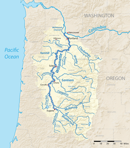
A map of the Willamette River, its drainage basin, major tributaries and major cities
| |
| Wikimedia Commons: Willamette River | |
വില്ലാമെറ്റ് നദി (i/wᵻˈlæmᵻt/ wil-lam-it) കൊളമ്പിയ നദിയുടെ ഒരു പ്രധാന പോഷകനദിയാണ്. ഇത് കൊളമ്പിയ നദിയ്ക്ക് 12 മുതൽ 15 വരെ ശതമാനം വരെ ജലപ്രവാഹത്തെ പ്രദാനം ചെയ്യുന്നു. വില്ലാമെറ്റ് നദിയുടെ പ്രധാന ശാഖയ്ക്ക് 187 മൈൽ (310 കിലോമീറ്റർ) നീളമാണുള്ളത്. ഇത് അമേരിക്കൻ ഐക്യനാടുകളിലെ വടക്കുപടിഞ്ഞാറൻ ഒറിഗോണിലൂടെ പൂർണ്ണമായി ഒഴുകുന്നു. ഒറിഗോൺ കോസ്റ്റ് റേഞ്ചിനും കാസ്കേഡ് റെഞ്ചിനും മദ്ധ്യത്തിലൂടെ വടക്കോട്ടൊഴുകന്ന വില്ലാമെറ്റ് നദിയും പോഷകനദികളും ഒത്തുചേർന്ന് വില്ലാമെറ്റ് താഴ്വര സൃഷ്ടിക്കുന്നു. ഈ താഴ്വരയിൽ ഒറിഗോൺ സംസ്ഥാനത്തെ മൂന്നിൽ രണ്ടു ജനങ്ങളും അധിവസിക്കുന്നു. സംസ്ഥാന തലസ്ഥാനമായ സേലം, വലിയ പട്ടണമായ പോർട്ടലാൻറ് എന്നിവ വില്ലാമെറ്റ് നദി കൊളമ്പിയ നദിയിലേയ്ക്കു പതിക്കുന്ന അഴിമുഖപ്രദേശത്തിനു ചുറ്റുമായാണ് സ്ഥിതി ചെയ്യുന്നത്.
അവലംബം[തിരുത്തുക]
- ↑ ഉദ്ധരിച്ചതിൽ പിഴവ്: അസാധുവായ
<ref>ടാഗ്;Brightഎന്ന പേരിലെ അവലംബങ്ങൾക്ക് എഴുത്തൊന്നും നൽകിയിട്ടില്ല. - ↑ 2.0 2.1 2.2 2.3 ഉദ്ധരിച്ചതിൽ പിഴവ്: അസാധുവായ
<ref>ടാഗ്;gnisഎന്ന പേരിലെ അവലംബങ്ങൾക്ക് എഴുത്തൊന്നും നൽകിയിട്ടില്ല. - ↑ "Facts About the Willamette River". Willamette Riverkeeper. Archived from the original on October 31, 2016. Retrieved November 16, 2016.
- ↑ Robbins, William G. "Willamette River". The Oregon Encyclopedia. Portland State University and the Oregon Historical Society. Retrieved May 19, 2014.
- ↑ "Water-Year Summary for Site USGS 14211720". U.S. Geological Survey. Retrieved January 8, 2017.
- ↑ ഉദ്ധരിച്ചതിൽ പിഴവ്: അസാധുവായ
<ref>ടാഗ്;Floodingഎന്ന പേരിലെ അവലംബങ്ങൾക്ക് എഴുത്തൊന്നും നൽകിയിട്ടില്ല.


