"ടിനിയൻ ദ്വീപ്" എന്ന താളിന്റെ പതിപ്പുകൾ തമ്മിലുള്ള വ്യത്യാസം
(ചെ.) 25 ഇന്റർവിക്കി കണ്ണികളെ വിക്കിഡാറ്റയിലെ d:Q325652 എന്ന താളിലേക്ക് മാറ്റിപ്പാർപ്പിച്ചിര... |
No edit summary |
||
| വരി 1: | വരി 1: | ||
{{prettyurl|Tinian}} |
{{prettyurl|Tinian}} |
||
{{Infobox |
{{Infobox islands |
||
| name = |
| name = Tinian |
||
| |
| image_name = Map Saipan Tinian islands closer.jpg |
||
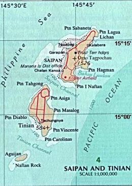
| image_caption = Tinian on an area map, southwest of [[Saipan]], showing waters around islands, and deeper Pacific section. |
|||
| image caption = '''ടിനിയൻ''' ഭൂപടത്തിൽ |
|||
| |
| image_size = |
||
| |
| map_image = Mariana Islands - Tinian.PNG |
||
| map=Pacific Ocean |
|||
| ⚫ | |||
| |
| map_caption = |
||
| |
| native_name = |
||
| native_name_link = |
|||
| ⚫ | |||
| ⚫ | |||
| location = [[ |
| location = [[Pacific Ocean]] |
||
| coordinates |
| coordinates = {{Coord|15|00|N|145|38|E|display=inline, title}} |
||
| archipelago = [[മറിയാനസ്]] |
|||
| |
| archipelago = [[Marianas]] |
||
| |
| total_islands = |
||
| major_islands = |
|||
| area = {{convert|101.01|km2|sqmi|abbr=on}} |
|||
| |
| area_km2 = 101.01 |
||
| |
| length_km = |
||
| |
| width_km = |
||
| |
| highest_mount = Mount Lasso |
||
| ⚫ | |||
| country = United States |
| country = United States |
||
| country_admin_divisions_title = Commonwealth |
|||
| country admin divisions title = കോമൺവെൽത്ത് |
|||
| |
| country_admin_divisions = [[Northern Mariana Islands]] |
||
| country_largest_city = [[San Jose, Northern Mariana Islands|San Jose]] |
|||
| country largest city = [[സാൻ ജോസ്, വടക്കൻ മറിയാന ദ്വീപുകൾ|സാൻ ജോസ്]] |
|||
| |
| population = 3,136 |
||
| population_as_of = 2010 |
|||
| population = 3,540 |
|||
| |
| density_km2 = |
||
| |
| ethnic_groups = |
||
| |
| additional_info = |
||
| additional info = |
|||
}} |
}} |
||
15:21, 12 ജൂലൈ 2020-നു നിലവിലുണ്ടായിരുന്ന രൂപം
 Tinian on an area map, southwest of Saipan, showing waters around islands, and deeper Pacific section. | |
 | |
| Geography | |
|---|---|
| Location | Pacific Ocean |
| Coordinates | 15°00′N 145°38′E / 15.000°N 145.633°E |
| Archipelago | Marianas |
| Area | 101.01 km2 (39.00 sq mi) |
| Highest elevation | 171 m (561 ft) |
| Highest point | Mount Lasso |
| Administration | |
United States | |
| Commonwealth | Northern Mariana Islands |
| Largest settlement | San Jose |
| Demographics | |
| Population | 3,136 (2010) |
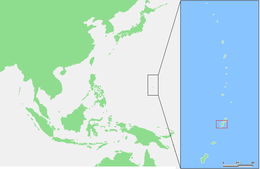
പശ്ചിമ ശാന്തസമുദ്രത്തിലെ കോമൺവെൽത്ത് ഒഫ് നോർത്തേൺ മറിയാന ദ്വീപ സമൂഹത്തിലെ മൂന്ന് പ്രധാന ദ്വീപുകളിലൊന്നാണ് ടിനിയൻ. ഏകദേശം 16 കി.മീ നീളവും 6 കി.മീ. വീതിയുമുള്ള ഈ ദ്വീപിനു ഏകദേശം 101 ച.കി.മീ. വിസ്തൃതിയുണ്ട്. ഈ ദ്വീപും ജനവാസമില്ലാത്ത സമീപ ദ്വീപ് അഗ്വിജനും ഉൾപ്പെടുന്നതാണ് ടിനിയൻ മുൻസിപ്പാലിറ്റി. 2000-ലെ കനേഷുമാരി പ്രകാരം ജനസംഖ്യ 3540 ആണ്. ദ്വീപുനിവാസികളിൽ ഭൂരിഭാഗവും മൈക്രോനേഷ്യൻ വംശജരാണ്.
1919 മുതൽ 1944 വരെ ലീഗ് ഒഫ് നേഷൻസിന്റെ അനുശാസനപ്രകാരം ജപ്പാന്റെ കീഴിലായിരുന്നു ടിനിയൻ ദ്വീപ്. ഇതിനുമുമ്പ് ജർമനധീനതയിലായിരുന്നു. ഒന്നാം ലോകയുദ്ധകാലത്ത് പസിഫിക്കിലെ ശക്തമായ ജാപ്പനീസ് താവളമായി ടിനിയൻ മാറി.
രണ്ടാം ലോകയുദ്ധത്തിൽ യുണൈറ്റഡ് സ്റ്റേറ്റ്സ് ഈ ദ്വീപ് തങ്ങളുടെ അധീനതയിലാക്കി (1944 ജൂല. 23). തുടർന്ന് ഇതൊരു പ്രധാന യു. എസ്. വ്യോമാസ്ഥാനമായി മാറി. ജപ്പാൻ ദ്വീപുകൾക്കെതിരെ യു. എസ്. നടത്തിയ വ്യോമാക്രമണങ്ങളിൽ ഭൂരിഭാഗവും ഈ ദ്വീപിൽനിന്നായിരുന്നു. 1947-ൽ യു. എൻ. ട്രസ്റ്റിഷിപ്പിനു കീഴിൽ യു. എസ്. അധീനപ്രദേശമായി മാറിയ ടിനിയൻ 1978-ൽ അമേരിക്കയുടെ കീഴിലുള്ള കോമൺവെൽത്തിന്റെ ഭാഗമായി. 1986-ൽ ദ്വീപുവാസികൾക്കും അമേരിക്കൻ പൗരത്വം നൽകി. 1990-ൽ യു. എൻ. ടിനിയന്റെ ട്രസ്റ്റിഷിപ്പ് പദവി റദ്ദാക്കി.
പുരാതന ചരിത്രാവശിഷ്ടങ്ങൾക്കും, കാട്ടുമൃഗങ്ങൾക്കും ഏറെ പ്രശസ്തമാണ് ടിനിയൻ ദ്വീപ്.


