
ബംഗാൾ
| ബംഗാൾ | |
|---|---|
| বাংলা, বঙ্গ | |
 Map of the Bengal region | |
| Coordinates | 24°00′N 88°00′E / 24.000°N 88.000°E |
| Largest Cities[1] | 23°25′N 90°13′E / 23.42°N 90.22°E
22°13′N 91°29′E / 22.22°N 91.48°E |
| Main language | Bengali (Bangla) |
| Area | 232,752 km² |
| Population (2001) | 245,598,679[2][3] |
| Density | 951.3/km²[2][3] |
| Infant mortality rate | Bangladesh - 33 per 1000 live births.[4] West Bengal - 31 per 1000 live births.[5] |
| Religions | Islam, Hinduism, Buddhism, Christianity |
| Demonym | Bengali |
| Websites | |
ബംഗ്ലാദേശും ഇന്ത്യയിലെ പശ്ചിമബംഗാൾ സംസ്ഥാനവും ഉൾപ്പെടുന്ന ഭൂമേഖലയാണ് ബംഗാൾ. ബംഗാളിയാണ് ഈ രണ്ടു മേഖലയിലേയും ജനങ്ങളുടെ പൊതുഭാഷ.
1905-ൽ ബ്രിട്ടീഷുകാർ ബംഗാളിനെ പശ്ചിമ, പൂർവബംഗാളുകളായി വിഭജിച്ചെങ്കിലും 1911-ൽ വീണ്ടും ഒരുമിപ്പിച്ചു. 1947-ൽ സ്വാതന്ത്ര്യാനന്തരം പൂർവബംഗാൾ പാകിസ്താന്റെ ഭാഗമായി കിഴക്കൻ പാകിസ്താൻ എന്നറിയപ്പെട്ടു. 1971-ൽ ഇന്ത്യന് സഹായത്തോടെ പാകിസ്താനിൽ നിന്നും സ്വാതന്ത്ര്യം നേടി ബംഗ്ലാദേശ് സ്വതന്ത്ര രാജ്യമായി.
ചരിത്രം[തിരുത്തുക]
മുഗൾ ഭരണകാലത്ത് ബംഗാൾ അവരുടെ നിയന്ത്രണത്തിലുള്ള ഒരു പ്രധാന മേഖലയായിരുന്നു. ബംഗാൾ പ്രവിശ്യയുടെ നയിബ് ആയി അതായത് സുബാദാറിന്റെ സഹായിയായി മുഗളർ നിയമിച്ച മുർഷിദ് ഖിലി ഖാൻ അധികാരം മുഗളരിൽ നിന്നും പിടിച്ചെടുത്തു[6].
ചിത്രശാല[തിരുത്തുക]
-
 The Bengal Tiger
 -
 Worker in a paddy, a common scene all over Bengal
 -
 Shaheed Minar, or the Martyr's monument, in Dhaka, commemorates the struggle for the Bengali language.
 -
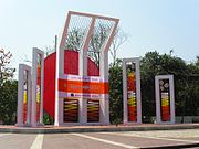
 Bhasha Smritistambha, or the Language Memorial, in Kolkata, commemorates thousand years of Bengali language and literature.
 -

-
 Dakshineswar Kali Temple in Kolkata, West Bengal.
 -


അവലംബം[തിരുത്തുക]
- ↑ "THE WORLD; Exiled Feminist Writer Tells Her Own Story". The New York Times.
- ↑ 2.0 2.1 "Provisional Population Totals: West Bengal". Census of India, 2001. Office of the Registrar General & Census Commissioner, India. Retrieved 26 August 2006.
- ↑ 3.0 3.1 ഉദ്ധരിച്ചതിൽ പിഴവ്: അസാധുവായ
<ref>ടാഗ്;WorldBankഎന്ന പേരിലെ അവലംബങ്ങൾക്ക് എഴുത്തൊന്നും നൽകിയിട്ടില്ല. - ↑ http://data.worldbank.org/indicator/SP.DYN.IMRT.IN
- ↑ "West Bengal - National Health Mission". SRS 2011. Ministry of Health & Family Welfare. 2011. Archived from the original on 2014-07-05. Retrieved 12 May 2014.
- ↑ "10-Eighteenth Century Political Formations". Social Science - Our Pasts-II. New Delhi: NCERT. 2007. p. 145. ISBN 81-7450-724-8.
{{cite book}}: Cite has empty unknown parameter:|coauthors=(help)
|
ഏഷ്യയുടെ ഭൂമിശാസ്ത്രവുമായി ബന്ധപ്പെട്ട ഈ ലേഖനം അപൂർണ്ണമാണ്. ഇതു വികസിപ്പിക്കുവാൻ സഹായിക്കുക. |