സിമാറോൺ നദി
| സിമാറോൺ നദി | |
|---|---|
 The Cimarron River, near Forgan, Oklahoma | |
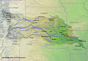
 Map of the Arkansas River basin with the Cimarron River highlighted. | |
| നദിയുടെ പേര് | |
| ഉദ്ഭവം | Río de los Carneros Cimarrones for River of the Wild Sheep |
| Country | United States |
| State | Colorado, Kansas, New Mexico, Oklahoma |
| Cities | Cushing, Oklahoma, Mannford, Oklahoma, Guthrie, Oklahoma |
| Physical characteristics | |
| പ്രധാന സ്രോതസ്സ് | Confluence of Dry Cimarron River and Carrizozo Creek Kenton, Cimarron County, Oklahoma 4,318 ft (1,316 m) 36°54′24″N 102°59′12″W / 36.90667°N 102.98667°W[1] |
| നദീമുഖം | ആർക്കൻസാ നദി Keystone Lake, at Westport, Pawnee County, Oklahoma 722 ft (220 m) 36°10′14″N 96°16′19″W / 36.17056°N 96.27194°W[1] |
| നീളം | 698 mi (1,123 km) |
| Discharge |
|
| നദീതട പ്രത്യേകതകൾ | |
| നദീതട വിസ്തൃതി | 18,950 sq mi (49,100 km2) |
സിമാറോൺ നദി ന്യൂ മെക്സിക്കോ, ഒക്ലഹോമ, കൊളറാഡോ, കാൻസാസ് സംസ്ഥാനങ്ങളിലൂടെ ഏകദേശം 698 മൈൽ (1,123 കിലോമീറ്റർ) ദൂരത്തിലൊഴുകുന്ന ഒരു നദിയാണ്. വടക്കുകിഴക്കൻ ന്യൂ മെക്സിക്കോയിലെ ഫോൾസമിന് പടിഞ്ഞാറ്, ജോൺസൺ മെസയിൽനിന്നാണ് ഇത് ഉറവെടുക്കുന്നത്. നദിയുടെ നീളത്തിന്റെ ഭൂരിഭാഗവും സ്ഥിതിചെയ്യുന്ന ഒക്ലഹോമയിൽ അത് പതിനൊന്ന് കൌണ്ടികളിലൂടെയോ കൌണ്ടി അതിർത്തികളിലൂടെയോ കടന്നുപോകുന്നു. നദി പ്രവഹിക്കുന്ന വഴിയിൽ പ്രധാന നഗരങ്ങളൊന്നുംതന്നെ സ്ഥിതിചെയ്യുന്നില്ല. ഒക്ലഹോമയിലെ കെന്റണിനടുത്തുള്ള ഒക്ലഹോമ പാൻഹാൻഡിലിലേക്ക് പ്രവേശിക്കുന്ന നദി, കൊളറാഡോയുടെ തെക്കുകിഴക്കൻ മൂലയിലൂടെ കൻസസിലേക്ക് കടന്ന്, ഒക്ലഹോമ പാൻഹാൻഡിൽ, കൻസാസ് എന്നിവിടങ്ങളിലേയ്ക്ക് വീണ്ടും പ്രവേശിച്ച്, അന്തിമമായി ഒക്ലഹോമയിലേക്ക് എത്തുകയും, അവിടെ അത് ഒക്ലഹോമയിലെ ടുൾസയ്ക്ക് പടിഞ്ഞാറ്, നദിയിലെ ഏക അണക്കെട്ടായ കീസ്റ്റോൺ റിസർവോയറിൽവച്ച് ആർക്കൻസാസ് നദിയുമായി ചേരുന്നു. ഏകദേശം 18,927 ചതുരശ്ര മൈൽ (49,020 ചതുരശ്ര കിലോമീറ്റർ) വിസ്തൃതിയുള്ളതാണ് നദിയുടെ നീർത്തടം.[4]
അവലംബം[തിരുത്തുക]
- ↑ 1.0 1.1 U.S. Geological Survey Geographic Names Information System: സിമാറോൺ നദി
- ↑ "USGS Gage #07160000 on the Cimarron River near Guthrie, OK" (PDF). National Water Information System. U.S. Geological Survey. 1938–2009. Archived (PDF) from the original on March 19, 2012. Retrieved November 21, 2010.
- ↑ "USGS Gage #07160000 on the Cimarron River near Guthrie, OK" (PDF). National Water Information System. U.S. Geological Survey. 1938–2009. Archived (PDF) from the original on March 19, 2012. Retrieved November 21, 2010.
- ↑ Larry O'Dell, "Cimarron River," Encyclopedia of Oklahoma History and Culture. Archived April 2, 2015, at the Wayback Machine. Accessed March 6, 2015.
