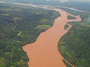
ഉകായാലി നദി
| ഉകായാലി നദി | |
|---|---|
 ടാംബോ (ചുവടെ നിന്ന്) ഉറുബാംബ നദികളുടെ (പശ്ചാത്തലത്തിൽ വലത്) സംഗമത്താൽ രൂപംകൊളളുന്ന ഉകയാലി നദി (പശ്ചാത്തലത്തിൽ ഇടത്) | |
 Map of the Amazon Basin with the Ucayali River highlighted | |
| Country | Peru |
| Physical characteristics | |
| പ്രധാന സ്രോതസ്സ് | confluence of the Tambo and Urubamba Rivers Atalaya, Ucayali, Peru |
| നദീമുഖം | Amazon River confluence with Marañón River, Loreto, Peru |
| നീളം | 1,460 km (910 mi)[1] |
| Discharge |
|
ഉകായാലി നദി പെറുവിലെ അരെക്വപ്പാ മേഖലയിൽ ടിറ്റിക്കാക്ക തടാകത്തിൽ നിന്ന് ഏകദേശം 110 കിലോമീറ്റർ (68 മൈൽ) വടക്കുനിന്ന് ഉത്ഭവിക്കുന്നു. മറാനോൺ, ഉകായാലി നദികളുടെ സംഗമസ്ഥാനത്ത് നൗട്ട നഗരത്തിനു സമീപത്തുവച്ച് ഇത് ആമസോൺ നദിയായി പേരെടുക്കുന്നു. ഉസായലി നദി ആമസോൺ നദിയുടെ ഒരു പ്രധാന പോഷകനദിയായി മാറുന്നു. നീണ്ടുകിടക്കുന്ന ഭാഗങ്ങളിലെ ശീഘ്രഗതിയിലുള്ള ജലപാതങ്ങൾ കാരണമായി ഇവിടെ ജലഗതാഗതം തടയപ്പെട്ടിരിക്കുന്നു. ഉകായാലി നദിയോരത്താണ് പുക്കാൽപ്പാ നഗരം സ്ഥിതിചെയ്യുന്നത്.
അവലംബം[തിരുത്തുക]
- ↑ Ziesler, R.; Ardizzone, G.D. (1979). "Amazon River System". The Inland waters of Latin America. Food and Agriculture Organization of the United Nations. ISBN 92-5-000780-9. Archived from the original on 8 November 2014.
