
പ്രമാണം:Map of Transcontiental nations.png

ഈ പ്രിവ്യൂവിന്റെ വലിപ്പം: 800 × 351 പിക്സലുകൾ. മറ്റ് റെസലൂഷനുകൾ: 320 × 140 പിക്സലുകൾ | 640 × 281 പിക്സലുകൾ | 1,425 × 625 പിക്സലുകൾ.
പൂർണ്ണ വലിപ്പം (1,425 × 625 പിക്സൽ, പ്രമാണത്തിന്റെ വലിപ്പം: 40 കെ.ബി., മൈം തരം: image/png)
| ഈ പ്രമാണം വിക്കിമീഡിയ കോമൺസിൽ നിന്നുള്ളതാണ്. പ്രമാണത്തെക്കുറിച്ചുള്ള വിവരണം താഴെ കൊടുത്തിരിക്കുന്നു.
|
Misspelt title of map: Transcontiental>Transcontinental
Only two shades of blue distinguishable.
ചുരുക്കം
| വിവരണം |
Afrikaans: Kaart van Transkontinentale nasies.
state met 'n aangrensende grens
state met 'n nie-aangrensende grens
state met 'n gebied wat transkontinentale Dansk: Kort over transkontinentale nationer.
stater med en sammenhængende grænse.
stater med en ikke-sammenhængende grænse.
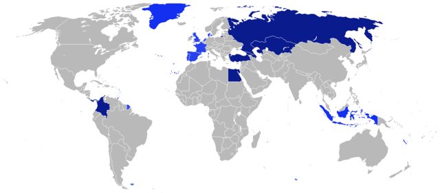
stater med et område, der er transkontinentale. English: Map of transcontinental nations.
states with a contiguous boundary.
states with a non-contiguous boundary.
states with a territory that's transcontinental. Español: Mapa de las naciones transcontinental.
estados con un límite contigua.
estados con un límite no contigua.
Estados con un área de Transcontinental. Français : Carte des pays transcontinentaux.
pays ayant une continuité territoriale de ses frontières.
pays sans continuité territoriale de ses frontières.
pays ayant un territoire transcontinental. Nederlands: Kaart van Transcontinentale naties.
staten met een aangrenzende grens.
staten met een niet-aangrenzende grens.
staten met een gebied dat transcontinentaal is. Türkçe: Kıtalararası Ülkeler.
Bitişik sınır ülkeleri.
Sınırı bitişik olmayan ülkeler.
Denizaşırı toprağı bulunan ülkeler. Русский: Карта Трансконтинентальных стран.
Государства с примыкающей границей.
Государства с несмежной границей.
Государства с Трансконтинентальной площадью. العربية : خريطة الدول عابرة للقارات.
الدول التي لها حدود متماسك.
الدول التي لها حدود غير متجاورة.
الدول التي لديها أراضي هذا هو عابر للقارات. |
| തീയതി | |
| സ്രോതസ്സ് | സ്വന്തം സൃഷ്ടി |
| സ്രഷ്ടാവ് | $200inaire |
അനുമതി
ഈ സൃഷ്ടിയുടെ പകർപ്പവകാശ ഉടമയായ ഞാൻ, താഴെ പറയുന്ന അനുമതിയിൽ ഈ സൃഷ്ടി ഇതിനാൽ പ്രസിദ്ധീകരിക്കുന്നു:
ഈ പ്രമാണത്തിന് അനുമതി നൽകപ്പെട്ടിരിക്കുന്നത് ക്രിയേറ്റീവ് കോമൺസ് ആട്രിബ്യൂഷൻ-ഷെയർ എലൈക് 3.0 അൺപോർട്ടഡ് അനുവാദപത്ര പ്രകാരമാണ്.
- താങ്കൾക്കുള്ള സ്വാതന്ത്ര്യങ്ങൾ:
- പങ്ക് വെയ്ക്കൽ – കൃതി പകർത്താനും, വിതരണം ചെയ്യാനും, പ്രസരിപ്പിക്കാനും
- പുനഃമിശ്രണം ചെയ്യൽ – കൃതി അനുയുക്തമാക്കാൻ
- താഴെ പറയുന്ന ഉപാധികൾ പാലിക്കുക:
- കടപ്പാട് – രചയിതാവോ അനുമതിയുള്ളയാളോ വ്യക്തമാക്കിയിട്ടുള്ള വിധത്തിൽ കൃതിയ്ക്കുള്ള കടപ്പാട് താങ്കൾ നൽകിയിരിക്കണം. താങ്കൾക്കിത് ഏത് വിധത്തിൽ വേണമെങ്കിലും ചെയ്യാവുന്നതാണ്, പക്ഷേ അത് അവർ താങ്കളേയോ താങ്കളുടെ ഉപയോഗത്തേയോ അടിച്ചേൽപ്പിച്ചതു പോലെയാവരുത്.
- ഇതു പോലെ പങ്ക് വെയ്ക്കുക – ഈ സൃഷ്ടിയെ പുനഃമിശ്രണം ചെയ്തോ രൂപാന്തരപ്പെടുത്തിയോ അടിസ്ഥാനപ്പെടുത്തിയോ ഉണ്ടാക്കുന്നവ; താങ്കളുടെ സംഭാവനയടക്കമുള്ള സൃഷ്ടി യഥാർത്ഥ സൃഷ്ടിയുടെ അതേ അല്ലെങ്കിൽ അനുരൂപമായ ഉപയോഗാനുമതിയിൽ മാത്രമേ താങ്കൾ വിതരണം ചെയ്യാവൂ.
പ്രമാണ നാൾവഴി
ഏതെങ്കിലും തീയതി/സമയ കണ്ണിയിൽ ഞെക്കിയാൽ പ്രസ്തുതസമയത്ത് ഈ പ്രമാണം എങ്ങനെയായിരുന്നു എന്നു കാണാം.
| തീയതി/സമയം | ലഘുചിത്രം | അളവുകൾ | ഉപയോക്താവ് | അഭിപ്രായം | |
|---|---|---|---|---|---|
| നിലവിലുള്ളത് | 19:41, 4 ഓഗസ്റ്റ് 2014 | | 1,425 × 625 (40 കെ.ബി.) | KronosLine | Added South Sudan, removed Kosovo (either include all breakaway regions or none) |
| 10:32, 5 ഏപ്രിൽ 2014 |  | 1,425 × 625 (33 കെ.ബി.) | SeeSchloss | Added French overseas territories (French Guyana, Southern territories, St Pierre & Miquelon, Guadeloupe, Martinique, Réunion, Mayotte, New Caledonia, Wallis & Futuna - I couldn't spot French Polynesia islands on the map) as well as Corsica. Added Spa... | |
| 04:09, 25 ഫെബ്രുവരി 2014 |  | 1,425 × 625 (40 കെ.ബി.) | Scoelho86 | +POR | |
| 04:33, 31 ജനുവരി 2014 |  | 1,425 × 625 (40 കെ.ബി.) | Scoelho86 | +COL | |
| 07:48, 13 ജൂൺ 2012 |  | 1,425 × 625 (57 കെ.ബി.) | $200inaire | Fix some errors and flaws in the map | |
| 23:16, 10 ജൂൺ 2012 |  | 1,425 × 625 (56 കെ.ബി.) | $200inaire |
പ്രമാണത്തിന്റെ ഉപയോഗം
താഴെ കാണുന്ന താളിൽ ഈ ചിത്രം ഉപയോഗിക്കുന്നു:
പ്രമാണത്തിന്റെ ആഗോള ഉപയോഗം
താഴെ കൊടുത്തിരിക്കുന്ന മറ്റ് വിക്കികൾ ഈ പ്രമാണം ഉപയോഗിക്കുന്നു:
- arz.wikipedia.org സംരംഭത്തിലെ ഉപയോഗം
- da.wikipedia.org സംരംഭത്തിലെ ഉപയോഗം
- la.wikipedia.org സംരംഭത്തിലെ ഉപയോഗം