ലെന നദി
ദൃശ്യരൂപം
| Lena | |
|---|---|
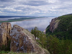
 The Lena Pillars along the river near Yakutsk | |
 Lena watershed | |
| Country | Russia |
| Physical characteristics | |
| പ്രധാന സ്രോതസ്സ് | Baikal Mountains Kachugsky District, Irkutsk Oblast 1,640 മീ (5,380 അടി) 53°58′3″N 107°52′56″E / 53.96750°N 107.88222°E (approximately) |
| നദീമുഖം | Lena Delta Arctic Ocean, Laptev Sea 0 മീ (0 അടി) 72°24′31″N 126°41′05″E / 72.4087°N 126.6847°E |
| നീളം | 4,294 കി.മീ (14,088,000 അടി) |
| വീതി |
|
| ആഴം |
|
| Discharge |
(Period of data: 1970-1999)17,067 m3/s (602,700 cu ft/s)[2] 15,500 m3/s (550,000 cu ft/s)[3]
Lena Delta, Laptev Sea, Russia (Period of data: 1984-2018)577 കി.m3/a (18,300 m3/s)[1] (Period of data: 1940-2019) 545.7 കി.m3/a (17,290 m3/s)[4] |
| Discharge (location 2) | |
| Discharge (location 3) |
|
| Discharge (location 4) |
|
| Discharge (location 5) |
|
| നദീതട പ്രത്യേകതകൾ | |
| നദീതട വിസ്തൃതി | 2,460,742 കി.m2 (950,098 ച മൈ) to 2,490,000 കി.m2 (960,000 ച മൈ) |
| പോഷകനദികൾ | |
 | |
സൈബീരിയയിൽ നിന്നും ഉത്ഭവിച്ചു ആർട്ടിക് കടലിൽ പതിക്കുന്ന ഒരു റഷ്യൻ നദി ആണ് ലെന നദി. 4,294 കി.മീ (2,668 മൈൽ) നീളമുള്ള ലെന നദിക്ക് 2,490,000 ചതുരശ്ര കിലോമീറ്റർ (960,000 ചതുരശ്ര മൈൽ) വിസ്തൃതിയുള്ള നീർത്തടം ഉണ്ട്. ഇത് ലോകത്തിലെ 11-മത്തെ ഏറ്റവും നീളം കൂടിയ നദി ആണ് . സൈബീരിയയിലെ ബൈക്കൽ മലനിരകളിൽ ആണ് ഈ നദിയുടെ ഉത്ഭവ സ്ഥാനം.
അവലംബം
[തിരുത്തുക]- ↑ 1.0 1.1 1.2 Stadnyk, Tricia A.; Tefs, A.; Broesky, M.; Déry, S. J.; Myers, P. G.; Ridenour, N. A.; Koenig, K.; Vonderbank, L.; Gustafsson, D. (28 May 2021). "Changing freshwater contributions to the Arctic". Elementa: Science of the Anthropocene. 9 (1): 00098. Bibcode:2021EleSA...9...98S. doi:10.1525/elementa.2020.00098. S2CID 236682638.
- ↑ "Variations of the Present-Day Annual and Seasonal Runoff in the Far East and Siberia with the Use of Regional Hydrological and Global Climate Models" (PDF). 2018.
- ↑ http://www.abratsev.narod.ru/biblio/sokolov/p1ch23b.html, Sokolov, Eastern Siberia // Hydrography of USSR. (in russian)
- ↑ "River Discharge". Archived from the original on 2021-09-21. Retrieved 2024-12-01.
- ↑ 5.0 5.1 Gautier, Emmanuèle; Dépret, Thomas; Cavero, Julien; Costard, François; Virmoux, Clément; Fedorov, Alexander; Konstantinov, Pavel; Jammet, Maël; Brunstein, Daniel (August 2021). "Fifty-year dynamics of the Lena River islands (Russia): Spatio-temporal pattern of large periglacial anabranching river and influence of climate change". Science of the Total Environment. 783: 147020. Bibcode:2021ScTEn.78347020G. doi:10.1016/j.scitotenv.2021.147020. PMID 34088165. S2CID 234836524.
