ലാസ് മെഡുലാസ്
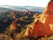
 Panoramic view of Las Médulas | |
| യുനെസ്കോ ലോക പൈതൃക സ്ഥാനം | |
|---|---|
| സ്ഥാനം | സ്പെയിൻ |
| Area | 1,115 ha (120,000,000 sq ft) |
| Includes | Estéiles de Valdebría, Estéiles de Yeres, Estéiles de la Balouta, Zone principal de la mina de oro de Las Médulas |
| മാനദണ്ഡം | i, ii, iii, iv[2] |
| അവലംബം | 803 |
| നിർദ്ദേശാങ്കം | 42°27′32″N 6°45′36″W / 42.45889°N 6.76000°W |
| രേഖപ്പെടുത്തിയത് | 1997 (21st വിഭാഗം) |
| വെബ്സൈറ്റ് | patrimonionatural |
ലാസ് മെഡുലാസ് (Galician: As Médulas), എൽ ബീർസൊ മേഖലയിലെ (ലിയോൺ പ്രോവിൻസ്, കാസിൽ & ലിയോൺ, സ്പെയിൻ) പോൻഫെറഡാ നഗരത്തിന് സമീപമുള്ള ചരിത്രപരമായ ഒരു ഖനന സൈറ്റാണ്.റോമാ സാമ്രാജ്യത്തിനുള്ളിലെ ഏറ്റവും പ്രധാനപ്പെട്ടതും തുറസായതുമായ സ്വർണ്ണ ഖനിയായിരുന്നു അത്.[3] ലാസ് മെഡുലാസ് സാംസ്ക്കാരിക ഭൂപ്രദേശം യുനെസ്കോ ലോക പൈതൃക സ്ഥലങ്ങളിൽ ഒന്നായി കണക്കാക്കപ്പെടുന്നു. LIDAR ലേസർ സാങ്കേതികവിദ്യയുപയോഗിച്ചു 2014 ൽ നടത്തിയ വിപുലമായ സർവ്വേകൾ റോമൻ കാലഘട്ടത്തിൽ ഈ പ്രദേശത്തു നടന്ന വ്യാപകമായ ഖനന പ്രവൃത്തികളെ സ്ഥിരീകരിച്ചു.[4]
അവലംബം[തിരുത്തുക]
- ↑ Error: Unable to display the reference properly. See the documentation for details.
- ↑ Error: Unable to display the reference properly. See the documentation for details.
- ↑ El parque cultural | Paisaje cultural
- ↑ LIDAR surveys at Las Médulas.

