
പ്രമാണം:Trails of Tears en.png

ഈ പ്രിവ്യൂവിന്റെ വലിപ്പം: 785 × 600 പിക്സലുകൾ. മറ്റ് റെസലൂഷനുകൾ: 314 × 240 പിക്സലുകൾ | 628 × 480 പിക്സലുകൾ | 1,005 × 768 പിക്സലുകൾ | 1,280 × 978 പിക്സലുകൾ | 2,025 × 1,547 പിക്സലുകൾ.
പൂർണ്ണ വലിപ്പം (2,025 × 1,547 പിക്സൽ, പ്രമാണത്തിന്റെ വലിപ്പം: 3.04 എം.ബി., മൈം തരം: image/png)
| ഈ പ്രമാണം വിക്കിമീഡിയ കോമൺസിൽ നിന്നുള്ളതാണ്. പ്രമാണത്തെക്കുറിച്ചുള്ള വിവരണം താഴെ കൊടുത്തിരിക്കുന്നു.
|
ചുരുക്കം
| വിവരണം |
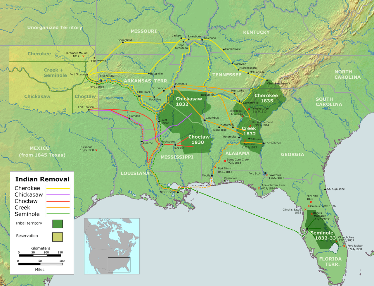
English: Map of the route of the Trails of Tears — depicting the route taken to relocate Native Americans from the Southeastern United States between 1836 and 1839.
|
||||
| തീയതി | |||||
| സ്രോതസ്സ് |
ഇതുപയോഗിച്ചുള്ള സ്വന്തം സൃഷ്ടി::
|
||||
| സ്രഷ്ടാവ് | User:Nikater | ||||
| അനുമതി (ഈ പ്രമാണത്തിന്റെ പുനരുപയോഗം) |
|
||||
| മറ്റു പതിപ്പുകൾ |
|

പ്രമാണ നാൾവഴി
ഏതെങ്കിലും തീയതി/സമയ കണ്ണിയിൽ ഞെക്കിയാൽ പ്രസ്തുതസമയത്ത് ഈ പ്രമാണം എങ്ങനെയായിരുന്നു എന്നു കാണാം.
| തീയതി/സമയം | ലഘുചിത്രം | അളവുകൾ | ഉപയോക്താവ് | അഭിപ്രായം | |
|---|---|---|---|---|---|
| നിലവിലുള്ളത് | 18:37, 4 സെപ്റ്റംബർ 2007 | | 2,025 × 1,547 (3.04 എം.ബി.) | Nikater | {{Information |Description=Trails of Tears (English version) |Source=Own work by Nikater, submitted to the public domain. Background map courtesy of Demis, www.demis.nl and Wilcomb E. Washburn (Hrsg.) ''Handbook of North American Indians.'' Vol. 4: Histor |
| 07:55, 4 സെപ്റ്റംബർ 2007 |  | 2,025 × 1,547 (3.04 എം.ബി.) | Nikater | {{Information |Description=Trails of Tears (English version) |Source=Own work by Nikater, submitted to the public domain. Background map courtesy of Demis, www.demis.nl and Wilcomb E. Washburn (Hrsg.) ''Handbook of North American Indians.'' Vol. 4: Histor |
പ്രമാണത്തിന്റെ ഉപയോഗം
താഴെ കാണുന്ന താളിൽ ഈ ചിത്രം ഉപയോഗിക്കുന്നു:
പ്രമാണത്തിന്റെ ആഗോള ഉപയോഗം
താഴെ കൊടുത്തിരിക്കുന്ന മറ്റ് വിക്കികൾ ഈ പ്രമാണം ഉപയോഗിക്കുന്നു:
- af.wikipedia.org സംരംഭത്തിലെ ഉപയോഗം
- am.wikipedia.org സംരംഭത്തിലെ ഉപയോഗം
- ar.wikipedia.org സംരംഭത്തിലെ ഉപയോഗം
- bcl.wikiquote.org സംരംഭത്തിലെ ഉപയോഗം
- be.wikipedia.org സംരംഭത്തിലെ ഉപയോഗം
- bg.wikipedia.org സംരംഭത്തിലെ ഉപയോഗം
- bn.wikipedia.org സംരംഭത്തിലെ ഉപയോഗം
- ca.wikipedia.org സംരംഭത്തിലെ ഉപയോഗം
- Destí Manifest
- Neteja ètnica
- Andrew Jackson
- James Monroe
- Guerres índies
- Deportació dels indis dels Estats Units
- Camí de les Llàgrimes
- Territori Indi
- Tractat de Dancing Rabbit Creek
- Camí de les Llàgrimes choctaw
- Plantilla:Deportació ameríndia
- Tractat de Payne's Landing
- Indian Removal Act
- Tractat de Doak's Stand
- Tractat de Hopewell
- Tractat de Prairie du Chien
- Usuari:Carmallola/Neteja ètnica
- cs.wikipedia.org സംരംഭത്തിലെ ഉപയോഗം
- de.wikipedia.org സംരംഭത്തിലെ ഉപയോഗം
- en.wikipedia.org സംരംഭത്തിലെ ഉപയോഗം
- Indian removal
- Winfield Scott
- History of the United States
- Trail of Tears
- Five Civilized Tribes
- History of the Southern United States
- Portal:Oklahoma
- History of Oklahoma
- History of Arkansas
- Presidency of Andrew Jackson
- User talk:Kevin1776/Archive 3
- Aboriginal title in the United States
- Cherokee Nation (1794–1907)
- User:Boompole/sandbox
- Oklahoma Organic Act
- User:Joelton Ivson/Gather lists/24319 – Indígenas América do Norte
- User:Squeakinglemur/sandbox
ഈ പ്രമാണത്തിന്റെ കൂടുതൽ ആഗോള ഉപയോഗം കാണുക.