
പ്രമാണം:Seas of the Philippines.svg

പൂർണ്ണ വലിപ്പം (എസ്.വി.ജി. പ്രമാണം, നാമമാത്രമായ 2,106 × 3,971 പിക്സലുകൾ, പ്രമാണത്തിന്റെ വലിപ്പം: 517 കെ.ബി.)
| ഈ പ്രമാണം വിക്കിമീഡിയ കോമൺസിൽ നിന്നുള്ളതാണ്. പ്രമാണത്തെക്കുറിച്ചുള്ള വിവരണം താഴെ കൊടുത്തിരിക്കുന്നു.
|
ചുരുക്കം
| വിവരണം |
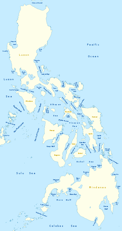
Deutsch: Karte der Seegewässer der Philippinen
English: Map of seas of the Philippines |
|
| തീയതി | ||
| സ്രോതസ്സ് | സ്വന്തം സൃഷ്ടി, using United States National Imagery and Mapping Agency data | |
| സ്രഷ്ടാവ് | NordNordWest | |
| അനുമതി (ഈ പ്രമാണത്തിന്റെ പുനരുപയോഗം) |
ഈ പ്രമാണത്തിന് അനുമതി നൽകപ്പെട്ടിരിക്കുന്നത് ക്രിയേറ്റീവ് കോമൺസ് ആട്രിബ്യൂഷൻ-ഷെയർ എലൈക് 3.0 ജർമ്മനി അനുവാദപത്ര പ്രകാരമാണ്.
 ഈ പ്രമാണത്തിന് അനുമതി നൽകപ്പെട്ടിരിക്കുന്നത് ക്രിയേറ്റീവ് കോമൺസ് ആട്രിബ്യൂഷൻ-ഷെയർ എലൈക് 3.0 അൺപോർട്ടഡ് അനുവാദപത്ര പ്രകാരമാണ്.
|
|
| മറ്റു പതിപ്പുകൾ |
|


|
This map has been made or improved in the German Kartenwerkstatt (Map Lab). You can propose maps to improve as well.
|
പ്രമാണ നാൾവഴി
ഏതെങ്കിലും തീയതി/സമയ കണ്ണിയിൽ ഞെക്കിയാൽ പ്രസ്തുതസമയത്ത് ഈ പ്രമാണം എങ്ങനെയായിരുന്നു എന്നു കാണാം.
| തീയതി/സമയം | ലഘുചിത്രം | അളവുകൾ | ഉപയോക്താവ് | അഭിപ്രായം | |
|---|---|---|---|---|---|
| നിലവിലുള്ളത് | 21:25, 14 ഫെബ്രുവരി 2011 | | 2,106 × 3,971 (517 കെ.ബി.) | NordNordWest | == {{int:filedesc}} == {{Information |Description= {{de|Karte der Seegewässer der Philippinen}} {{en|Map of seas of the Philippines}} |Source={{Own}}, using United States National Imagery and Mapping Agency data |Date=2012-02-14 |Author={{U|NordNordWest |
പ്രമാണത്തിന്റെ ഉപയോഗം
താഴെ കാണുന്ന 4 താളുകളിൽ ഈ ചിത്രം ഉപയോഗിക്കുന്നു:
പ്രമാണത്തിന്റെ ആഗോള ഉപയോഗം
താഴെ കൊടുത്തിരിക്കുന്ന മറ്റ് വിക്കികൾ ഈ പ്രമാണം ഉപയോഗിക്കുന്നു:
- de.wikipedia.org സംരംഭത്തിലെ ഉപയോഗം
- en.wikipedia.org സംരംഭത്തിലെ ഉപയോഗം
- South China Sea
- Luzon Strait
- Leyte Gulf
- Philippine Sea
- Canigao Channel
- Cebu Strait
- Sulu Sea
- Moro Gulf
- Davao Gulf
- Panay Gulf
- Bohol Sea
- Lingayen Gulf
- Surigao Strait
- Celebes Sea
- Sibuyan Sea
- Visayan Sea
- San Juanico Strait
- San Bernardino Strait
- Balintang Channel
- Camotes Sea
- Samar Sea
- Ragay Gulf
- Lagonoy Gulf
- Sorsogon Bay
- Albay Gulf
- Tablas Strait
- Mindoro Strait
- Balabac Strait
- Verde Island Passage
- Sibutu Passage
- Jintotolo Channel
- Tañon Strait
- Dinagat Sound
- Template:List of Philippine seas
- Iloilo Strait
- Guimaras Strait
- Basilan Strait
- Maqueda Channel
- Burias Pass
- Ticao Pass
- ilo.wikipedia.org സംരംഭത്തിലെ ഉപയോഗം
ഈ പ്രമാണത്തിന്റെ കൂടുതൽ ആഗോള ഉപയോഗം കാണുക.