കൊപാഹ്യൂ അഗ്നിപർവതം
| Copahue | |
|---|---|
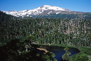
 Copahue's southwest face with Laguna Las Totoras in the foreground. | |
| ഉയരം കൂടിയ പർവതം | |
| Elevation | 2,997 m (9,833 ft) [1] |
| ഭൂമിശാസ്ത്രപരമായ പ്രത്യേകതകൾ | |
| സ്ഥാനം | Argentina and Chile |
| Parent range | Andes |
| ഭൂവിജ്ഞാനീയം | |
| Mountain type | Stratovolcano |
| Last eruption | 2013 (ongoing)[1] |
ചിലിയുടെയും അർജന്റീനയുടെയും തെക്കൻ പൊതു അതിർത്തിയിലാണ് കൊപാഹ്യൂ അഗ്നിപർവതം സ്ഥിതിചെയ്യുന്നത്. ആൻഡീസിലെ 2965 മീറ്റർ ഉയരമുള്ള കൊപാഹ്യൂ ഈ മേഖലയിലെ ഏറ്റവും സജീവമായ അഗ്നിപർവതങ്ങളിലൊന്നാണ്. 'കൊപാഹ്യൂ' എന്ന വാക്കിന് 'സൾഫർ ജലം' എന്നാണർത്ഥം.
2012 ഡിസംബറിലും,[2] 27 മേയ് 2013 നും അഗ്നിപർവതം തീ തുപ്പാൻ തുടങ്ങുന്നതായി ചിലി അതിജാഗ്രതാ നിർദ്ദേശം പുറപ്പെടുവിച്ചിരുന്നു.[3] ഇതോടെ സമീപപ്രദേശങ്ങളിലെ ആളുകളെ ഒഴിപ്പിക്കുകയുണ്ടായി. ഈ മേഖലയിലെ സജീവമായ അഗ്നിപർവ്വതങ്ങളിലൊന്നാണിത്.[4]
അവലംബം[തിരുത്തുക]
- ↑ 1.0 1.1 1.2 "Copahue". Global Volcanism Program. Smithsonian Institution. Retrieved 2005-02-11.
- ↑ "Chile and Argentina on alert over Copahue volcano eruption". BBC News. 23 December 2012.
- ↑ "കാപാഹ്യൂ അഗ്നിപർവതം പുക തുപ്പുന്നു; ചിലിയും അർജന്റീനയും ആയിരങ്ങളെ ഒഴിപ്പിച്ചു". മാതൃഭൂമി. 2013 മേയ് 28. Archived from the original on 2013-05-29. Retrieved 2013 മേയ് 28.
{{cite news}}: Check date values in:|accessdate=and|date=(help) - ↑ "ആർക്കൈവ് പകർപ്പ്". Archived from the original on 2013-05-29. Retrieved 2013-05-28.
അധിക വായനക്ക്[തിരുത്തുക]
- González-Ferrán, Oscar (1995). Volcanes de Chile. Santiago, Chile: Instituto Geográfico Militar. p. 640 pp. ISBN 956-202-054-1. (in Spanish; also includes volcanoes of Argentina, Bolivia, and Peru)
- Biggar, John (2005). The Andes: A Guide for Climbers (3rd ed.). Andes Publishing (Scotland). p. 304 pp. ISBN 0-9536087-2-7.

