ഓക്ലാന്റ് ദ്വീപ്
ദൃശ്യരൂപം
| Motu Maha (Māori) | |
|---|---|
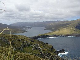
 Auckland Island, Carnley Harbour & Adams Island (RHS) | |
| Geography | |
| Coordinates | 50°41′S 166°05′E / 50.69°S 166.08°E |
| Archipelago | Auckland Islands |
| Area | 442.5[1] കി.m2 (170.9 ച മൈ) |
| Length | 42 km (26.1 mi) |
| Width | 26 km (16.2 mi) |
| Highest elevation | 659 m (2,162 ft) |
| Highest point | Cavern Peak |
| Administration | |
New Zealand | |
ഓക്ലാന്റ് ദ്വീപ്, ന്യൂസിലാന്റിന്റെ കീഴിലുള്ള ജനവാസമില്ലാത്ത തെക്കൻ പസഫിക് സമുദ്രത്തിലെ ഓക്ലാന്റ് ദ്വീപസമൂഹത്തിലെ പ്രധാന ദ്വീപായ ഉപദ്വീപ് ആണ്. ഈ ദ്വീപ് മറ്റു അന്റാർക്ടിക്കിനടുത്തുള്ള ദ്വീപുകളെപ്പോലെ ലോകപൈതൃകപ്പട്ടികയിലുള്ള ദ്വീപാണ്. [2]
ഇതും കാണൂ
[തിരുത്തുക]- Composite Antarctic Gazetteer
- List of Antarctic and subantarctic islands
- List of islands of New Zealand
- New Zealand subantarctic islands
- SCAR
- Territorial claims in Antarctica
അവലംബം
[തിരുത്തുക]- ↑ "Auckland - including Dundas, Ewing, Rose". Islands.unep.ch. Archived from the original on 2020-02-19. Retrieved 1 August 2010.
- ↑ UNESCO World Heritage list together with the other subantarctic New Zealand islands in the region as follows: 877-004 Auckland Isls, New Zealand S50.29 E165.52 62560Ha 1998

