
പ്രമാണം:Cheshire outline map with UK.png
കൂടുതൽ വ്യക്തതയുള്ള ചിത്രം ലഭ്യമല്ല.
Cheshire_outline_map_with_UK.png (722 × 552 പിക്സൽ, പ്രമാണത്തിന്റെ വലിപ്പം: 412 കെ.ബി., മൈം തരം: image/png)
| ഈ പ്രമാണം വിക്കിമീഡിയ കോമൺസിൽ നിന്നുള്ളതാണ്. പ്രമാണത്തെക്കുറിച്ചുള്ള വിവരണം താഴെ കൊടുത്തിരിക്കുന്നു.
|
ചുരുക്കം
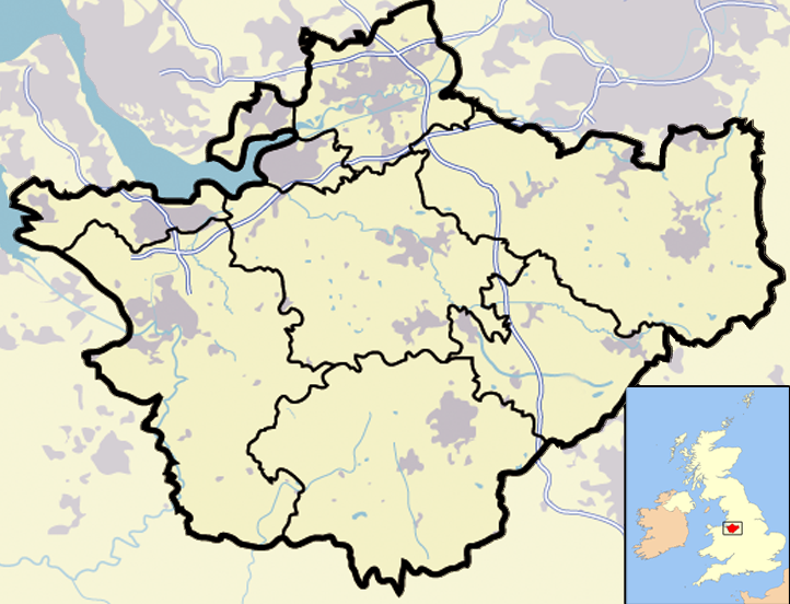
| വിവരണം | Map of en:Cheshire and surrounding area, with micromap of the British Isles for context. Urban areas are shown in grey, water bodies in light-blue, motorways in blue with white stripe and county and borough boundaries in black. |
| തീയതി | 29 മാർച്ച് 2007 (യഥാർത്ഥ അപ്ലോഡ് തീയതി) |
| സ്രോതസ്സ് | en.wikipedia പദ്ധതിയിൽ നിന്നും കോമൺസിലേയ്ക്ക് മാറ്റിയത്. |
| സ്രഷ്ടാവ് | ഇംഗ്ലീഷ് വിക്കിപീഡിയ പദ്ധതിയിലെ Jhamez84 |
| മറ്റു പതിപ്പുകൾ |
.png) (for boundaries expected to come into effect for 2009). (for boundaries expected to come into effect for 2009). |
അനുമതി
| ഈ സൃഷ്ടി അതിന്റെ സ്രഷ്ടാവായ ഇംഗ്ലീഷ് വിക്കിപീഡിയ പദ്ധതിയിലെ Jhamez84, സ്വയം പൊതുസഞ്ചയത്തിൽ പ്രസിദ്ധീകരിച്ചിരിക്കുന്നു. ഇത് ആഗോള വ്യാപകമായി ബാധകമാണ്. ചില രാജ്യങ്ങളിൽ ഇത് നിയമപ്രകാരം സാദ്ധ്യമല്ലെന്ന് വന്നേക്കാം; അങ്ങനെയെങ്കിൽ: ഈ സൃഷ്ടി, നിയമപ്രകാരം നിബന്ധനകൾ ഉണ്ടെങ്കിൽ അവയൊഴിച്ച്, യാതൊരു നിബന്ധനകളും ഇല്ലാതെ ഏതൊരാൾക്കും ഏതൊരു ഉപയോഗത്തിനും, ഉപയോഗപ്പെടുത്തുവാൻ Jhamez84 അനുവദിച്ചിരിക്കുന്നു. |
യഥാർത്ഥ അപ്ലോഡ് രേഖ
ഈ ചിത്രം ആദ്യം അപ്ലോഡ് ചെയ്തത് ഇവിടെ കാണാം. താഴെയുള്ള എല്ലാ ഉപയോക്തൃനാമവും ഉള്ളത് en.wikipedia സംരംഭത്തിൽ ആണ്.
- 2007-04-11 23:50 Jhamez84 722×552×8 (421996 bytes) correcting positioning of some urban areas (they were too east-northeasterly)
- 2007-04-11 17:14 Jhamez84 722×552×8 (420187 bytes) fixing issues in and around the [[M6 motorway]] (moving it to the west per discussion)
- 2007-04-11 00:38 Jhamez84 722×552×8 (438177 bytes) Much more detailed (and thus hopefully more accurate) version of the [[Cheshire]] map.
- 2007-03-29 23:48 Jhamez84 800×558×8 (446798 bytes) Map of [[Cheshire]] and surrounding area, with micromap of the British Isles for context. Urban areas are shown in grey, water bodies in light-blue, motorways in blue with white stripe and county and borough boundaries in black.
പ്രമാണ നാൾവഴി
ഏതെങ്കിലും തീയതി/സമയ കണ്ണിയിൽ ഞെക്കിയാൽ പ്രസ്തുതസമയത്ത് ഈ പ്രമാണം എങ്ങനെയായിരുന്നു എന്നു കാണാം.
| തീയതി/സമയം | ലഘുചിത്രം | അളവുകൾ | ഉപയോക്താവ് | അഭിപ്രായം | |
|---|---|---|---|---|---|
| നിലവിലുള്ളത് | 13:02, 23 ജൂൺ 2008 | | 722 × 552 (412 കെ.ബി.) | Jza84 | removed erroneous urban area |
| 20:55, 29 ജൂൺ 2007 |  | 722 × 552 (412 കെ.ബി.) | Pit-yacker | {{Information |Description=Map of en:Cheshire and surrounding area, with micromap of the British Isles for context. Urban areas are shown in grey, water bodies in light-blue, motorways in blue with white stripe and county and borough boundaries in bl |
പ്രമാണത്തിന്റെ ഉപയോഗം
താഴെ കാണുന്ന താളിൽ ഈ ചിത്രം ഉപയോഗിക്കുന്നു:
പ്രമാണത്തിന്റെ ആഗോള ഉപയോഗം
താഴെ കൊടുത്തിരിക്കുന്ന മറ്റ് വിക്കികൾ ഈ പ്രമാണം ഉപയോഗിക്കുന്നു:
- ar.wikipedia.org സംരംഭത്തിലെ ഉപയോഗം
- ceb.wikipedia.org സംരംഭത്തിലെ ഉപയോഗം
- en.wikipedia.org സംരംഭത്തിലെ ഉപയോഗം
- eo.wikipedia.org സംരംഭത്തിലെ ഉപയോഗം
- ga.wikipedia.org സംരംഭത്തിലെ ഉപയോഗം
- pt.wikipedia.org സംരംഭത്തിലെ ഉപയോഗം
- ro.wikipedia.org സംരംഭത്തിലെ ഉപയോഗം
- sv.wikipedia.org സംരംഭത്തിലെ ഉപയോഗം
- tt.wikipedia.org സംരംഭത്തിലെ ഉപയോഗം
- uk.wikipedia.org സംരംഭത്തിലെ ഉപയോഗം
- www.wikidata.org സംരംഭത്തിലെ ഉപയോഗം