
പ്രമാണം:Asia 1200ad.jpg

ഈ പ്രിവ്യൂവിന്റെ വലിപ്പം: 800 × 494 പിക്സലുകൾ. മറ്റ് റെസലൂഷനുകൾ: 320 × 198 പിക്സലുകൾ | 640 × 395 പിക്സലുകൾ | 1,024 × 632 പിക്സലുകൾ | 1,280 × 790 പിക്സലുകൾ | 1,968 × 1,215 പിക്സലുകൾ.
പൂർണ്ണ വലിപ്പം (1,968 × 1,215 പിക്സൽ, പ്രമാണത്തിന്റെ വലിപ്പം: 731 കെ.ബി., മൈം തരം: image/jpeg)
| ഈ പ്രമാണം വിക്കിമീഡിയ കോമൺസിൽ നിന്നുള്ളതാണ്. പ്രമാണത്തെക്കുറിച്ചുള്ള വിവരണം താഴെ കൊടുത്തിരിക്കുന്നു.
|
ചുരുക്കം

|
ഈ historical map ചിത്രം വെക്റ്റർ ഗ്രാഫിക്സ് ഉപയോഗിച്ച് എസ്.വി.ജി. പ്രമാണമായി പുനർനിർമ്മിക്കേണ്ടതാണ്. അങ്ങനെ ചെയ്യുന്നതുകൊണ്ട് പല ഗുണങ്ങളുമുണ്ട്; കൂടുതൽ വിവരങ്ങൾക്ക് മെച്ചപ്പെടുത്തുവാനുള്ള മീഡിയകൾ കാണുക. ഈ ചിത്രത്തിന്റെ എസ്.വി.ജി. പതിപ്പ് കൈവശമുണ്ടെങ്കിൽ ദയവായി അപ്ലോഡ് ചെയ്യുക. അപ്ലോഡ് ചെയ്ത ശേഷം ഈ ഫലകം {{vector version available|പുതിയ ചിത്രത്തിന്റെ പേര്.svg}} എന്ന് മാറ്റിച്ചേർക്കുക.
|


| വിവരണം |
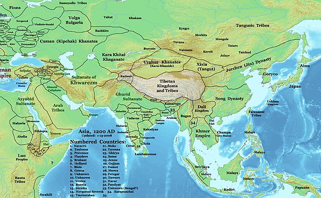
English: This image is a zoomed-in version of Eastern Hemisphere in 1200 AD updated 2008 (not correct).
Author: Thomas A. Lessman. Source URL: http://www.ThomasLessman.com/History/images/East-Hem_1200ad.jpg. Image was created by me (Thomas Lessman) based on map of Eastern Hemisphere in 1200AD. Image is free for public and/or educational use. I would appreciate a mention if this image is used elsewhere. If anyone is interested in helping further this work, please contact Thomas Lessman at talessman@yis.us. |
| തീയതി | 3 ഡിസംബർ 2007 (യഥാർത്ഥ അപ്ലോഡ് തീയതി) |
| സ്രോതസ്സ് | en.wikipedia പദ്ധതിയിൽ നിന്നും കോമൺസിലേയ്ക്ക് ഉപയോക്താവ് Undead_warrior മാറ്റിയത്. |
| സ്രഷ്ടാവ് | ഇംഗ്ലീഷ് വിക്കിപീഡിയ പദ്ധതിയിലെ Talessman |
അനുമതി
ഈ സൃഷ്ടിയുടെ പകർപ്പവകാശ ഉടമയായ ഇംഗ്ലീഷ് വിക്കിപീഡിയ പദ്ധതിയിലെ Talessman, താഴെ പറയുന്ന അനുമതികളിൽ ഈ സൃഷ്ടി ഇതിനാൽ പ്രസിദ്ധീകരിച്ചിരിക്കുന്നു:

|
സ്വതന്ത്ര സോഫ്റ്റ്വേർ സമിതി പ്രസിദ്ധീകരിച്ചിട്ടുള്ള ഗ്നു സ്വതന്ത്ര പ്രമാണ അനുവാദപത്രം പതിപ്പ് 1.2 അല്ലെങ്കിൽ പുതിയ പതിപ്പുകൾ പ്രകാരം; മാറ്റമില്ലാത്ത ഭാഗങ്ങളില്ലാതെ, മുൻചട്ടയിലെ എഴുത്തുകൾ ഇല്ലാതെ, പിൻചട്ടയിലെ എഴുത്തുകൾ ഇല്ലാതെ പകർത്താനും, വിതരണം ചെയ്യാനും ഒപ്പം/അല്ലെങ്കിൽ ഈ പ്രമാണത്തിൽ മാറ്റം വരുത്തുവാനും ഉള്ള അവകാശങ്ങൾ നൽകുന്നു. ഗ്നു സ്വതന്ത്ര പ്രമാണ അനുവാദപത്രം എന്ന തലക്കെട്ടിൽ അനുവാദപത്രത്തിന്റെ ഒരു പകർപ്പ് ഉൾപ്പെടുത്തിയിട്ടുണ്ട്. |
ഈ പ്രമാണത്തിന് അനുമതി നൽകപ്പെട്ടിരിക്കുന്നത് ക്രിയേറ്റീവ് കോമൺസ് ആട്രിബ്യൂഷൻ 3.0 അൺപോർട്ടഡ് അനുവാദപത്ര പ്രകാരമാണ്.
കടപ്പാട്: ഇംഗ്ലീഷ് വിക്കിപീഡിയ പദ്ധതിയിലെ Talessman
- താങ്കൾക്കുള്ള സ്വാതന്ത്ര്യങ്ങൾ:
- പങ്ക് വെയ്ക്കൽ – കൃതി പകർത്താനും, വിതരണം ചെയ്യാനും, പ്രസരിപ്പിക്കാനും
- പുനഃമിശ്രണം ചെയ്യൽ – കൃതി അനുയുക്തമാക്കാൻ
- താഴെ പറയുന്ന ഉപാധികൾ പാലിക്കുക:
- കടപ്പാട് – രചയിതാവോ അനുമതിയുള്ളയാളോ വ്യക്തമാക്കിയിട്ടുള്ള വിധത്തിൽ കൃതിയ്ക്കുള്ള കടപ്പാട് താങ്കൾ നൽകിയിരിക്കണം. താങ്കൾക്കിത് ഏത് വിധത്തിൽ വേണമെങ്കിലും ചെയ്യാവുന്നതാണ്, പക്ഷേ അത് അവർ താങ്കളേയോ താങ്കളുടെ ഉപയോഗത്തേയോ അടിച്ചേൽപ്പിച്ചതു പോലെയാവരുത്.
താങ്കൾക്ക് താങ്കളുടെ ഇച്ഛാനുസരണം അനുമതി തിരഞ്ഞെടുക്കാം.
യഥാർത്ഥ അപ്ലോഡ് രേഖ
ഈ ചിത്രം ആദ്യം അപ്ലോഡ് ചെയ്തത് ഇവിടെ കാണാം. താഴെയുള്ള എല്ലാ ഉപയോക്തൃനാമവും ഉള്ളത് en.wikipedia സംരംഭത്തിൽ ആണ്.
- 2008-01-14 21:32 Talessman 1968×1215×8 (748875 bytes) Minor corrections based on info from DK Atlas of World History and other sources.
- 2008-01-11 21:51 Talessman 2076×1181×8 (764936 bytes) Fixed borders of central asia, India, southeast Asia, Indonesia, and Africa. Added more information.
- 2007-12-03 20:14 Talessman 2043×1308×8 (789102 bytes) This image is a zoomed-in version of [http://en.wikipedia.org/wiki/Image:East-Hem_1200ad.jpg Eastern Hemisphere in 1200 AD]. [[Image:East-Hem_1200ad.jpg|thumb|300px|left|Eastern Hemisphere in 1200 AD.]] Author: Thomas A. Lessman. Source URL: http://www.
പ്രമാണ നാൾവഴി
ഏതെങ്കിലും തീയതി/സമയ കണ്ണിയിൽ ഞെക്കിയാൽ പ്രസ്തുതസമയത്ത് ഈ പ്രമാണം എങ്ങനെയായിരുന്നു എന്നു കാണാം.
| തീയതി/സമയം | ലഘുചിത്രം | അളവുകൾ | ഉപയോക്താവ് | അഭിപ്രായം | |
|---|---|---|---|---|---|
| നിലവിലുള്ളത് | 04:32, 25 മാർച്ച് 2008 | | 1,968 × 1,215 (731 കെ.ബി.) | Undead warrior | {{Information |Description={{en|This image is a zoomed-in version of [http://en.wikipedia.org/wiki/Image:East-Hem_1200ad.jpg Eastern Hemisphere in 1200 AD]. thumb|300px|left|Eastern Hemisphere in 1200 AD. Author: Thomas |
പ്രമാണത്തിന്റെ ഉപയോഗം
താഴെ കാണുന്ന 2 താളുകളിൽ ഈ ചിത്രം ഉപയോഗിക്കുന്നു:
പ്രമാണത്തിന്റെ ആഗോള ഉപയോഗം
താഴെ കൊടുത്തിരിക്കുന്ന മറ്റ് വിക്കികൾ ഈ പ്രമാണം ഉപയോഗിക്കുന്നു:
- an.wikipedia.org സംരംഭത്തിലെ ഉപയോഗം
- ar.wikipedia.org സംരംഭത്തിലെ ഉപയോഗം
- ast.wikipedia.org സംരംഭത്തിലെ ഉപയോഗം
- ba.wikipedia.org സംരംഭത്തിലെ ഉപയോഗം
- bn.wikipedia.org സംരംഭത്തിലെ ഉപയോഗം
- bs.wikipedia.org സംരംഭത്തിലെ ഉപയോഗം
- ca.wikipedia.org സംരംഭത്തിലെ ഉപയോഗം
- ceb.wikipedia.org സംരംഭത്തിലെ ഉപയോഗം
- de.wikipedia.org സംരംഭത്തിലെ ഉപയോഗം
- el.wikipedia.org സംരംഭത്തിലെ ഉപയോഗം
- en.wikipedia.org സംരംഭത്തിലെ ഉപയോഗം
- eo.wikipedia.org സംരംഭത്തിലെ ഉപയോഗം
- es.wikipedia.org സംരംഭത്തിലെ ഉപയോഗം
- fa.wikipedia.org സംരംഭത്തിലെ ഉപയോഗം
ഈ പ്രമാണത്തിന്റെ കൂടുതൽ ആഗോള ഉപയോഗം കാണുക.