പ്രമാണം:WestBengalDistricts numbered.svg

Page contents not supported in other languages.
വിക്കിപീഡിയ, ഒരു സ്വതന്ത്ര വിജ്ഞാനകോശം.

പൂർണ്ണ വലിപ്പം(എസ്.വി.ജി. പ്രമാണം, നാമമാത്രമായ 768 × 1,159 പിക്സലുകൾ, പ്രമാണത്തിന്റെ വലിപ്പം: 311 കെ.ബി.)

ചുരുക്കം

വിവരണം
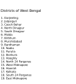
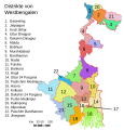
English: Original summary by creator of base svg file deeptrivia. Districts of West Bengal

Based on https://web.archive.org/web/20040606103522/www.censusindia.net/results/2001maps/wbengal01.html

Modifications by Mouryan:

  1. upladed translated version of File:WestBengalDistricts numbered de.svg.
  2. The districts of Dakshin 24 Parganas district and Uttar 24 Parganas were incorrectly numbered in the Map. The errors have been rectified.

Modifications by Furfur:

  1. The 4 (four) new districts of West Bengal namely Paschim Bardhaman district (bifurcated from Bardhaman district), Kalimpong district (bifurcated from Darjeeling district), Alipurduar district (bifurcated from Jalpaiguri district) and Jhargram district (bifurcated from Paschim Medinipur district) has been shown in this new Updated map.

Modifications by Antorjal:

  1. Midnapore District has been bifurcated to show both Paschim Medinipur and Purba Medinipur.
  2. Numbered and listed districts per comments at peer-review.
  3. Font size reduced for clarity, since the districts are now listed.
  4. Many of the spellings did not conform to linked articles in the text. All spellings now match the West Bengal article spellings.
തീയതി 8 ഒക്ടോബർ 2006 (യഥാർത്ഥ അപ്‌ലോഡ് തീയതി)
സ്രോതസ്സ് en.wikipedia പദ്ധതിയിൽ നിന്നും കോമൺസിലേയ്ക്ക് ഉപയോക്താവ് Padawane മാറ്റിയത്.
സ്രഷ്ടാവ് ഇംഗ്ലീഷ് വിക്കിപീഡിയ പദ്ധതിയിലെ Antorjal ആയിരുന്നു യഥാർത്ഥ അപ്‌ലോഡർ
മറ്റു പതിപ്പുകൾ

[തിരുത്തുക]

SVG വികസനം
InfoField
 
എസ്.വി.ജി.യുടെ സ്രോതസ്സ് കോഡ് അസാധു ആണ് കാരണം അതിൽ ഒരു പിഴവ് ഉണ്ട്.
 
വെക്റ്റർ ചിത്രം സൃഷ്ടിച്ചത് Adobe Illustrator ഉപയോഗിച്ചാണ്,
 
and with Inkscape.
 
 This map uses embedded text that can be easily translated using a text editor.

അനുമതി

w:ml:ക്രിയേറ്റീവ് കോമൺസ്
കടപ്പാട് ഇതു പോലെ പങ്ക് വെയ്ക്കുക
ഈ പ്രമാണത്തിന് അനുമതി നൽകപ്പെട്ടിരിക്കുന്നത് ക്രിയേറ്റീവ് കോമൺസ് ആട്രിബ്യൂഷൻ-ഷെയർ എലൈക് 2.5 സാമാന്യ, 2.0 സാമാന്യ ഒപ്പം 1.0 സാമാന്യ അനുവാദപത്രങ്ങൾ പ്രകാരമാണ്.
താങ്കൾക്കുള്ള സ്വാതന്ത്ര്യങ്ങൾ:
  • പങ്ക് വെയ്ക്കൽ – കൃതി പകർത്താനും, വിതരണം ചെയ്യാനും, പ്രസരിപ്പിക്കാനും
  • പുനഃമിശ്രണം ചെയ്യൽ – കൃതി അനുയുക്തമാക്കാൻ
താഴെ പറയുന്ന ഉപാധികൾ പാലിക്കുക:
  • കടപ്പാട് – രചയിതാവോ അനുമതിയുള്ളയാളോ വ്യക്തമാക്കിയിട്ടുള്ള വിധത്തിൽ കൃതിയ്ക്കുള്ള കടപ്പാട് താങ്കൾ നൽകിയിരിക്കണം. താങ്കൾക്കിത് ഏത് വിധത്തിൽ വേണമെങ്കിലും ചെയ്യാവുന്നതാണ്, പക്ഷേ അത് അവർ താങ്കളേയോ താങ്കളുടെ ഉപയോഗത്തേയോ അടിച്ചേൽപ്പിച്ചതു പോലെയാവരുത്.
  • ഇതു പോലെ പങ്ക് വെയ്ക്കുക – ഈ സൃഷ്ടിയെ പുനഃമിശ്രണം ചെയ്തോ രൂപാന്തരപ്പെടുത്തിയോ അടിസ്ഥാനപ്പെടുത്തിയോ ഉണ്ടാക്കുന്നവ; താങ്കളുടെ സംഭാവനയടക്കമുള്ള സൃഷ്ടി യഥാർത്ഥ സൃഷ്ടിയുടെ അതേ അല്ലെങ്കിൽ അനുരൂപമായ ഉപയോഗാനുമതിയിൽ മാത്രമേ താങ്കൾ വിതരണം ചെയ്യാവൂ.
w:ml:ക്രിയേറ്റീവ് കോമൺസ്
കടപ്പാട് ഇതു പോലെ പങ്ക് വെയ്ക്കുക
ഈ പ്രമാണത്തിന് അനുമതി നൽകപ്പെട്ടിരിക്കുന്നത് ക്രിയേറ്റീവ് കോമൺസ് ആട്രിബ്യൂഷൻ-ഷെയർ എലൈക് 3.0 അൺപോർട്ടഡ് അനുവാദപത്ര പ്രകാരമാണ്. ബാദ്ധ്യതാനിരാകരണങ്ങൾക്ക് വിധേയം.
താങ്കൾക്കുള്ള സ്വാതന്ത്ര്യങ്ങൾ:
  • പങ്ക് വെയ്ക്കൽ – കൃതി പകർത്താനും, വിതരണം ചെയ്യാനും, പ്രസരിപ്പിക്കാനും
  • പുനഃമിശ്രണം ചെയ്യൽ – കൃതി അനുയുക്തമാക്കാൻ
താഴെ പറയുന്ന ഉപാധികൾ പാലിക്കുക:
  • കടപ്പാട് – രചയിതാവോ അനുമതിയുള്ളയാളോ വ്യക്തമാക്കിയിട്ടുള്ള വിധത്തിൽ കൃതിയ്ക്കുള്ള കടപ്പാട് താങ്കൾ നൽകിയിരിക്കണം. താങ്കൾക്കിത് ഏത് വിധത്തിൽ വേണമെങ്കിലും ചെയ്യാവുന്നതാണ്, പക്ഷേ അത് അവർ താങ്കളേയോ താങ്കളുടെ ഉപയോഗത്തേയോ അടിച്ചേൽപ്പിച്ചതു പോലെയാവരുത്.
  • ഇതു പോലെ പങ്ക് വെയ്ക്കുക – ഈ സൃഷ്ടിയെ പുനഃമിശ്രണം ചെയ്തോ രൂപാന്തരപ്പെടുത്തിയോ അടിസ്ഥാനപ്പെടുത്തിയോ ഉണ്ടാക്കുന്നവ; താങ്കളുടെ സംഭാവനയടക്കമുള്ള സൃഷ്ടി യഥാർത്ഥ സൃഷ്ടിയുടെ അതേ അല്ലെങ്കിൽ അനുരൂപമായ ഉപയോഗാനുമതിയിൽ മാത്രമേ താങ്കൾ വിതരണം ചെയ്യാവൂ.
ജി.എഫ്.ഡി.എൽ. അനുവാദപത്രത്തിന്റെ അനുമതി പുതുക്കലിന്റെ ഭാഗമായാണ് ഈ ടാഗ് ചേർക്കപ്പെട്ടിരിക്കുന്നത്.
GNU head സ്വതന്ത്ര സോഫ്റ്റ്‌‌വേർ സമിതി പ്രസിദ്ധീകരിച്ചിട്ടുള്ള ഗ്നു സ്വതന്ത്ര പ്രമാണ അനുവാദപത്രം പതിപ്പ് 1.2 അല്ലെങ്കിൽ പുതിയ പതിപ്പുകൾ പ്രകാരം; മാറ്റമില്ലാത്ത ഭാഗങ്ങളില്ലാതെ, മുൻചട്ടയിലെ എഴുത്തുകൾ ഇല്ലാതെ, പിൻചട്ടയിലെ എഴുത്തുകൾ ഇല്ലാതെ പകർത്താനും, വിതരണം ചെയ്യാനും ഒപ്പം/അല്ലെങ്കിൽ ഈ പ്രമാണത്തിൽ മാറ്റം വരുത്തുവാനും ഉള്ള അവകാശങ്ങൾ നൽകുന്നു. ഗ്നു സ്വതന്ത്ര പ്രമാണ അനുവാദപത്രം എന്ന തലക്കെട്ടിൽ അനുവാദപത്രത്തിന്റെ ഒരു പകർപ്പ് ഉൾപ്പെടുത്തിയിട്ടുണ്ട്. ബാദ്ധ്യതാനിരാകരണങ്ങൾക്ക് വിധേയം.

യഥാർത്ഥ അപ്‌‌ലോഡ് രേഖ

ഈ ചിത്രം ആദ്യം അപ്‌ലോഡ് ചെയ്തത് ഇവിടെ കാണാം. താഴെയുള്ള എല്ലാ ഉപയോക്തൃനാമവും ഉള്ളത് en.wikipedia സംരംഭത്തിൽ ആണ്.
  • 2006-12-25 04:28 Deeptrivia 450×500×0 (102714 bytes) Repair attempt
  • 2006-12-25 04:17 Deeptrivia 450×500×0 (101044 bytes) Repair attempt
  • 2006-10-08 14:21 Antorjal 450×500×0 (100501 bytes) Original summary by creator of base svg file [[User:deeptrivia|deeptrivia]]. Districts of West Bengal Based on http://web.archive.org/web/20040606103522/www.censusindia.net/results/2001maps/wbengal01.html Modifications by [[User:Antorjal|An
  • 2006-10-08 14:17 Antorjal 450×500×0 (100294 bytes) Original summary by creator of base svg file [[User:deeptrivia|deeptrivia]]. Districts of West Bengal Based on http://web.archive.org/web/20040606103522/www.censusindia.net/results/2001maps/wbengal01.html Modifications by [[User:Antorjal|An
  • 2006-10-08 14:15 Antorjal 450×500×0 (100501 bytes) Original summary by creator of base svg file [[User:deeptrivia|deeptrivia]]. Districts of West Bengal Based on http://web.archive.org/web/20040606103522/www.censusindia.net/results/2001maps/wbengal01.html Modifications by [[User:Antorjal|An
  • 2006-10-08 14:09 Antorjal 450×500×0 (100484 bytes) Original summary by creator of base svg file [[User:deeptrivia|deeptrivia]]. Districts of West Bengal Based on http://web.archive.org/web/20040606103522/www.censusindia.net/results/2001maps/wbengal01.html Modifications by [[User:Antorjal|An
  • 2006-10-08 14:05 Antorjal 450×500×0 (100501 bytes) Original summary by creator of base svg file [[User:deeptrivia|deeptrivia]]. Districts of West Bengal Based on http://web.archive.org/web/20040606103522/www.censusindia.net/results/2001maps/wbengal01.html Modifications by [[User:Antorjal|An

തലവാചകങ്ങൾ

ഈ പ്രമാണം എന്തിനെ പ്രതിനിധീകരിക്കുന്നുവെന്ന ഒറ്റവരി വിശദീകരണം ചേർക്കുക
Map of West Bengal

ഈ പ്രമാണത്തിൽ ചിത്രീകരിച്ചിരിക്കുന്ന ഇനങ്ങൾ

സൃഷ്ടിയിലുള്ളത്

8 ഒക്ടോബർ 2006

പ്രമാണ നാൾവഴി

ഏതെങ്കിലും തീയതി/സമയ കണ്ണിയിൽ ഞെക്കിയാൽ പ്രസ്തുതസമയത്ത് ഈ പ്രമാണം എങ്ങനെയായിരുന്നു എന്നു കാണാം.

തീയതി/സമയംലഘുചിത്രംഅളവുകൾഉപയോക്താവ്അഭിപ്രായം
നിലവിലുള്ളത്21:04, 25 ഏപ്രിൽ 202021:04, 25 ഏപ്രിൽ 2020-ലെ പതിപ്പിന്റെ ലഘുചിത്രം768 × 1,159 (311 കെ.ബി.)Debjitpaul10Updated text
20:45, 25 ഏപ്രിൽ 202020:45, 25 ഏപ്രിൽ 2020-ലെ പതിപ്പിന്റെ ലഘുചിത്രം768 × 1,159 (113 കെ.ബി.)Debjitpaul10Uploaded a corrected and transparent version.
06:15, 5 നവംബർ 201706:15, 5 നവംബർ 2017-ലെ പതിപ്പിന്റെ ലഘുചിത്രം576 × 601 (144 കെ.ബി.)Mouryan{{Information |Description={{en|Original summary by creator of base svg file deeptrivia. Districts of West Bengal Based on http://web.archive.org/web/20040606103522/www.censusindia.net/results/2001maps/wbengal01.html Modificati...
02:51, 5 നവംബർ 201702:51, 5 നവംബർ 2017-ലെ പതിപ്പിന്റെ ലഘുചിത്രം576 × 601 (144 കെ.ബി.)Mouryan{{Information |Description={{en|Original summary by creator of base svg file deeptrivia. Districts of West Bengal Based on http://web.archive.org/web/20040606103522/www.censusindia.net/results/2001maps/wbengal01.html Modificati...
13:59, 25 നവംബർ 200813:59, 25 നവംബർ 2008-ലെ പതിപ്പിന്റെ ലഘുചിത്രം1,595 × 2,256 (212 കെ.ബി.)GDibyendu{{Information |Description=fixed map (sunderbans), fixed district names |Source=based on locator map:West_Bengal_locator_map.svg |Date=2008-11-25 |Author=GDibyendu |Permission=All |other_versions= }}
20:30, 24 നവംബർ 200820:30, 24 നവംബർ 2008-ലെ പതിപ്പിന്റെ ലഘുചിത്രം450 × 500 (100 കെ.ബി.)GDibyenduReverted to version as of 14:58, 17 January 2008 as some error crept in today's attempted upload
20:14, 24 നവംബർ 200820:14, 24 നവംബർ 2008-ലെ പതിപ്പിന്റെ ലഘുചിത്രം1,595 × 2,256 (191 കെ.ബി.)GDibyendu{{Information |Description=Corrected the map (it was not showing sunderbans are properly) |Source=This map is based on locator map of West Bengal (West_Bengal_locator_map.svg) |Date=2008-11-24 |Author=GDibyendu |Permission=All |other_versions= }}
17:43, 22 നവംബർ 200817:43, 22 നവംബർ 2008-ലെ പതിപ്പിന്റെ ലഘുചിത്രം450 × 500 (100 കെ.ബി.)GDibyenduReverted to version as of 14:58, 17 January 2008
17:41, 22 നവംബർ 200817:41, 22 നവംബർ 2008-ലെ പതിപ്പിന്റെ ലഘുചിത്രം450 × 500 (7 കെ.ബി.)GDibyendu{{Information |Description=Rewrote text in image to improve readability |Source=Based on last version |Date=2008-11-22 |Author=GDibyendu |Permission=All |other_versions= }}
14:58, 17 ജനുവരി 200814:58, 17 ജനുവരി 2008-ലെ പതിപ്പിന്റെ ലഘുചിത്രം450 × 500 (100 കെ.ബി.)File Upload Bot (Magnus Manske) {{BotMoveToCommons|en.wikipedia}} {{Information |Description={{en|Original summary by creator of base svg file deeptrivia. Districts of West Bengal Based on http://web.archive.org/web/20040606103522/www.censusindia.net/results/200

താഴെ കാണുന്ന താളിൽ ഈ ചിത്രം ഉപയോഗിക്കുന്നു:

പ്രമാണത്തിന്റെ ആഗോള ഉപയോഗം

താഴെ കൊടുത്തിരിക്കുന്ന മറ്റ് വിക്കികൾ ഈ പ്രമാണം ഉപയോഗിക്കുന്നു:

ഈ പ്രമാണത്തിന്റെ കൂടുതൽ ആഗോള ഉപയോഗം കാണുക.

മെറ്റാഡാറ്റ

"https://ml.wikipedia.org/wiki/പ്രമാണം:WestBengalDistricts_numbered.svg" എന്ന താളിൽനിന്ന് ശേഖരിച്ചത്