
പ്രമാണം:Russian Empire (orthographic projection).svg

ഈ SVG പ്രമാണത്തിന്റെ PNG പ്രിവ്യൂവിന്റെ വലിപ്പം: 541 × 541 പിക്സലുകൾ. മറ്റ് റെസലൂഷനുകൾ: 240 × 240 പിക്സലുകൾ | 480 × 480 പിക്സലുകൾ | 768 × 768 പിക്സലുകൾ | 1,024 × 1,024 പിക്സലുകൾ | 2,048 × 2,048 പിക്സലുകൾ.
പൂർണ്ണ വലിപ്പം (എസ്.വി.ജി. പ്രമാണം, നാമമാത്രമായ 541 × 541 പിക്സലുകൾ, പ്രമാണത്തിന്റെ വലിപ്പം: 393 കെ.ബി.)
| ഈ പ്രമാണം വിക്കിമീഡിയ കോമൺസിൽ നിന്നുള്ളതാണ്. പ്രമാണത്തെക്കുറിച്ചുള്ള വിവരണം താഴെ കൊടുത്തിരിക്കുന്നു.
|
ചുരുക്കം
| വിവരണം |
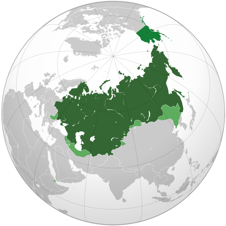
English: Russian Empire.
Territories (1914). Other territories that have ever been part of Russian Empire. Spheres of influence. Former spheres. Deutsch: Russisches Reich.
Gebiete (1914). Andere Gebiete, die jemals Teil des russischen Reiches waren. Einflussbereiche. Español: Imperio ruso.
Territorios (1914). Otros territorios que alguna vez han sido parte del Imperio ruso. Esferas de influencia. Français : Empire russe.
Territoires (1914). Autres territoires ayant fait partie de l'empire russe à un moment donné. Sphères d'influence. Italiano: Impero russo.
Territori (1914). Altri territori che hanno fatto parte dell'Impero russo. Sfera di influenza. Polski: Imperium Rosyjskie.
Terytorium (1914). Inne terytoria, które kiedyś były częścią Imperium Rosyjskiego. Strefy wpływów. Português: Império Russo.
Territórios (1914). Outros territórios que já fizeram parte do Império Russo. Esfera de influência. Русский: Российская империя.
Территории (1914). Другие территории, которые когда-либо были частью Российской империи. Сферы влияния. Бывшие сферы влияния. Українська: Російська імперія. Території станом на 1914 рік. Інші території, які будь-коли входили до складу Російської імперії. Сфери впливу. Колишні сфери впливу. |
| തീയതി | |
| സ്രോതസ്സ് | സ്വന്തം സൃഷ്ടി |
| സ്രഷ്ടാവ് | Milenioscuro |
| മറ്റു പതിപ്പുകൾ |
.svg) |
.svg)

.svg)
.svg)
.svg)
.svg)
.svg)
.svg)
.svg)
.svg)
.svg)
.svg)
.svg)
.svg)
.svg)
.svg)
.svg)
.svg)
.svg)
.svg)
.svg)
.svg)
.svg)
.svg)
.svg)
.svg)
.svg)
.svg)
.svg)
.svg)
.svg)
.svg)
.svg)
.svg)
.svg)
.svg)
.svg)
.svg)
.svg)
.svg)
.svg)
.svg)
.svg)
.svg)
.svg)
.svg)
.svg)
.svg)
.svg)
.svg)
.svg)
.svg)
.svg)
.svg)
.svg)
.svg)
.svg)
.svg)
.svg)
.svg)
.svg)
.svg)
.svg)
.svg)
.svg)
.svg)
.svg)
.svg)
.svg)
.svg)
.svg)
.svg)
.svg)
.svg)
.svg)

.svg)

.svg)

.svg)
.svg)
.svg)
.svg)
.svg)
.svg)
.svg)


.svg)
.svg)
.svg)
.svg)
.svg)
.svg)
.svg)

.svg)
.svg)
.svg)
.svg)
.svg)
.svg)
.svg)
.svg)
.svg)

.svg)
.svg)
.svg)
.svg)
.svg)
.svg)
.svg)
_without_national_boundaries.svg)
.svg)
.svg)
.svg)
.svg)
.svg)
.svg)

.svg)
.svg)
.png)
.svg)
.svg)
.svg)
.svg)

.svg)
.svg)
.svg)
.svg)
.svg)
.svg)
.svg)
.svg)
.svg)
.svg)
.svg)

.svg)
.svg)
.svg)
.svg)
.svg)
.svg)
.svg)
.svg)
.svg)

.svg)
.svg)

.svg)
.svg)
.svg)
.svg)
.svg)
.svg)
.svg)
.svg)
.svg)
.svg)
.svg)
.svg)
.svg)
.svg)
.svg)
.svg)
.svg)
.svg)
.svg)
.svg)
.svg)
.svg)
.svg)
.svg)
.svg)
.svg)
.svg)
_-_Crimea_disputed.svg)
.svg)
.svg)
.svg)
.svg)
.svg)
.svg)
.svg)
.svg)
.svg)
.svg)
.svg)
_political.svg)
.svg)
.svg)
.svg)
.svg)
_-_Crimea_disputed_-_no_borders.svg)
.svg)
.svg)
.svg)
.svg)
.svg)
.svg)
.svg)
.svg)
.svg)
.svg)
.svg)

.svg)
.svg)
.svg)

.png)
.svg)
.svg)
.svg)
.svg)
.svg)
.svg)
.svg)
.svg)
.svg)
.svg)
.svg)
.svg)
.svg)
.svg)
.svg)
.svg)
.svg)
.svg)
.svg)
.svg)
.svg)
.svg)
.svg)
.svg)
.svg)
.svg)
.svg)
.svg)
.svg)
.svg)
.svg)
.svg)
.svg)
.svg)
.png)
.svg)
.svg)
.svg)
_(orthographic_projection).png)
.svg?uselang=ml)
അനുമതി
ഈ സൃഷ്ടിയുടെ പകർപ്പവകാശ ഉടമയായ ഞാൻ, താഴെ പറയുന്ന അനുമതിയിൽ ഈ സൃഷ്ടി ഇതിനാൽ പ്രസിദ്ധീകരിക്കുന്നു:
ഈ പ്രമാണത്തിന് അനുമതി നൽകപ്പെട്ടിരിക്കുന്നത് ക്രിയേറ്റീവ് കോമൺസ് ആട്രിബ്യൂഷൻ-ഷെയർ എലൈക് 3.0 അൺപോർട്ടഡ് അനുവാദപത്ര പ്രകാരമാണ്.
- താങ്കൾക്കുള്ള സ്വാതന്ത്ര്യങ്ങൾ:
- പങ്ക് വെയ്ക്കൽ – കൃതി പകർത്താനും, വിതരണം ചെയ്യാനും, പ്രസരിപ്പിക്കാനും
- പുനഃമിശ്രണം ചെയ്യൽ – കൃതി അനുയുക്തമാക്കാൻ
- താഴെ പറയുന്ന ഉപാധികൾ പാലിക്കുക:
- കടപ്പാട് – രചയിതാവോ അനുമതിയുള്ളയാളോ വ്യക്തമാക്കിയിട്ടുള്ള വിധത്തിൽ കൃതിയ്ക്കുള്ള കടപ്പാട് താങ്കൾ നൽകിയിരിക്കണം. താങ്കൾക്കിത് ഏത് വിധത്തിൽ വേണമെങ്കിലും ചെയ്യാവുന്നതാണ്, പക്ഷേ അത് അവർ താങ്കളേയോ താങ്കളുടെ ഉപയോഗത്തേയോ അടിച്ചേൽപ്പിച്ചതു പോലെയാവരുത്.
- ഇതു പോലെ പങ്ക് വെയ്ക്കുക – ഈ സൃഷ്ടിയെ പുനഃമിശ്രണം ചെയ്തോ രൂപാന്തരപ്പെടുത്തിയോ അടിസ്ഥാനപ്പെടുത്തിയോ ഉണ്ടാക്കുന്നവ; താങ്കളുടെ സംഭാവനയടക്കമുള്ള സൃഷ്ടി യഥാർത്ഥ സൃഷ്ടിയുടെ അതേ അല്ലെങ്കിൽ അനുരൂപമായ ഉപയോഗാനുമതിയിൽ മാത്രമേ താങ്കൾ വിതരണം ചെയ്യാവൂ.
പ്രമാണ നാൾവഴി
ഏതെങ്കിലും തീയതി/സമയ കണ്ണിയിൽ ഞെക്കിയാൽ പ്രസ്തുതസമയത്ത് ഈ പ്രമാണം എങ്ങനെയായിരുന്നു എന്നു കാണാം.
.svg&dir=prev)
.svg&offset=20210416210459)
.svg&offset=&limit=20)
.svg&offset=&limit=50)
.svg&offset=&limit=100)
.svg&offset=&limit=250)
.svg&offset=&limit=500)
| തീയതി/സമയം | ലഘുചിത്രം | അളവുകൾ | ഉപയോക്താവ് | അഭിപ്രായം | |
|---|---|---|---|---|---|
| നിലവിലുള്ളത് | 13:22, 30 സെപ്റ്റംബർ 2023 | | 541 × 541 (393 കെ.ബി.) | Caughtin16k | edited (Sagallo 1889) |
| 16:33, 19 ഓഗസ്റ്റ് 2023 |  | 541 × 541 (391 കെ.ബി.) | Milenioscuro | Reverted to version as of 06:27, 11 January 2022 (UTC) | |
| 03:54, 12 ജനുവരി 2022 |  | 541 × 541 (380 കെ.ബി.) | Scratchinghead | But because this is a 1914 map of Russia, Romania should be included as a new category "former spheres" | |
| 06:27, 11 ജനുവരി 2022 |  | 541 × 541 (391 കെ.ബി.) | Milenioscuro | Reverted to version as of 04:06, 10 January 2022 (UTC) Romania was a sphere of influence of the Russian Empire, see the discussion of this file FIRST | |
| 06:22, 11 ജനുവരി 2022 |  | 541 × 541 (384 കെ.ബി.) | Scratchinghead | Reverted to version as of 13:40, 8 January 2022 (UTC). We can keep the spheres of influence, but Romania wasn't part of the Russian sphere. | |
| 04:06, 10 ജനുവരി 2022 |  | 541 × 541 (391 കെ.ബി.) | Mattanthony Catarig | Reverted to version as of 22:03, 29 June 2021 (UTC) | |
| 13:40, 8 ജനുവരി 2022 |  | 541 × 541 (384 കെ.ബി.) | Scratchinghead | Removing Romania from sphere of influence. | |
| 22:03, 29 ജൂൺ 2021 |  | 541 × 541 (391 കെ.ബി.) | Milenioscuro | If you don't want spheres of influence, you have File:Russian Empire (1867).svg, replace this file with that instead overwriting!!!! | |
| 14:47, 29 ജൂൺ 2021 |  | 550 × 550 (414 കെ.ബി.) | Nochyyy | I believe the spheres of influence is not accurate and also not necessary, | |
| 21:04, 16 ഏപ്രിൽ 2021 |  | 541 × 541 (391 കെ.ബി.) | Milenioscuro | Reverted to version as of 15:36, 23 October 2019 (UTC) If you want a map without spheres of influence or disputed territories, you have file:File:Russian Empire (1867).svg, the same file you upload here |
.svg)
.svg&action=edit&redlink=1)
പ്രമാണത്തിന്റെ ഉപയോഗം
ഈ പ്രമാണം വിക്കിയിലെ താളുകളിലൊന്നിലും ഉപയോഗിക്കുന്നില്ല.
പ്രമാണത്തിന്റെ ആഗോള ഉപയോഗം
താഴെ കൊടുത്തിരിക്കുന്ന മറ്റ് വിക്കികൾ ഈ പ്രമാണം ഉപയോഗിക്കുന്നു:
- am.wikipedia.org സംരംഭത്തിലെ ഉപയോഗം
- ar.wikipedia.org സംരംഭത്തിലെ ഉപയോഗം
- av.wikipedia.org സംരംഭത്തിലെ ഉപയോഗം
- azb.wikipedia.org സംരംഭത്തിലെ ഉപയോഗം
- be.wikipedia.org സംരംഭത്തിലെ ഉപയോഗം
- bg.wikipedia.org സംരംഭത്തിലെ ഉപയോഗം
- ca.wikipedia.org സംരംഭത്തിലെ ഉപയോഗം
- ce.wikipedia.org സംരംഭത്തിലെ ഉപയോഗം
- da.wikipedia.org സംരംഭത്തിലെ ഉപയോഗം
- de.wikipedia.org സംരംഭത്തിലെ ഉപയോഗം
- el.wikipedia.org സംരംഭത്തിലെ ഉപയോഗം
- en.wikipedia.org സംരംഭത്തിലെ ഉപയോഗം
- eo.wikipedia.org സംരംഭത്തിലെ ഉപയോഗം
- es.wikipedia.org സംരംഭത്തിലെ ഉപയോഗം
- fa.wikipedia.org സംരംഭത്തിലെ ഉപയോഗം
- fi.wikipedia.org സംരംഭത്തിലെ ഉപയോഗം
- fr.wikipedia.org സംരംഭത്തിലെ ഉപയോഗം
- fy.wikipedia.org സംരംഭത്തിലെ ഉപയോഗം
- he.wikipedia.org സംരംഭത്തിലെ ഉപയോഗം
- hr.wikipedia.org സംരംഭത്തിലെ ഉപയോഗം
- ht.wikipedia.org സംരംഭത്തിലെ ഉപയോഗം
- hu.wikipedia.org സംരംഭത്തിലെ ഉപയോഗം
- inh.wikipedia.org സംരംഭത്തിലെ ഉപയോഗം
- it.wikipedia.org സംരംഭത്തിലെ ഉപയോഗം
- ja.wikipedia.org സംരംഭത്തിലെ ഉപയോഗം
- ka.wikipedia.org സംരംഭത്തിലെ ഉപയോഗം
- kk.wikipedia.org സംരംഭത്തിലെ ഉപയോഗം
- km.wikipedia.org സംരംഭത്തിലെ ഉപയോഗം
- ko.wikipedia.org സംരംഭത്തിലെ ഉപയോഗം
- ku.wikipedia.org സംരംഭത്തിലെ ഉപയോഗം
- lez.wikipedia.org സംരംഭത്തിലെ ഉപയോഗം
- lld.wikipedia.org സംരംഭത്തിലെ ഉപയോഗം
- lo.wikipedia.org സംരംഭത്തിലെ ഉപയോഗം
- ltg.wikipedia.org സംരംഭത്തിലെ ഉപയോഗം
- lt.wikipedia.org സംരംഭത്തിലെ ഉപയോഗം
- lv.wikipedia.org സംരംഭത്തിലെ ഉപയോഗം
- mg.wikipedia.org സംരംഭത്തിലെ ഉപയോഗം
- my.wikipedia.org സംരംഭത്തിലെ ഉപയോഗം
- nl.wikipedia.org സംരംഭത്തിലെ ഉപയോഗം
- oc.wikipedia.org സംരംഭത്തിലെ ഉപയോഗം
- pt.wikipedia.org സംരംഭത്തിലെ ഉപയോഗം
- pt.wiktionary.org സംരംഭത്തിലെ ഉപയോഗം
- ro.wikipedia.org സംരംഭത്തിലെ ഉപയോഗം
ഈ പ്രമാണത്തിന്റെ കൂടുതൽ ആഗോള ഉപയോഗം കാണുക.
.svg)
.svg)