
പ്രമാണം:Maricopa County Incorporated and Planning areas Peoria highlighted.svg

ഈ SVG പ്രമാണത്തിന്റെ PNG പ്രിവ്യൂവിന്റെ വലിപ്പം: 694 × 599 പിക്സലുകൾ. മറ്റ് റെസലൂഷനുകൾ: 278 × 240 പിക്സലുകൾ | 556 × 480 പിക്സലുകൾ | 889 × 768 പിക്സലുകൾ | 1,185 × 1,024 പിക്സലുകൾ | 2,371 × 2,048 പിക്സലുകൾ | 940 × 812 പിക്സലുകൾ.
പൂർണ്ണ വലിപ്പം (എസ്.വി.ജി. പ്രമാണം, നാമമാത്രമായ 940 × 812 പിക്സലുകൾ, പ്രമാണത്തിന്റെ വലിപ്പം: 1.05 എം.ബി.)
| ഈ പ്രമാണം വിക്കിമീഡിയ കോമൺസിൽ നിന്നുള്ളതാണ്. പ്രമാണത്തെക്കുറിച്ചുള്ള വിവരണം താഴെ കൊടുത്തിരിക്കുന്നു.
|
ചുരുക്കം
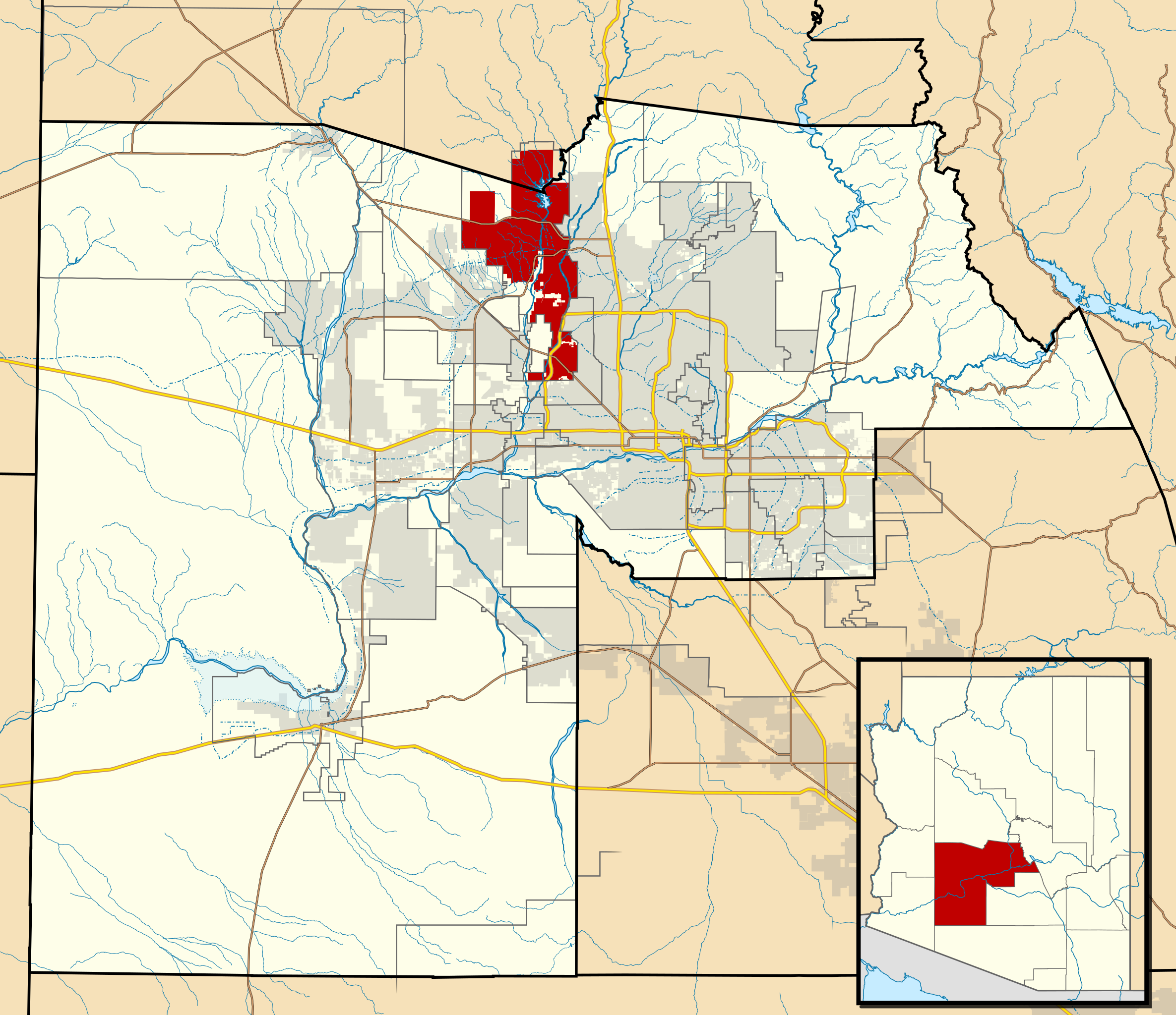
| വിവരണം | This map shows the incorporated areas and Indian reservation boundaries in Maricopa County, Arizona, along with water bodies and major highways and roads. Peoria is highlighted in red. Other incorporated cities are shown in gray, planning area borders for these cities and Indian reservation borders are shown as solid black lines. Changes from Previous Version: Updated the maps to include water bodies and to make "less boring" than the plain black/white/gray maps. Format was updated to match standards laid out by WikiProject Maps/Conventions. Map data is based on data from the following Webpage: Maricopa County Interactive GIS Map. I created this map in Inkscape. |
| തീയതി | |
| സ്രോതസ്സ് | My own work, based on government information |
| സ്രഷ്ടാവ് | Ixnayonthetimmay |
| അനുമതി (ഈ പ്രമാണത്തിന്റെ പുനരുപയോഗം) |
Public Domain |
| മറ്റു പതിപ്പുകൾ | See Category:Maps of Maricopa County for other versions of this image. |
അനുമതി
| ഈ സൃഷ്ടിയുടെ പകർപ്പവകാശ ഉടമയായ ഞാൻ, ഈ സൃഷ്ടി പൊതുസഞ്ചയത്തിൽ പ്രസിദ്ധീകരിച്ചിരിക്കുന്നു. ഇത് ആഗോള തലത്തിൽ ബാധകമാണ്. ചില രാജ്യങ്ങളിൽ ഇത് നിയമപ്രകാരം സാദ്ധ്യമല്ലെന്ന് വന്നേക്കാം; അങ്ങനെയെങ്കിൽ: ഈ സൃഷ്ടി, നിയമപ്രകാരം നിബന്ധനകൾ ഉണ്ടെങ്കിൽ അവയൊഴിച്ച്, യാതൊരു നിബന്ധനകളും ഇല്ലാതെ ഏതൊരാൾക്കും ഏതൊരു ഉപയോഗത്തിനും, ഉപയോഗപ്പെടുത്തുവാൻ ഞാൻ അനുവദിച്ചിരിക്കുന്നു. |
പ്രമാണ നാൾവഴി
ഏതെങ്കിലും തീയതി/സമയ കണ്ണിയിൽ ഞെക്കിയാൽ പ്രസ്തുതസമയത്ത് ഈ പ്രമാണം എങ്ങനെയായിരുന്നു എന്നു കാണാം.
| തീയതി/സമയം | ലഘുചിത്രം | അളവുകൾ | ഉപയോക്താവ് | അഭിപ്രായം | |
|---|---|---|---|---|---|
| നിലവിലുള്ളത് | 06:39, 20 മേയ് 2011 | | 940 × 812 (1.05 എം.ബി.) | Ixnayonthetimmay | Uploading new version |
| 04:33, 30 ഓഗസ്റ്റ് 2008 |  | 900 × 800 (413 കെ.ബി.) | Ixnayonthetimmay | == Summary == {{Information |Description=This map shows the incorporated areas and unincorporated areas in Maricopa County, Arizona. [[:en:Paloma, Arizona|Pa | |
| 00:17, 16 സെപ്റ്റംബർ 2007 |  | 900 × 800 (384 കെ.ബി.) | Ixnayonthetimmay | {{Information |Description= |Source= |Date= |Author= |Permission= |other_versions= }} | |
| 10:10, 28 മേയ് 2007 |  | 900 × 780 (329 കെ.ബി.) | Ixnayonthetimmay | ||
| 00:54, 22 മേയ് 2007 |  | 900 × 780 (318 കെ.ബി.) | Ixnayonthetimmay | ||
| 05:21, 30 ജനുവരി 2007 |  | 904 × 758 (189 കെ.ബി.) | Ixnayonthetimmay | {{Information |Description=This map shows the incorporated areas in Maricopa County, Arizona, highlighting Peoria in red. It also shows the boundaries for the mun |
പ്രമാണത്തിന്റെ ഉപയോഗം
താഴെ കാണുന്ന താളിൽ ഈ ചിത്രം ഉപയോഗിക്കുന്നു:
പ്രമാണത്തിന്റെ ആഗോള ഉപയോഗം
താഴെ കൊടുത്തിരിക്കുന്ന മറ്റ് വിക്കികൾ ഈ പ്രമാണം ഉപയോഗിക്കുന്നു:
- azb.wikipedia.org സംരംഭത്തിലെ ഉപയോഗം
- ceb.wikipedia.org സംരംഭത്തിലെ ഉപയോഗം
- de.wikipedia.org സംരംഭത്തിലെ ഉപയോഗം
- en.wikipedia.org സംരംഭത്തിലെ ഉപയോഗം
- eo.wikipedia.org സംരംഭത്തിലെ ഉപയോഗം
- fa.wikipedia.org സംരംഭത്തിലെ ഉപയോഗം
- fi.wikipedia.org സംരംഭത്തിലെ ഉപയോഗം
- ja.wikipedia.org സംരംഭത്തിലെ ഉപയോഗം
- nl.wikipedia.org സംരംഭത്തിലെ ഉപയോഗം
- pl.wikipedia.org സംരംഭത്തിലെ ഉപയോഗം
- pt.wikipedia.org സംരംഭത്തിലെ ഉപയോഗം
- sco.wikipedia.org സംരംഭത്തിലെ ഉപയോഗം
- sr.wikipedia.org സംരംഭത്തിലെ ഉപയോഗം
- sv.wikipedia.org സംരംഭത്തിലെ ഉപയോഗം
- sw.wikipedia.org സംരംഭത്തിലെ ഉപയോഗം
- ur.wikipedia.org സംരംഭത്തിലെ ഉപയോഗം
- vi.wikipedia.org സംരംഭത്തിലെ ഉപയോഗം
- zh.wikipedia.org സംരംഭത്തിലെ ഉപയോഗം