
പ്രമാണം:Kashmir Region (2020 skirmish locations).jpg
ഈ പ്രിവ്യൂവിന്റെ വലിപ്പം: 604 × 599 പിക്സലുകൾ. മറ്റ് റെസലൂഷനുകൾ: 242 × 240 പിക്സലുകൾ | 484 × 480 പിക്സലുകൾ | 774 × 768 പിക്സലുകൾ | 1,033 × 1,024 പിക്സലുകൾ | 1,579 × 1,566 പിക്സലുകൾ.
പൂർണ്ണ വലിപ്പം (1,579 × 1,566 പിക്സൽ, പ്രമാണത്തിന്റെ വലിപ്പം: 1.27 എം.ബി., മൈം തരം: image/jpeg)
| ഈ പ്രമാണം വിക്കിമീഡിയ കോമൺസിൽ നിന്നുള്ളതാണ്. പ്രമാണത്തെക്കുറിച്ചുള്ള വിവരണം താഴെ കൊടുത്തിരിക്കുന്നു.
|
.jpg?uselang=ml)
ചുരുക്കം
| വിവരണം |
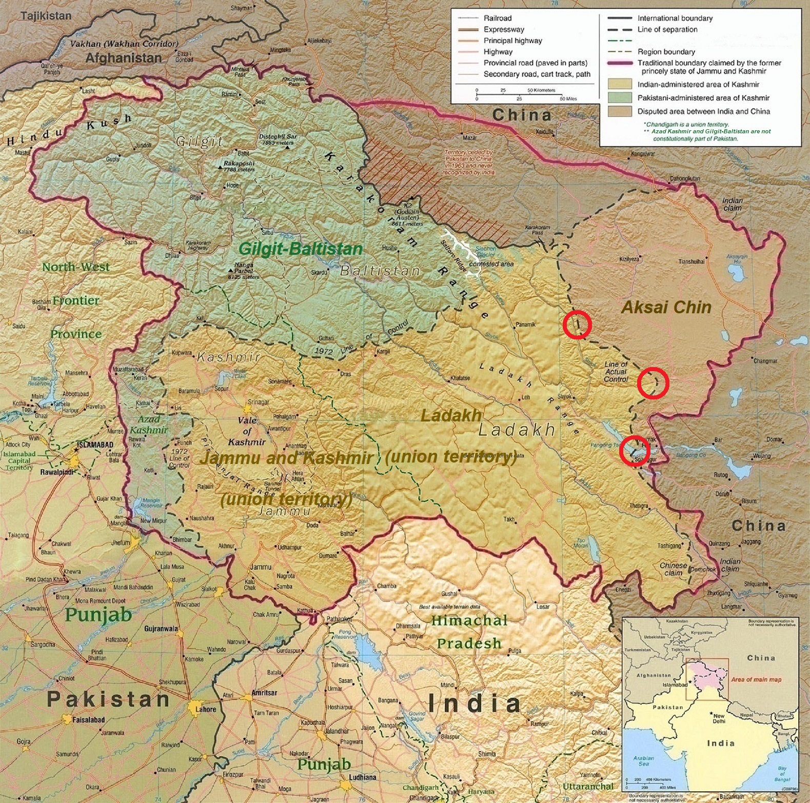
English: A map of the disputed Kashmir region created by the United States CIA in 2004 and hosted by the University of Texas at Austin Perry-Castañeda Library Map Collection; altered to show new jurisdictions by Fowler&fowler in November 2019; altered by to show 2020 skirmish locations by MarkH21 in June 2020. The red circles mark the rough locations of the conflicts at the the Galwan Valley (top), Hot Springs, Chang Chenmo Valley checkpoint (middle), and Pangong Tso (near the bottom). |
| തീയതി | |
| സ്രോതസ്സ് | Map of Kashmir region created by the US Central Intelligence Agency, 2004 |
| സ്രഷ്ടാവ് | United States Central Intelligence Agency |
| മറ്റു പതിപ്പുകൾ |
  |
അനുമതി
ഈ സൃഷ്ടി അമേരിക്കൻ ഐക്യനാടുകളിൽ പൊതുസഞ്ചയത്തിൽ ഉള്ളതാണ്, യു.എസ്. കോഡിലെ തലക്കെട്ട് 17, ആദ്ധ്യായം 1, ഭാഗം 105 പ്രകാരം അമേരിക്കൻ ഐക്യനാടുകളിലെ ഫെഡറൽ ഭരണകൂടത്തിന്റെ സൃഷ്ടി ആയതാണ് കാരണം. പകർപ്പവകാശം കാണുക.
ശ്രദ്ധിക്കുക: ഫെഡറൽ ഭരണകൂടത്തിന്റെ സൃഷ്ടികൾക്കു മാത്രമേ ഇതു ബാധകമായിരിക്കുകയുള്ളൂ, അമേരിക്കയിലെ സംസ്ഥാനങ്ങൾ, ടെറിട്ടറി, കോമൺവെൽത്ത്, കൗണ്ടി, മുനിസിപ്പാലിറ്റി, തുടങ്ങിയ ഉപവിഭജനങ്ങളുടെ സൃഷ്ടികൾക്ക് ഇത് ബാധകമായിരിക്കില്ല. അമേരിക്കൻ ഐക്യനാടുകളിലെ തപാൽ സേവനത്തിനായി 1978-നു ശേഷം പുറത്തിറക്കിയ തപാൽ സ്റ്റാമ്പ് രൂപകല്പനകൾക്കും ഈ ഫലകം ബാധകമാക്കരുത്. (206.02(b) കോംപെൻഡിയം II: പകർപ്പവകാശ മര്യാദകൾ കാണുക). അമേരിക്കൻ ഐക്യനാടുകളിലെ ചില നാണയങ്ങൾക്കും ഇതു ബാധകമല്ല, അമേരിക്കൻ ഐക്യനാടുകളിലെ കമ്മട്ടം, ഉപയോഗനിബന്ധനകൾ. കാണുക
|
 | |
| ഈ പ്രമാണം, പകർപ്പവകാശ നിയമത്തിന്റെ അറിയപ്പെടുന്ന എല്ലാ പരിമിതപ്പെടുത്തലുകളിൽ നിന്നും, ബന്ധപ്പെട്ടതും സമീപസ്ഥവുമായ എല്ലാ അവകാശങ്ങളുമടക്കം, സ്വതന്ത്രമാണെന്ന് കണ്ടെത്തിയിരിക്കുന്നു. | ||
| Annotations | This image is annotated: View the annotations at Commons |
.jpg)
പ്രമാണ നാൾവഴി
ഏതെങ്കിലും തീയതി/സമയ കണ്ണിയിൽ ഞെക്കിയാൽ പ്രസ്തുതസമയത്ത് ഈ പ്രമാണം എങ്ങനെയായിരുന്നു എന്നു കാണാം.
| തീയതി/സമയം | ലഘുചിത്രം | അളവുകൾ | ഉപയോക്താവ് | അഭിപ്രായം | |
|---|---|---|---|---|---|
| നിലവിലുള്ളത് | 18:45, 24 ജൂൺ 2020 | | 1,579 × 1,566 (1.27 എം.ബി.) | MarkH21 | Removed the Daulat Beg Oldi circle as not being an actual location of conflict; added the Hot Springs, Chang Chenmo Valley circle as an actual location of conflict. |
| 02:01, 24 ജൂൺ 2020 |  | 1,579 × 1,566 (1.27 എം.ബി.) | MarkH21 | Uploaded a work by United States Central Intelligence Agency, MarkH21 from [https://legacy.lib.utexas.edu/maps/middle_east_and_asia/kashmir_region_2004.jpg Map of Kashmir region] created by the US Central Intelligence Agency, 2004; altered by MarkH21 with UploadWizard |
പ്രമാണത്തിന്റെ ഉപയോഗം
താഴെ കാണുന്ന താളിൽ ഈ ചിത്രം ഉപയോഗിക്കുന്നു:
പ്രമാണത്തിന്റെ ആഗോള ഉപയോഗം
താഴെ കൊടുത്തിരിക്കുന്ന മറ്റ് വിക്കികൾ ഈ പ്രമാണം ഉപയോഗിക്കുന്നു:
- af.wikipedia.org സംരംഭത്തിലെ ഉപയോഗം
- ca.wikipedia.org സംരംഭത്തിലെ ഉപയോഗം
- en.wikipedia.org സംരംഭത്തിലെ ഉപയോഗം
- es.wikipedia.org സംരംഭത്തിലെ ഉപയോഗം
- fa.wikipedia.org സംരംഭത്തിലെ ഉപയോഗം
- fr.wikipedia.org സംരംഭത്തിലെ ഉപയോഗം
- he.wikipedia.org സംരംഭത്തിലെ ഉപയോഗം
- ja.wikipedia.org സംരംഭത്തിലെ ഉപയോഗം
- ka.wikipedia.org സംരംഭത്തിലെ ഉപയോഗം
- ne.wikipedia.org സംരംഭത്തിലെ ഉപയോഗം
- pnb.wikipedia.org സംരംഭത്തിലെ ഉപയോഗം
- pt.wikipedia.org സംരംഭത്തിലെ ഉപയോഗം
- ru.wikipedia.org സംരംഭത്തിലെ ഉപയോഗം
- simple.wikipedia.org സംരംഭത്തിലെ ഉപയോഗം
- so.wikipedia.org സംരംഭത്തിലെ ഉപയോഗം
- ta.wikipedia.org സംരംഭത്തിലെ ഉപയോഗം
- te.wikipedia.org സംരംഭത്തിലെ ഉപയോഗം
- th.wikipedia.org സംരംഭത്തിലെ ഉപയോഗം
- tr.wikipedia.org സംരംഭത്തിലെ ഉപയോഗം
- uk.wikipedia.org സംരംഭത്തിലെ ഉപയോഗം
- ur.wikipedia.org സംരംഭത്തിലെ ഉപയോഗം
- vi.wikipedia.org സംരംഭത്തിലെ ഉപയോഗം
- www.wikidata.org സംരംഭത്തിലെ ഉപയോഗം
- zh.wikipedia.org സംരംഭത്തിലെ ഉപയോഗം
.jpg)