
പ്രമാണം:A Long Barrow - geograph.org.uk - 21533.jpg
കൂടുതൽ വ്യക്തതയുള്ള ചിത്രം ലഭ്യമല്ല.
A_Long_Barrow_-_geograph.org.uk_-_21533.jpg (640 × 480 പിക്സൽ, പ്രമാണത്തിന്റെ വലിപ്പം: 95 കെ.ബി., മൈം തരം: image/jpeg)
| ഈ പ്രമാണം വിക്കിമീഡിയ കോമൺസിൽ നിന്നുള്ളതാണ്. പ്രമാണത്തെക്കുറിച്ചുള്ള വിവരണം താഴെ കൊടുത്തിരിക്കുന്നു.
|
ചുരുക്കം
| വിവരണം |
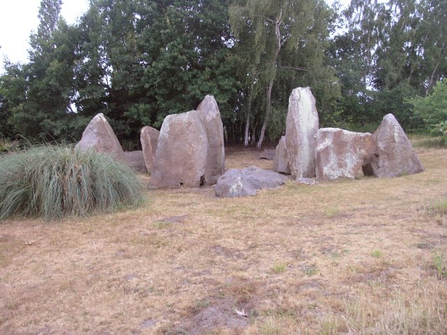
English: A Long Barrow. This has got to be the most impressive garden feature I've seen. In the grounds of a private residence, this is the best preserved long barrow in this area of Kent. What remains is the stone structure, which originally would have been covered by earth. 1,500 years older than Stonehenge, this is an ancient burial chamber built using local stones and originally covered by earth, with the chamber itself being between the two middle stones and the other stones supporting the earth structure. The central stones are about 3m tall and would have originally been topped by a capping stone (now just visible in the picture on the ground behind the stones). There are many other barrows in this area of Kent, but this has been re-built in the 1950s when the barrow was archaeologically investigated. |
| തീയതി | |
| സ്രോതസ്സ് | From geograph.org.uk |
| സ്രഷ്ടാവ് | Hywel Williams |
| കടപ്പാട് (അനുമതി പ്രകാരം ആവശ്യമാണ്) | Hywel Williams / A Long Barrow / |
| ഛായാഗ്രാഹിയുടെ സ്ഥാനം | | സ്ഥാനമനുസരിച്ച് ഇതും മറ്റു ചിത്രങ്ങളും: ഓപ്പൺസ്ട്രീറ്റ്മാപ്പ് |
|---|
_heading:270.00&language=ml)
| വസ്തുവിന്റെ സ്ഥാനം | | സ്ഥാനമനുസരിച്ച് ഇതും മറ്റു ചിത്രങ്ങളും: ഓപ്പൺസ്ട്രീറ്റ്മാപ്പ് |
|---|
_heading:270.00&language=ml)
അനുമതി

|
ഈ ചിത്രം ജിയോഗ്രാഫ് പദ്ധതി ശേഖരത്തിൽ നിന്നും എടുത്തതാണ്. ജിയോഗ്രാഫ് വെബ്സൈറ്റിൽ, ഛായാഗ്രാഹകന്റെ വിവരങ്ങൾക്കായി ഈ ചിത്രത്തിന്റെ താൾ കാണുക. ഈ ചിത്രത്തിന്റെ പകർപ്പവകാശ ഉടമ Hywel Williams ആണ്, ചിത്രം ക്രിയേറ്റീവ് കോമൺസ് ആട്രിബ്യൂഷൻ-ഷെയർഎലൈക് 2.0 അനുമതി പ്രകാരം പ്രസിദ്ധീകരിച്ചിരിക്കുന്നു.
|
ഈ പ്രമാണത്തിന് അനുമതി നൽകപ്പെട്ടിരിക്കുന്നത് ക്രിയേറ്റീവ് കോമൺസ് ആട്രിബ്യൂഷൻ 2.0 ആട്രിബ്യൂഷൻ-ഷെയർ എലൈക് സാമാന്യ അനുവാദപത്ര പ്രകാരമാണ്.
കടപ്പാട്: Hywel Williams
- താങ്കൾക്കുള്ള സ്വാതന്ത്ര്യങ്ങൾ:
- പങ്ക് വെയ്ക്കൽ – കൃതി പകർത്താനും, വിതരണം ചെയ്യാനും, പ്രസരിപ്പിക്കാനും
- പുനഃമിശ്രണം ചെയ്യൽ – കൃതി അനുയുക്തമാക്കാൻ
- താഴെ പറയുന്ന ഉപാധികൾ പാലിക്കുക:
- കടപ്പാട് – രചയിതാവോ അനുമതിയുള്ളയാളോ വ്യക്തമാക്കിയിട്ടുള്ള വിധത്തിൽ കൃതിയ്ക്കുള്ള കടപ്പാട് താങ്കൾ നൽകിയിരിക്കണം. താങ്കൾക്കിത് ഏത് വിധത്തിൽ വേണമെങ്കിലും ചെയ്യാവുന്നതാണ്, പക്ഷേ അത് അവർ താങ്കളേയോ താങ്കളുടെ ഉപയോഗത്തേയോ അടിച്ചേൽപ്പിച്ചതു പോലെയാവരുത്.
- ഇതു പോലെ പങ്ക് വെയ്ക്കുക – ഈ സൃഷ്ടിയെ പുനഃമിശ്രണം ചെയ്തോ രൂപാന്തരപ്പെടുത്തിയോ അടിസ്ഥാനപ്പെടുത്തിയോ ഉണ്ടാക്കുന്നവ; താങ്കളുടെ സംഭാവനയടക്കമുള്ള സൃഷ്ടി യഥാർത്ഥ സൃഷ്ടിയുടെ അതേ അല്ലെങ്കിൽ അനുരൂപമായ ഉപയോഗാനുമതിയിൽ മാത്രമേ താങ്കൾ വിതരണം ചെയ്യാവൂ.
പ്രമാണ നാൾവഴി
ഏതെങ്കിലും തീയതി/സമയ കണ്ണിയിൽ ഞെക്കിയാൽ പ്രസ്തുതസമയത്ത് ഈ പ്രമാണം എങ്ങനെയായിരുന്നു എന്നു കാണാം.
| തീയതി/സമയം | ലഘുചിത്രം | അളവുകൾ | ഉപയോക്താവ് | അഭിപ്രായം | |
|---|---|---|---|---|---|
| നിലവിലുള്ളത് | 01:21, 30 ജനുവരി 2010 | | 640 × 480 (95 കെ.ബി.) | GeographBot | == {{int:filedesc}} == {{Information |description={{en|1=A Long Barrow. This has got to be the most impressive garden feature I've seen. In the grounds of a private residence, this is the best preserved long barrow in this area of Kent. What remains is |
പ്രമാണത്തിന്റെ ഉപയോഗം
താഴെ കാണുന്ന താളിൽ ഈ ചിത്രം ഉപയോഗിക്കുന്നു:
പ്രമാണത്തിന്റെ ആഗോള ഉപയോഗം
താഴെ കൊടുത്തിരിക്കുന്ന മറ്റ് വിക്കികൾ ഈ പ്രമാണം ഉപയോഗിക്കുന്നു:
- ar.wikipedia.org സംരംഭത്തിലെ ഉപയോഗം
- de.wikipedia.org സംരംഭത്തിലെ ഉപയോഗം
- en.wikipedia.org സംരംഭത്തിലെ ഉപയോഗം
- fa.wikipedia.org സംരംഭത്തിലെ ഉപയോഗം
- id.wikipedia.org സംരംഭത്തിലെ ഉപയോഗം