
പ്രമാണം:1945-05-01GerWW2BattlefrontAtlas.jpg
ഈ പ്രിവ്യൂവിന്റെ വലിപ്പം: 614 × 600 പിക്സലുകൾ. മറ്റ് റെസലൂഷനുകൾ: 246 × 240 പിക്സലുകൾ | 491 × 480 പിക്സലുകൾ | 786 × 768 പിക്സലുകൾ | 1,244 × 1,215 പിക്സലുകൾ.
പൂർണ്ണ വലിപ്പം (1,244 × 1,215 പിക്സൽ, പ്രമാണത്തിന്റെ വലിപ്പം: 1.87 എം.ബി., മൈം തരം: image/jpeg)
| ഈ പ്രമാണം വിക്കിമീഡിയ കോമൺസിൽ നിന്നുള്ളതാണ്. പ്രമാണത്തെക്കുറിച്ചുള്ള വിവരണം താഴെ കൊടുത്തിരിക്കുന്നു.
|
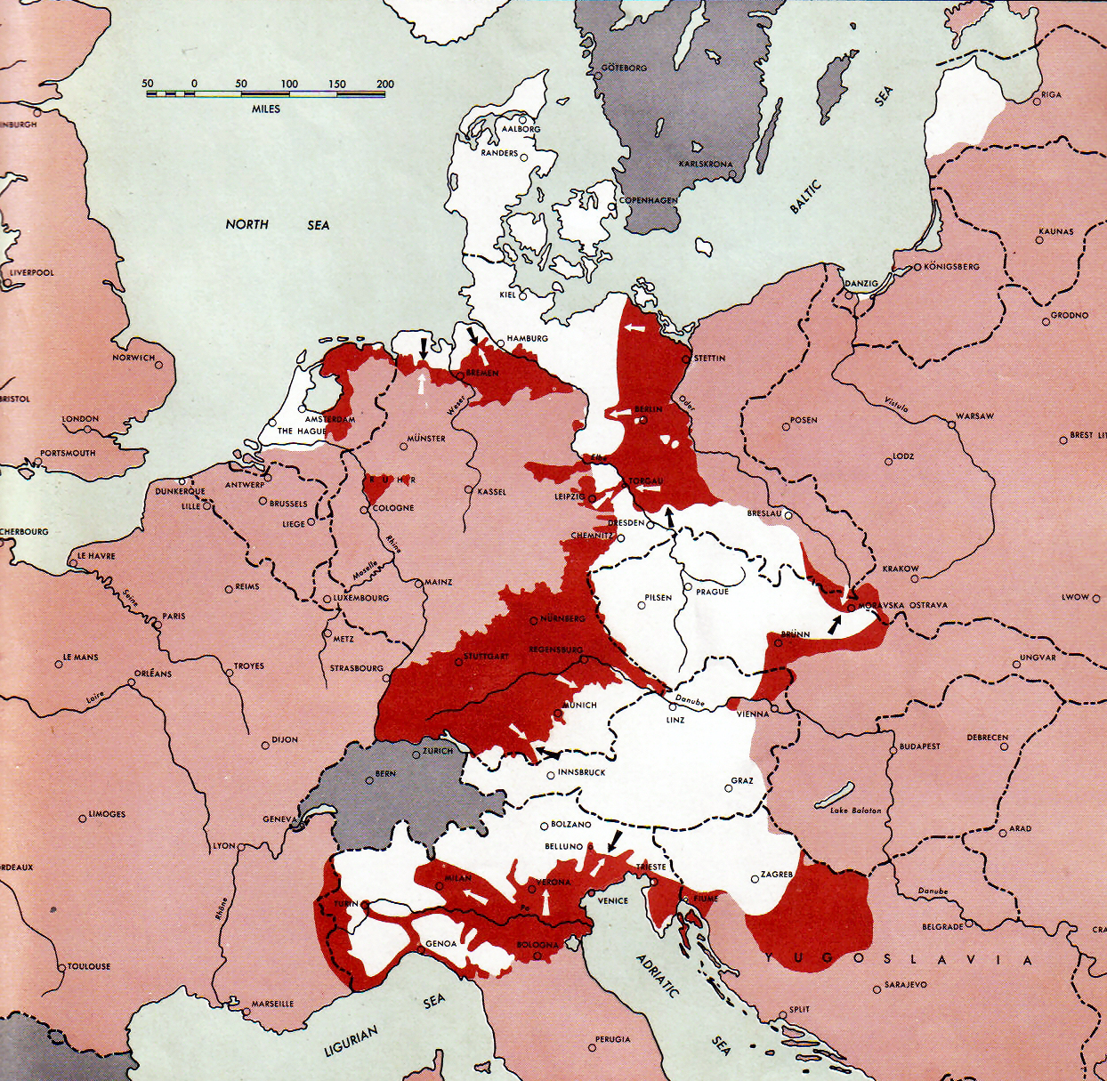
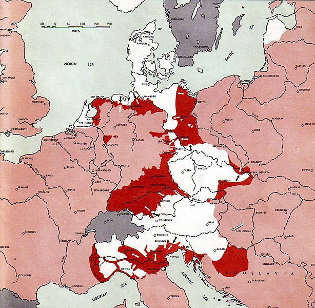
Atlas of the World Battle Fronts - War against Germany: 1945-05-01
← Previous map: 1945-04-15
→ Next map: 1945-05-15
ചുരുക്കം
| വിവരണം |
Neutral nations (Sweden, Switzerland, Spain, etc.)
Under Allied control
Allied forces
Axis forces
  July 1, 1943 to June 30 1945 To the Secretary of War". (See Cover, Forward and Map details)  |
| തീയതി | |
| സ്രോതസ്സ് | Document "Atlas of the World Battle Fronts in Semimonthly Phases to August 15th 1945: Supplement to The Biennial report of the Chief of Staff of the United States Army July 1, 1943 to June 30 1945 To the Secretary of War" |
| സ്രഷ്ടാവ് | Army Map Service |
| അനുമതി (ഈ പ്രമാണത്തിന്റെ പുനരുപയോഗം) |
Public Domain: Work of US army |
അനുമതി
ഈ ചിത്രം അല്ലെങ്കിൽ പ്രമാണം, അമേരിക്കൻ ഐക്യനാടുകളുടെ കരസേനയിലെ ജവാൻ അഥവാ ഉദ്യോഗസ്ഥൻ, തന്റെ ഔദ്യോഗിക കർത്തവ്യ നിർവ്വഹണത്തിന്റെ ഭാഗമായി സൃഷ്ടിച്ചതാണ്. അതുകൊണ്ട് അമേരിക്കൻ ഐക്യനാടുകളുടെ ഫെഡറൽ ഭരണകൂടത്തിന്റെ കൃതി ആയതിനാൽ, ചിത്രം അല്ലെങ്കിൽ പ്രമാണം പൊതുസഞ്ചയത്തിൽ പെടുന്നു.
|
 |
പ്രമാണ നാൾവഴി
ഏതെങ്കിലും തീയതി/സമയ കണ്ണിയിൽ ഞെക്കിയാൽ പ്രസ്തുതസമയത്ത് ഈ പ്രമാണം എങ്ങനെയായിരുന്നു എന്നു കാണാം.
| തീയതി/സമയം | ലഘുചിത്രം | അളവുകൾ | ഉപയോക്താവ് | അഭിപ്രായം | |
|---|---|---|---|---|---|
| നിലവിലുള്ളത് | 13:53, 10 സെപ്റ്റംബർ 2011 | | 1,244 × 1,215 (1.87 എം.ബി.) | Finavon | Reverted to version as of 15:34, 6 November 2010 COM:USOP and en:MOS:IMAGES |
| 03:15, 10 സെപ്റ്റംബർ 2011 |  | 1,274 × 1,715 (1.82 എം.ബി.) | Whoop whoop pull up | Reverted to version as of 23:50, 2 April 2011: Rv unexplained and unneeded crop. | |
| 11:30, 2 ജൂൺ 2011 |  | 1,244 × 1,215 (1.87 എം.ബി.) | DIREKTOR | ||
| 23:50, 2 ഏപ്രിൽ 2011 |  | 1,274 × 1,715 (1.82 എം.ബി.) | Whoop whoop pull up | Reverted to version as of 20:15, 24 December 2007 The caption is very useful and practically all the other pictures in this series have retained them. | |
| 15:34, 6 നവംബർ 2010 |  | 1,244 × 1,215 (1.87 എം.ബി.) | DIREKTOR | Crop | |
| 20:15, 24 ഡിസംബർ 2007 |  | 1,274 × 1,715 (1.82 എം.ബി.) | Mike Young | {{Information |Description= thumb|left|75pxthumb|right|75pxMap of the front against Germany: This map is taken from the source "Atlas of the World Battle Fronts in Semimonthly |
പ്രമാണത്തിന്റെ ഉപയോഗം
താഴെ കാണുന്ന താളിൽ ഈ ചിത്രം ഉപയോഗിക്കുന്നു:
പ്രമാണത്തിന്റെ ആഗോള ഉപയോഗം
താഴെ കൊടുത്തിരിക്കുന്ന മറ്റ് വിക്കികൾ ഈ പ്രമാണം ഉപയോഗിക്കുന്നു:
- ar.wikipedia.org സംരംഭത്തിലെ ഉപയോഗം
- az.wikipedia.org സംരംഭത്തിലെ ഉപയോഗം
- be.wikipedia.org സംരംഭത്തിലെ ഉപയോഗം
- bg.wikipedia.org സംരംഭത്തിലെ ഉപയോഗം
- bs.wikipedia.org സംരംഭത്തിലെ ഉപയോഗം
- ca.wikipedia.org സംരംഭത്തിലെ ഉപയോഗം
- cs.wikipedia.org സംരംഭത്തിലെ ഉപയോഗം
- da.wikipedia.org സംരംഭത്തിലെ ഉപയോഗം
- de.wikipedia.org സംരംഭത്തിലെ ഉപയോഗം
- el.wikipedia.org സംരംഭത്തിലെ ഉപയോഗം
- en.wikipedia.org സംരംഭത്തിലെ ഉപയോഗം
- Battle of Berlin
- Italian campaign (World War II)
- Bleiburg repatriations
- Death of Adolf Hitler
- Flensburg Government
- Courland Pocket
- World War II in Yugoslavia
- Timeline of World War II (1945–1991)
- User:Eurocopter/Sandbox/Archive 1
- Wikipedia talk:Requests for mediation/Draza Mihailovic/Archive20
- Wikipedia:Reference desk/Archives/Humanities/2012 November 10
- User:Chickstarr404/Gather lists/12545 – "Exorcising Hitler"
- en.wikisource.org സംരംഭത്തിലെ ഉപയോഗം
- eo.wikipedia.org സംരംഭത്തിലെ ഉപയോഗം
- es.wikipedia.org സംരംഭത്തിലെ ഉപയോഗം
- et.wikipedia.org സംരംഭത്തിലെ ഉപയോഗം
- fa.wikipedia.org സംരംഭത്തിലെ ഉപയോഗം
- fi.wikipedia.org സംരംഭത്തിലെ ഉപയോഗം
- fr.wikipedia.org സംരംഭത്തിലെ ഉപയോഗം
- he.wikipedia.org സംരംഭത്തിലെ ഉപയോഗം
- hr.wikipedia.org സംരംഭത്തിലെ ഉപയോഗം
- hy.wikipedia.org സംരംഭത്തിലെ ഉപയോഗം
ഈ പ്രമാണത്തിന്റെ കൂടുതൽ ആഗോള ഉപയോഗം കാണുക.