സാൻ ജൊവാക്വിൻ താഴ്വര
| സാൻ ജൊവാക്വിൻ താഴ്വര | |
|---|---|
 San Joaquin Valley | |
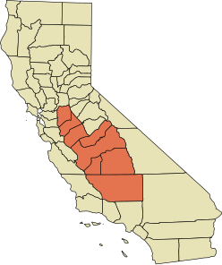
 A map of the counties encompassing the San Joaquin Valley ecoregion | |
| Geography | |
| Location | California, United States |
| Population centers | Stockton, Porterville, Modesto, Turlock, Merced, Fresno, Visalia, Bakersfield, Clovis |
| Borders on | Sierra Nevada (east), Sacramento–San Joaquin River Delta (north), Coast Range, San Francisco Bay (west), Tehachapi Mountains (south) |
| Coordinates | 36°37′44″N 120°11′06″W / 36.62889°N 120.18500°W |
| Traversed by | Interstate 5, State Route 99 |
| Rivers | San Joaquin River |
സാൻ ജൊവാക്വിൻ താഴ്വര അമേരിക്കൻ ഐക്യനാടുകളിലെ സംസ്ഥാനമായ കാലിഫോർണിയയിലെ മദ്ധ്യ താഴ്വരാ പ്രദേശമാണ്. ഇത് സക്രാമെന്റോ-സാൻ ജൊവാക്വിൻ നദികളുടെ അഴിമുഖത്തിനു തെക്ക് വശത്താതായാണ് സ്ഥിതിചെയ്യുന്നത്. സാൻ ജൊവാക്വിൻ നദി ഈ താഴ്വരയിലൂടെ ഒഴുകുന്നു. ഈ താഴ്വരയിൽ വടക്കുള്ള ഏഴു കൗണ്ടികളും തെക്കൻ കാലിഫോർണിയയിലെ ഒന്നും ഉൾപ്പെടെയുള്ള പ്രദേശങ്ങളാണുള്ളത്. വടക്കൻ മേഖലയിലെ സാൻ ജൊവാക്വിൻ, കിംഗ്സ് കൗണ്ടികൾ മുഴുവനായും സ്റ്റാനിസ്ലൌസ്, മെർസ്ഡ്, ഫ്രെസ്നോ കൗണ്ടികളുടെ ഭൂരിപക്ഷവും മഡേറ, ടുലെയർ കൗണ്ടികളുടെ ഭാഗങ്ങളും അതോടൊപ്പം തെക്കൻ കാലിഫോർണിയയിലെ കേൺ കൗണ്ടിയുടെ ഏറിയകൂറും ഉൾക്കൊണ്ടിരിക്കുന്നു.[1] താഴ്വരയുടെ ഭൂരിഭാഗം പ്രദേശങ്ങളും ഗ്രാമീണമേഖലയാണെങ്കിലും അതിൽ ഫ്രെസ്നോ, ബേക്കർസ്ഫീൽഡ്, സ്റ്റോക്ക്ടൺ, മോഡേസ്റ്റോ, ടർലോക്ക്, പോർട്ടർവില്ലെ, വിസാലിയ, മെർസ്ഡ്, ഹാൻഫോർഡ് തുടങ്ങിയ നഗരങ്ങൾ നിലനിൽക്കുന്നുണ്ട്.
സാൻ ജോവാക്വിൻ താഴ്വരയിലെ ആദ്യ അധിവാസികൾ യോക്കുട്സ്, മിവോക്ക് ജനങ്ങളായിരുന്നു. 1772 ൽ ഇവിടെയെത്തിയ പെഡ്രോ ഫാഗെസ് ആണ് ഈ പ്രദേശത്തേക്ക് എത്തിയ ആദ്യ യൂറോപ്യൻ വംശജൻ.[2]
ഭൂമിശാസ്ത്രം[തിരുത്തുക]
സാൻ ജോക്വിൻ താഴ്വര വടക്ക് സാക്രമെന്റോ-സാൻ ജോക്വിൻ നദി ഡെൽറ്റ മുതൽ തെക്ക് തെഹാചാപ്പി പർവതനിരകൾ വരെയും പടിഞ്ഞാറ് വിവിധ കാലിഫോർണിയ തീരപ്രദേശങ്ങൾ (വടക്ക് ഡയാബ്ലോ റേഞ്ച് മുതൽ തെക്ക് ടെംബ്ലർ റേഞ്ച് വരെ) മുതൽ കിഴക്ക് സിയറ നെവാഡയിലേക്കുവരെ വ്യാപിച്ചുകിടക്കുന്നു.
അവലംബം[തിരുത്തുക]
- ↑ "San Joaquin Valley Fact Sheet". Valley Clean Air Now. Archived from the original on October 22, 2014. Retrieved October 18, 2014.
Seven counties comprise the San Joaquin Valley, including all of Kings County, most of Fresno, Kern, Merced, and Stanislaus counties, and portions of Madera, San Luis Obispo, Tulare counties
- ↑ Capace, Nancy (1999). Encyclopedia of California. North American Book Dist LLC. Page 410. ISBN 9780403093182.
