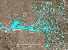
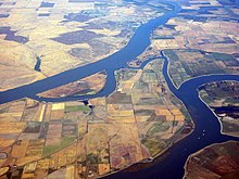
സാക്രമെൻറോ-സാൻ ജോയക്വിൻ നദി ഡെൽറ്റ


അമേരിക്കൻ ഐക്യനാടുകളിലെ ഒരു സംസ്ഥാനമായ വടക്കൻ കാലിഫോർണിയയിലെ നദീമുഖ ഡെൽറ്റ പ്രദേശമാണ് സാക്രമെൻറോ-സാൻ ജോയക്വിൻ നദി ഡെൽറ്റ. സൂയിസൺ ഉൾക്കടലിൽ പതിക്കുന്ന സാക്രമെൻറൊ നദിയുടെയയും സാൻ ജോയക്വിൻ നദിയുടെയും പടിഞ്ഞാറെ അരികിലുള്ള മധ്യതാഴ്വരയിൽ കാണപ്പെടുന്ന ഡെൽറ്റയാണിത്. കാലിഫോർണിയ സംസ്ഥാനത്തെ ജലസ്രോതസ്സ് നിയന്ത്രണ സമിതി പ്രസിദ്ധീകരിക്കുന്ന കാലിഫോർണിയ ബേയ്സ് ആൻഡ് ഇസ്റ്റ്യൂറിയസ് [1]പോളിസിയിൽ ഡെൽറ്റയുടെ സംരക്ഷണത്തെക്കുറിച്ച് മനസ്സിലാക്കാൻ സാധിക്കുന്നു. 2,800ചതുരശ്രകിലോമീറ്റർ ഡെൽറ്റ പ്രദേശമാണിത്.


അവലംബം[തിരുത്തുക]
- ↑ State Water Resources Control Board (1974). Water Quality Control Policy for the Enclosed Bays and Estuaries of California. State of California.
പുറത്തേയ്ക്കുള്ള കണ്ണികൾ[തിരുത്തുക]
Sacramento–San Joaquin River Delta എന്ന വിഷയവുമായി ബന്ധപ്പെട്ട ചിത്രങ്ങൾ വിക്കിമീഡിയ കോമൺസിലുണ്ട്.
- California Delta Chambers and Visitors Bureau
- Sacramento-San Joaquin Delta Conservancy
- Delta Wetlands Project
- Sacramento-San Joaquin Delta Atlas Archived 2017-06-16 at the Wayback Machine. at California Department of Water Resources
- Bay-Delta: Levees, Climate Change, and Water Quality
- What is this place called the Delta? (slideshow) Archived 2012-12-11 at the Wayback Machine.
- Delta Waterways Archived 2011-07-08 at the Wayback Machine. at California Department of Water Resources
- SFGate: Deluge in the Delta (4 Jun 2004) Archived 2009-10-08 at the Wayback Machine.
- Cnet – Visiting SF Bay (and delta) in a warehouse. Article by Daniel Terdimen, photos by James Martin, Cnet News, Aug 27, 2007
- Cnet – Barge-scale cleanup in California waterways (photos), by James Martin, March 20, 2010[പ്രവർത്തിക്കാത്ത കണ്ണി]
- Cnet – Engineering a massive cleanup of toxic waterways (photos), by James Martin, March 20, 2010[പ്രവർത്തിക്കാത്ത കണ്ണി]
- San Joaquin Delta Land Reclamation Photographs, ca. 1904–1907, The Bancroft Library

