പ്രമാണം:Wpdms usgs photo sacramento delta 2.jpg

Page contents not supported in other languages.
വിക്കിപീഡിയ, ഒരു സ്വതന്ത്ര വിജ്ഞാനകോശം.

Wpdms_usgs_photo_sacramento_delta_2.jpg(700 × 520 പിക്സൽ, പ്രമാണത്തിന്റെ വലിപ്പം: 81 കെ.ബി., മൈം തരം: image/jpeg)

വിവരണം

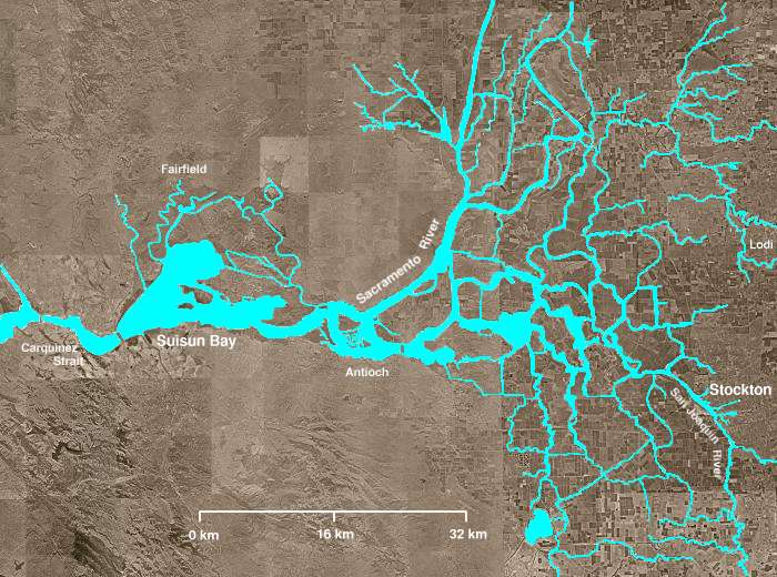
The Sacramento-San Joaquin River Delta of California - covering the right half of the map.

  • The Sacramento River flows into the delta from the north and the San Joaquin River from the south. The San Joaquin and Sacramento rivers meet just west of Antioch and their confluence continues westward into Suisun Bay and then the Carquinez Strait (both on left of map).
  • The Mokelumne River enters from the east, flows northwest from Lodi, picks up several tributaries including the Cosumnes River, then turns south, meandering among several delta sloughs and waterways, ultimately flowing into the San Joaquin River in the center of the delta, northeast of Antioch.
  • The "lake-like" body of water near the bottom of the image is Clifton Court Forebay, where pumps lift water to be sent southward in the California Water Project canal.
  • Several other open areas in the right half of the image are "islands," many of which have elevations well below sea level. Waterways (in blue) are clearly visible, as are fields and croplands (which appear as patchwork), and urban areas (especially Stockton).
തീയതി
സ്രോതസ്സ് http://en.wikipedia.org/wiki/Image:Wpdms_usgs_photo_sacramento_delta_2.jpg
സ്രഷ്ടാവ് Matthew Trump
അനുമതി
(ഈ പ്രമാണത്തിന്റെ പുനരുപയോഗം)
ഈ സൃഷ്ടിയുടെ പകർപ്പവകാശ ഉടമയായ ​English Wikipedia user Decumanus, താഴെ പറയുന്ന അനുമതിയിൽ ഈ സൃഷ്ടി ഇതിനാൽ പ്രസിദ്ധീകരിച്ചിരിക്കുന്നു:
GNU head സ്വതന്ത്ര സോഫ്റ്റ്‌‌വേർ സമിതി പ്രസിദ്ധീകരിച്ചിട്ടുള്ള ഗ്നു സ്വതന്ത്ര പ്രമാണ അനുവാദപത്രം പതിപ്പ് 1.2 അല്ലെങ്കിൽ പുതിയ പതിപ്പുകൾ പ്രകാരം; മാറ്റമില്ലാത്ത ഭാഗങ്ങളില്ലാതെ, മുൻചട്ടയിലെ എഴുത്തുകൾ ഇല്ലാതെ, പിൻചട്ടയിലെ എഴുത്തുകൾ ഇല്ലാതെ പകർത്താനും, വിതരണം ചെയ്യാനും ഒപ്പം/അല്ലെങ്കിൽ ഈ പ്രമാണത്തിൽ മാറ്റം വരുത്തുവാനും ഉള്ള അവകാശങ്ങൾ നൽകുന്നു. ഗ്നു സ്വതന്ത്ര പ്രമാണ അനുവാദപത്രം എന്ന തലക്കെട്ടിൽ അനുവാദപത്രത്തിന്റെ ഒരു പകർപ്പ് ഉൾപ്പെടുത്തിയിട്ടുണ്ട്.
w:ml:ക്രിയേറ്റീവ് കോമൺസ്
കടപ്പാട് ഇതു പോലെ പങ്ക് വെയ്ക്കുക
ഈ പ്രമാണത്തിന് അനുമതി നൽകപ്പെട്ടിരിക്കുന്നത് ക്രിയേറ്റീവ് കോമൺസ് ആട്രിബ്യൂഷൻ-ഷെയർ എലൈക് 3.0 അൺപോർട്ടഡ് അനുവാദപത്ര പ്രകാരമാണ്.
കടപ്പാട്: English Wikipedia user Decumanus
താങ്കൾക്കുള്ള സ്വാതന്ത്ര്യങ്ങൾ:
  • പങ്ക് വെയ്ക്കൽ – കൃതി പകർത്താനും, വിതരണം ചെയ്യാനും, പ്രസരിപ്പിക്കാനും
  • പുനഃമിശ്രണം ചെയ്യൽ – കൃതി അനുയുക്തമാക്കാൻ
താഴെ പറയുന്ന ഉപാധികൾ പാലിക്കുക:
  • കടപ്പാട് – രചയിതാവോ അനുമതിയുള്ളയാളോ വ്യക്തമാക്കിയിട്ടുള്ള വിധത്തിൽ കൃതിയ്ക്കുള്ള കടപ്പാട് താങ്കൾ നൽകിയിരിക്കണം. താങ്കൾക്കിത് ഏത് വിധത്തിൽ വേണമെങ്കിലും ചെയ്യാവുന്നതാണ്, പക്ഷേ അത് അവർ താങ്കളേയോ താങ്കളുടെ ഉപയോഗത്തേയോ അടിച്ചേൽപ്പിച്ചതു പോലെയാവരുത്.
  • ഇതു പോലെ പങ്ക് വെയ്ക്കുക – ഈ സൃഷ്ടിയെ പുനഃമിശ്രണം ചെയ്തോ രൂപാന്തരപ്പെടുത്തിയോ അടിസ്ഥാനപ്പെടുത്തിയോ ഉണ്ടാക്കുന്നവ; താങ്കളുടെ സംഭാവനയടക്കമുള്ള സൃഷ്ടി യഥാർത്ഥ സൃഷ്ടിയുടെ അതേ അല്ലെങ്കിൽ അനുരൂപമായ ഉപയോഗാനുമതിയിൽ മാത്രമേ താങ്കൾ വിതരണം ചെയ്യാവൂ.
ജി.എഫ്.ഡി.എൽ. അനുവാദപത്രത്തിന്റെ അനുമതി പുതുക്കലിന്റെ ഭാഗമായാണ് ഈ ടാഗ് ചേർക്കപ്പെട്ടിരിക്കുന്നത്.
മറ്റു പതിപ്പുകൾ ഈ പ്രമാണത്തിൽ നിന്നും സൃഷ്ടിച്ചവ:  California Grizzly Bear walking in the Delta Region.jpg

en:Sacramento-San Joaquin River Delta

തലവാചകങ്ങൾ

ഈ പ്രമാണം എന്തിനെ പ്രതിനിധീകരിക്കുന്നുവെന്ന ഒറ്റവരി വിശദീകരണം ചേർക്കുക
The Sacramento-San Joaquin River Delta of California

ഈ പ്രമാണത്തിൽ ചിത്രീകരിച്ചിരിക്കുന്ന ഇനങ്ങൾ

സൃഷ്ടിയിലുള്ളത്

പ്രമാണ നാൾവഴി

ഏതെങ്കിലും തീയതി/സമയ കണ്ണിയിൽ ഞെക്കിയാൽ പ്രസ്തുതസമയത്ത് ഈ പ്രമാണം എങ്ങനെയായിരുന്നു എന്നു കാണാം.

തീയതി/സമയംലഘുചിത്രംഅളവുകൾഉപയോക്താവ്അഭിപ്രായം
നിലവിലുള്ളത്03:21, 8 ഓഗസ്റ്റ് 200803:21, 8 ഓഗസ്റ്റ് 2008-ലെ പതിപ്പിന്റെ ലഘുചിത്രം700 × 520 (81 കെ.ബി.)Captndelta{{Information |Description=The Sacramento-San Joaquin River Delta covers the right half of this image. The Sacramento River flows into the delta from the north and the San Joaquin River from the south. The Mokelumne River

താഴെ കാണുന്ന താളിൽ ഈ ചിത്രം ഉപയോഗിക്കുന്നു:

പ്രമാണത്തിന്റെ ആഗോള ഉപയോഗം

താഴെ കൊടുത്തിരിക്കുന്ന മറ്റ് വിക്കികൾ ഈ പ്രമാണം ഉപയോഗിക്കുന്നു:

മെറ്റാഡാറ്റ

"https://ml.wikipedia.org/wiki/പ്രമാണം:Wpdms_usgs_photo_sacramento_delta_2.jpg" എന്ന താളിൽനിന്ന് ശേഖരിച്ചത്