
പ്രമാണം:Punjab 1903.gif
Punjab_1903.gif (640 × 480 പിക്സൽ, പ്രമാണത്തിന്റെ വലിപ്പം: 338 കെ.ബി., മൈം തരം: image/gif)
| ഈ പ്രമാണം വിക്കിമീഡിയ കോമൺസിൽ നിന്നുള്ളതാണ്. പ്രമാണത്തെക്കുറിച്ചുള്ള വിവരണം താഴെ കൊടുത്തിരിക്കുന്നു.
|
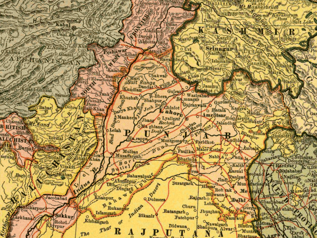
In this map, the British Raj Punjab province is colored pink, and the Indian princely states are colored yellow. As the map indicates, a number of princely states, mostly in the eastern Punjab, fell under the political authority of the British Governor of the Punjab. From map of India by Dodd, Mead and Company, 1903. Library of Congress Geography and Map Collection. Call Number G7650 1903 .D6 TIL
|
ഇത് സ്രഷ്ടാവിന്റെ ജീവിതകാലത്തിനു ശേഷം 70 അല്ലെങ്കിൽ അതിൽക്കുറവ് വർഷങ്ങൾ എന്നു പകർപ്പവകാശ കാലാവധി നിജപ്പെടുത്തിയിട്ടുള്ള രാജ്യങ്ങളിലും അഥവാ പ്രദേശങ്ങളിലും പൊതുസഞ്ചയത്തിൽ ഉൾപ്പെടുന്നു.
| |
| ഈ പ്രമാണം, പകർപ്പവകാശ നിയമത്തിന്റെ അറിയപ്പെടുന്ന എല്ലാ പരിമിതപ്പെടുത്തലുകളിൽ നിന്നും, ബന്ധപ്പെട്ടതും സമീപസ്ഥവുമായ എല്ലാ അവകാശങ്ങളുമടക്കം, സ്വതന്ത്രമാണെന്ന് കണ്ടെത്തിയിരിക്കുന്നു. | |
പ്രമാണ നാൾവഴി
ഏതെങ്കിലും തീയതി/സമയ കണ്ണിയിൽ ഞെക്കിയാൽ പ്രസ്തുതസമയത്ത് ഈ പ്രമാണം എങ്ങനെയായിരുന്നു എന്നു കാണാം.
| തീയതി/സമയം | ലഘുചിത്രം | അളവുകൾ | ഉപയോക്താവ് | അഭിപ്രായം | |
|---|---|---|---|---|---|
| നിലവിലുള്ളത് | 12:54, 6 മേയ് 2005 | | 640 × 480 (338 കെ.ബി.) | Shauni | In this map, the British Raj Punjab province is colored pink, and the Indian princely states are colored yellow. As the map indicates, a number of princely states, mostly in the eastern Punjab, fell under the political authority of the British Gov |
പ്രമാണത്തിന്റെ ഉപയോഗം
താഴെ കാണുന്ന താളിൽ ഈ ചിത്രം ഉപയോഗിക്കുന്നു:
പ്രമാണത്തിന്റെ ആഗോള ഉപയോഗം
താഴെ കൊടുത്തിരിക്കുന്ന മറ്റ് വിക്കികൾ ഈ പ്രമാണം ഉപയോഗിക്കുന്നു:
- ar.wikipedia.org സംരംഭത്തിലെ ഉപയോഗം
- bg.wikipedia.org സംരംഭത്തിലെ ഉപയോഗം
- bn.wikipedia.org സംരംഭത്തിലെ ഉപയോഗം
- br.wikipedia.org സംരംഭത്തിലെ ഉപയോഗം
- ca.wikipedia.org സംരംഭത്തിലെ ഉപയോഗം
- en.wikipedia.org സംരംഭത്തിലെ ഉപയോഗം
- es.wikipedia.org സംരംഭത്തിലെ ഉപയോഗം
- fi.wikipedia.org സംരംഭത്തിലെ ഉപയോഗം
- hi.wikipedia.org സംരംഭത്തിലെ ഉപയോഗം
- it.wikipedia.org സംരംഭത്തിലെ ഉപയോഗം
- ko.wikipedia.org സംരംഭത്തിലെ ഉപയോഗം
- nn.wikipedia.org സംരംഭത്തിലെ ഉപയോഗം
- pnb.wikipedia.org സംരംഭത്തിലെ ഉപയോഗം
- ur.wikipedia.org സംരംഭത്തിലെ ഉപയോഗം
- www.wikidata.org സംരംഭത്തിലെ ഉപയോഗം
- zh.wikipedia.org സംരംഭത്തിലെ ഉപയോഗം