
തൈ ദേശീയോദ്യാനം
| Thy National Park | |
|---|---|
| National Park Thy | |
ഐ.യു.സി.എൻ. ഗണം II (ദേശീയോദ്യാനം) | |
 Coastline from Thy National Park | |
 | |
| Location | Thy, Denmark |
| Nearest city | Klitmøller |
| Coordinates | 56°56′49″N 8°25′19″E / 56.947°N 8.422°E |
| Area | 244 km2 (94 sq mi) |
| Established | 2007 |
| Governing body | Danish Ministry of the Environment |
| Thy National Park | |
തൈ ദേശീയോദ്യാനം, 2008 ആഗസ്റ്റ് 22 ന് പ്രവർത്തനമാരംഭിച്ച ഡെന്മാർക്കിലെ ഒരു ദേശീയോദ്യാനമാണ്. വടക്കുപടിഞ്ഞാറൻ ജട്ട്ലാൻറിലാണ് ഇതു സ്ഥിതിചെയ്യുന്നത്. ഹാൻസ്തോലം തീരത്തിനു സമാന്തരമായി തുടങ്ങി അഗ്ഗെർ ടാൻജെ വരെ നീണ്ടുകിടക്കന്ന ഈ ദേശീയോദ്യാനം വടക്കുനിന്ന് തെക്കോട്ട് 55 കി.മീറ്ററും (34 മൈൽ) കിഴക്കുനിന്ന് പടിഞ്ഞാറു വരെ, 5 മുതൽ 12 കിലോമീറ്റർ വരെ (3.1 മുതൽ 7.5 മൈൽ) നീളത്തിലുമാണ് സ്ഥിതിചെയ്യുന്നത്. ഈ ദേശീയ ഉദ്യാനത്തിന്റെ ആകെ വിസ്തീർണ്ണം 244 കിമീ2(94 ചതുരശ്ര മൈൽ) ആണ്.[1]
ചിത്രശാല[തിരുത്തുക]
-
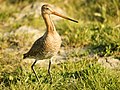 The globally near threatened (NT) black-tailed godwit is found in Thy National Park.
 -
![The large Hercules ant (Camponotus herculeanus) has established in some of the plantations here. It is either rare or absent from the rest of Denmark.[2]](//upload.wikimedia.org/wikipedia/commons/thumb/f/f9/Formica_high_res.jpg/80px-Formica_high_res.jpg) The large Hercules ant (Camponotus herculeanus) has established in some of the plantations here. It is either rare or absent from the rest of Denmark.[2]
The large Hercules ant (Camponotus herculeanus) has established in some of the plantations here. It is either rare or absent from the rest of Denmark.[2] -
 Black crowberries. Many of the plants in the national park are edible.
 -
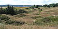 View across the dune heaths of Hanstholm game preserve.
 -
 The slender water lobelias are indicator species of the very clean lakes and ponds in the national park.
 -
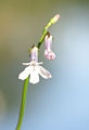
 The peculiar pillwort fern is near threatened (NT) on a global scale, but found growing in Thy.
.jpg)
![The large Hercules ant (Camponotus herculeanus) has established in some of the plantations here. It is either rare or absent from the rest of Denmark.[2]](/wiki/%E0%B4%AA%E0%B5%8D%E0%B4%B0%E0%B4%AE%E0%B4%BE%E0%B4%A3%E0%B4%82:Formica_high_res.jpg)


അവലംബം[തിരുത്തുക]
- ↑ Welcome to the National Park of Thy Archived 2016-03-03 at the Wayback Machine., Danish Forest and Nature Agency
- ↑ The Nature in National Park Thy Archived 2013-12-17 at the Wayback Machine. The Biological Association of Northwest Jutland. p.4